Resilient Landscapes
Resilient Landscapes Program
Working with Nature to Foster Resilience
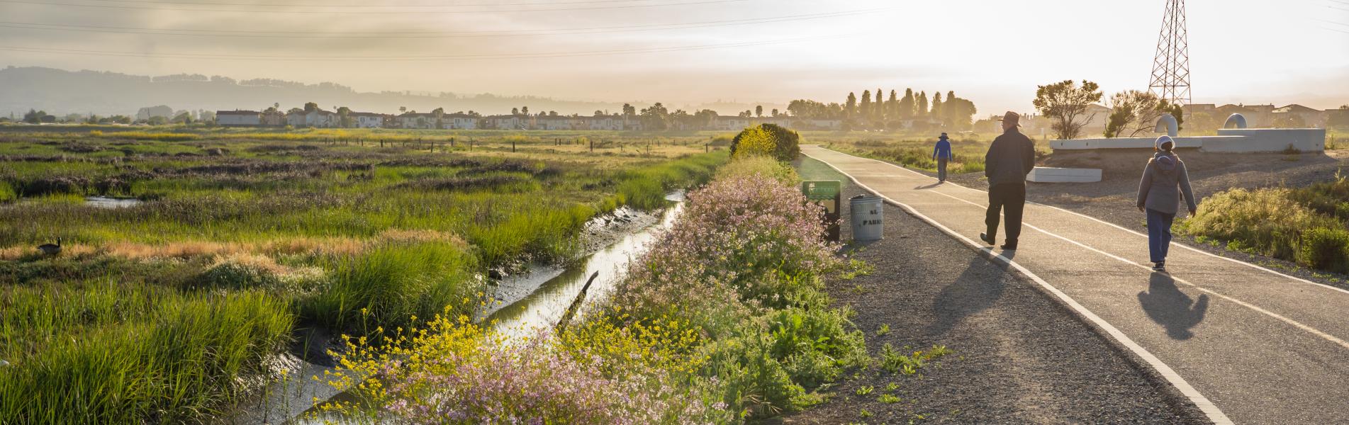
The Resilient Landscapes team develops innovative, long-range, nature-based strategies to improve the health of our shorelines, cities, and rural areas.
Vision: We envision a future where healthy, resilient landscapes support thriving human and ecological communities.
Mission: Informed by a deep understanding of past, present, and future conditions, we provide science-based actionable guidance for holistic nature-based solutions to stressors from climate change, landscape modification, habitat loss, and inequity.
Read more about the program


Historical ecology has formed the foundation of SFEI’s Resilient Landscapes Program since its inception. This interdisciplinary field synthesizes diverse historical records to learn how habitats were distributed and ecological functions were maintained within the native California landscape.

Given the dramatic changes to California landscapes during the past two centuries, we often have only rudimentary understanding of the systems we seek to protect and enhance. In fact, there is a growing recognition that restoration efforts have often misinterpreted earlier conditions, resulting in missed opportunities and, in some cases, failed projects. However, the development of accurate, reliable, and broadly-supported pictures of historical condition and change can help correctly identify the causes of current challenges, and reveal previously unrecognized management options. Understanding how streams, wetlands, and woodlands were organized along physical gradients helps scientists and managers develop new strategies for more integrated and functional landscape management. Historical reconstructions also educate and engage the public imagination, increasing public will for local and regional landscape stewardship.
SFEI's historical ecology studies have contributed to numerous restoration projects in the Bay Area and coastal California. Projects are carried out in collaboration with local partners and with a team of regional and local science advisers, with results made broadly available through website, publication, and presentation. SFEI's innovative approaches have been featured in New Scientist Magazine, Landscape Journal, The Living Landscape: An Ecological Approach to Landscape Planning, the McGraw-Hill Encyclopedia of Science and Technology, and the Historical Ecology Handbook, as well as general audience science programs such as KQED’s QUEST and the Saving the Bay documentary.
For more information, please contact [email protected].
|
|
Sacramento Valley Historical Ecology | The Sacramento Valley Historical Ecology Study will synthesize historical data in order to understand the ecological, hydrological, and geomorphic conditions of the valley... |
|
|
Lower Salinas River Historical Ecology Reconnaissance | This report summarizes the results of an initial study of historical conditions (i.e., prior to significant Euro- American modification) on the lower Salinas River (... |
|
|
Sunset Natural Resilience Project | The Sunset Natural Resilience Project (SNRP) consists of six individual but related projects to increase the ability of human and natural communities to adapt to and prepare... |
|
|
Laguna de Santa Rosa Master Restoration Plan | The Laguna de Santa Rosa is an expansive freshwater wetland complex that hosts a rich diversity of plant and wildlife species, and is also home to a thriving agricultural... |
|
|
Reconnecting Riverside with its River: Integrating Historical and Urban Ecology for a Healthier Future | This study focuses on a segment of the Santa Ana River Parkway in and around the City of Riverside, where multiple habitat restoration projects are underway. |
|
|
Hidden Nature SF | Hidden Nature SF brings a new perspective to our view of San Francisco, studying the city’s historical ecology in order to engage the public in re-imagining San Francisco’s... |
|
|
Laguna de Santa Rosa Historical Ecology Initiative | The Laguna de Santa Rosa (Laguna) watershed spans 256 square miles and supports a unique complex of biologically diverse ecosystems. |
|
|
Next Generation Urban Greening | SFEI is working with partners across the Bay Area to design tools to help cities achieve biodiversity, stormwater, and climate benefits through multifunctional green... |
|
|
Landscape Scenario Planning Tool | This project is a tool for planning scenarios of landscape-scale restoration. The tool is designed to inform ongoing and future restoration planning efforts. |
|
|
Healthy Watersheds Resilient Baylands | Through the EPA-funded Healthy Watersheds Resilient Baylands project, SFEI and sixteen partner organizations are developing multi-benefit tools to enhance climate change... |
|
|
Tijuana River Valley Historical Ecology Investigation | The Tijuana River Valley Historical Ecology Investigation synthesized hundreds of historical maps, photographs, and texts to reconstruct the the ecological, hydrological, and... |
|
|
Historical Wetlands of the Southern California Coast: An Atlas of US Coast Survey T-Sheets 1851-1889 | This project is the first regional assessment of the relative distribution and abundance of different wetland habitat types along the historical Southern California coastline... |
|
|
Ventura County Historical Ecology Study | This project investigated the historical ecological patterns and hydrological dynamics of most of lowland Ventura County. |
|
|
East Contra Costa County Historical Ecology Study | SFEI conducted a historical ecology assessment of natural resources in East Contra Costa County in partnership with Contra Costa County and the |
|
|
Alameda Creek Historical Ecology Study | The Alameda Creek Historical Ecology Study assesses watershed conditions prior to significant Euro-American modification, as a basis for understanding subsequent changes in... |
|
|
Delta Landscapes Scenario Planning Tool | This project is a tool for planning scenarios of landscape-scale restoration of the Delta. The tool is designed to inform ongoing and future restoration planning efforts in... |
|
|
Peninsula Watershed Historical Ecology Study | Nestled in the rugged coastal mountains between San Francisco and Silicon Valley lies one of the ecological treasures of the San Francisco Bay Area: the Peninsula Watershed. |
|
|
Russian River Watershed Projects at the San Francisco Estuary Institute | Our projects in the Russian River Watershed help us to understand our past, understand our present, and envision our future. Learn more about what SFEI is doing in... |
|
|
Exploring Landscape Change: the Wildcat Creek Watershed | This study provided information for the Wildcat Creek portion of the Oakland Museum's "Creek and Watershed Map of Richmond and Vicinity" Related project: |
|
|
Baylands Ecosystem Habitat Goals Project | SFEI's Letitia Grenier served as lead scientist of the Baylands Ecosystem Habitat Goals Project, which yielded a report called The Baylands and Climate Change: What We... |
|
|
Resilient Silicon Valley | Tools for the creation of a resilient Silicon Valley ecosystem. |
|
|
U.S. Coast Survey Maps of SF Bay | Under the direction of some of the leading American scientists of the 19th century, the United States Coast Survey (USCS) created exceptionally accurate and detailed maps of... |
|
|
Upper Penitencia Creek: Historical Ecology Assessment | Upper Penitencia Creek, on the eastern side of Santa Clara Valley, has locally significant potential for stream restoration and anadromous fish recovery. |
|
|
Seeing What the Land Remembers: Geography, Ecology, and the History of Place | An interdisciplinary discussion panel at UC Berkeley's Townsend Center for the Humanities. |
|
|
Surveying the Bay through Time with George E. Russell: Aero Foto | An art/science exhibit using photographic prints and graphic stories to present previously-unseen work by one of the first aerial photographers of the region. |
|
|
Sonoma Creek Historical Ecology Intro | Historical ecological and geomorphic change in the Sonoma Creek watershed Partners Sonoma Ecology Center |
|
|
South Santa Clara Valley Historical Ecology Study | This study assesses historical conditions and landscape change in the southern part of the Santa Clara Valley. It is designed to inform strategies for natural flood... |
|
|
Rodeo Lagoon (Marin County) | This report is submitted in the context of transportation planning and improvement of public access to |
|
|
Historical Wetlands of the Southern California Coast Phase 2: Historical Extent and Change Over Time | This project builds on earlier efforts to provide comprehensive analysis of the 40 T-sheets that cover the southern California Bight (S |
|
|
Ecological Connections between Baylands and Uplands | Marin County is updating its Countywide Plan, which has the objective of meeting the needs of the present without compromising the future. |
|
|
Historical Ecology of Lower San Francisquito Creek | The primary goal of this project was to produce GIS layers and georeferenced imagery for use by the planning and engineering team of the |
|
|
Historical Ecology of Miller Creek | This project provides an introduction to the historical land use and landscape changes in the Miller Creek watershed in Marin County. |
|
|
U.S. Coast Survey Maps of California (South Coast) | Until the advent of this new map viewer, a valuable resource was largely unavailable to coastal planners. Now, US Coastal Survey maps are free for broad use. |
|
|
Historical Tidal-Terrestrial Transition Zone in South SF Bay | The tidal-terrestrial transition zone (T-zone) occupies the gradient between the intertidal zone and terrestrial (i.e., levee faces, valleys, hillsides, alluvial fans, and... |
|
|
T-Sheet User Guide | This guide discusses the historical maps of San Francisco Bay produced by the United States Coast Survey (USCS) and their application to present-day environmental efforts in... |
|
|
Baylands and Creeks of South San Francisco Bay | A map of historical habitats and channels in the South Bay. |
|
|
Mapping Shoreline Change in San Pablo Bay | Using a systematic, empirical, and repeatable approach, we mapped the location of the shorelines in San Pablo Bay at three points in time: 1855, 1993, and 2010. We then... |
|
|
Resilient By Design: Science Advisors | The challenges of accelerating sea level rise and aging shoreline infrastructure are creating a once-in-a-century opportunity to redesign the Bay shore. |
|
|
Landscape Vision for Calabazas Creek, San Tomas Aquino Creek and Pond A8 | SFEI released a resilient landscape vision for the interface of Calabazas Creek, San Tomas Aquino Creek, and Pond A8 in South San Francisco Bay that benefits both flood... |
|
|
San Gabriel River Historical Ecology Project | The goal of this project was to use a variety of historical resources to answer the following questions |
|
|
Wildcat Creek Landscape History | People have lived along Wildcat Creek since 3,000 to 4,000 BP. By that time, Sea level rise had slowed, and the Bay's size had stabilized, allowing broad mudflats and tidal... |
|
|
Coyote Creek Watershed Historical Ecology Study | This report synthesizes historical evidence into a picture of how Coyote Creek looked and functioned before intensive modification. Prepared for the Santa Clara Valley Water... |
|
|
Upper Penitencia Creek: Resilient Landscape Vision | The San Francisco Estuary Institute-Aquatic Science Center and the Santa Clara Valley Water District worked with technical advisors and a group of local stakeholders to... |
|
|
Understanding Change in Primary Production at a Landscape Scale in the Delta | Constraints on primary production and the relative importance of different production sources to the food web remain major uncertainties in the Delta ecosystem. Newly... |
|
|
The Collaborative Research Program at Quiroste Valley | This collaborative team of Indian scholars, archaeologists, ecologists, and land managers is embarking on an innovative research program with two primary goals. |
|
|
Sacramento-San Joaquin Delta Historical Ecology Study | The San Francisco Estuary Institute-Aquatic Science Center, in collaboration with the California Department of Fish and Game, has completed a historical ecology study of the... |
|
|
Petaluma Valley Historical Hydrology and Ecology Study | This project reconstructs the historical hydrology and ecology of the Petaluma River watershed prior to major Euro-American modification. |
|
|
North San Diego County Lagoons Historical Ecology Study | The Northern San Diego County Lagoons Historical Ecology Investigation draws on hundreds of historical documents to analyze and reconstruct historical landscape conditions... |
|
|
Napa Valley Historical Ecology Study | Friends of the Napa River, the Napa County Resource Conservation District, and SFEI have carried out investigations into the historical Napa Valley landscape. |
|
|
Napa Valley Historical Ecology Atlas | The Napa Valley Historical Ecology Atlas takes readers on a richly illustrated tour of the iconic Napa Valley landscape from 200 years ago to the present and future. Using... |
|
|
Mission Bay Historical Ecology Reconnaissance Study | The Mission Bay Historical Ecology Reconnaissance Study, completed in February of 2016, collected and organized data on the historical conditions of Mission Bay in San Diego... |
|
|
Miller Creek Stewardship | Miller Creek was recently recognized by EPA biologist Rob Leidy as a high priority watershed for |
|
|
Lower Walnut Creek Historical Ecology Study | During the mid-19th century, the lower Walnut Creek watershed was a landscape dominated by extensive wetlands, meandering creeks, and grassy plains. |
|
|
Lower Laguna de Santa Rosa and Mark West Creek: Changes in Historical Channel Alignment | Over the past century and a half, the hydrology of the Laguna de Santa Rosa watershed has been altered by a variety land use changes, including urbanization, agricultural... |
|
|
John Muir/Mt. Wanda Historical Ecology Reconnaissance Study | The Mt. Wanda Historical Ecology Investigation assembled historical landscape data for the Mt. |
|
|
Historical Ecology and Landscape Change in the Central Laguna de Santa Rosa | This study synthesizes a diverse array of data to examine the ecological patterns, ecosystem functions, and hydrology that characterized a central portion of the Laguna de... |
|
|
EBDA Sea Level Rise Adaptation Planning Project | Historically, freshwater was an important component of the baylands ecosystem, creating salinity gradients that added physical and ecological diversity to the baylands... |
|
|
Dutch Slough Community Park and Public Access | This project provides a review of existing data and studies to verify conditions for the Dutch Slough Wetland Restoration Project. |
|
|
Delta: McCormack-Williamson Tract | The McCormack-Williamson Tract (MWT) was purchased in 1999 by The Nature Conservancy with CALFED Ecosystem Restoration Program (ERP) funds. Though today it looks like many... |
|
|
Delta Landscapes Project | The Delta Landscapes Project, which began in 2012 and will run through 2016, has developed a body of work to inform landscape-scale restoration of the Sacramento-San Joaquin... |
|
|
Collaborative Cultural Landscape Research: Ethnoecological Fire Traditions on the Central Coast | Since 2006, together with colleagues at UC Berkeley, CA State Parks, UC Santa Cruz, BLM, the National Park Service, the Muwekma Ohlone and Amah Mutsun Tribes, and numerous... |
|
|
BayBoards | Despite its solid and impressive appearance, the urban Bay Area landscape remains a thin, freshly-constructed veneer over the native landscape. |
|
|
Ballona Creek Historical Ecology Project | The Ballona Creek project supports historical research conducted by the Southern California Coastal Water Research Project and CSU-Northridge on the historical ecology of the... |
|
|
Western Santa Clara Valley Historical Ecology Study | This study produced GIS layers and a report describing historical habitats in the Guadalupe, West Valley, and Lower Peninsula Watershed Management Areas of Santa Clara County... |
|
|
Flood Control 2.0 | Flood Control 2.0 is an ambitious regional effort aimed at helping restore stream and wetland habitats, water quality, and shoreline resilience around San Francisco Bay. The... |
|
|
Santa Clara Valley historical ecology GIS | This dataset represents a reconstruction of the historical landscape patterns, including channel and habitat distribution, of the Santa Clara Valley and adjacent baylands |


Year of Publication: 2023
Year of Publication: 2020
Year of Publication: 2018
Year of Publication: 2017
Year of Publication: 2016
Year of Publication: 2015
Year of Publication: 2014
Year of Publication: 2013
Year of Publication: 2012
Year of Publication: 2011
Year of Publication: 2010
Year of Publication: 2009
Year of Publication: 2008
Year of Publication: 2007
Year of Publication: 2006
Year of Publication: 2005
Year of Publication: 2004
Year of Publication: 2003
Year of Publication: 2002
Year of Publication: 2001
Year of Publication: 2000
Year of Publication: 1999
Year of Publication: 1998
Year of Publication: 1997
Year of Publication: 1995
As sea levels continue to rise at an increasing rate, communities will need to adapt the California shoreline to create greater social, economic, and ecological resilience. Sea-level rise, together with high tides and storm surges, will impact roads, wastewater infrastructure, low-lying communities, and ecosystems in many of our region’s most vulnerable areas. Shoreline ecosystems provide multiple benefits such as habitat for wildlife, protection from storm surges, carbon sequestration, and recreation opportunities. With our Shoreline Resilience Focus Area, we continuously work toward the goal of maintaining and improving our natural and built shorelines while making them more resilient to climate change.
With a unique skill set of skills and relationships drawn from decades of working in the San Francisco Bay community, we bring together diverse stakeholders to arrive at science-based landscape-scale solutions for shoreline restoration, adaptation, and resilience. We bring expertise in geomorphology, wetlands ecology, sediment science, planning, and landscape design to make relevant scientific information available for decision-making. We develop regional-scale scientific studies, geospatial tools, and site-scale visions for shorelines across California, focusing on San Francisco Bay and Southern California wetlands. We partner with regional resource agencies, flood control districts, local governments, NGOs, community organizations, wastewater treatment plants, land trusts, and others to develop natural and nature-based strategies for shoreline adaptation with multiple co-benefits. We also serve as advisors to agencies on specific projects, governance decisions, and policy changes.
For more information, please contact [email protected].
|
|
Preparing for the Storm | Catalyzed by the extensive damages caused by the Winter 2016-2017 storms and the opportunity to align flood response with major habitat improvement, Preparing for the Storm ... |
|
|
State of the Estuary Report | The State of the Estuary Report evaluates the status and trends of a suite of indicators selected to represent ecosystem health in the San Francisco Bay and Sacramento-San... |
|
|
New Life for Eroding Shorelines | The New Life for Eroding Shorelines project explores living shoreline approaches for sea level rise adaptation that can reduce erosion at the marsh edge and improve... |
|
|
Baylands Resilience Framework | SFEI helps planners, regulatory agencies, community-based organizations, and other stakeholders make informed decisions about where and how to implement nature-based... |
|
|
Regional Analysis of Potential Beneficial Use Locations: San Francisco Bay | SFEI and partners are engaged in a long-term effort to define and quantify baylands resilience for San Francisco Bay through the Baylands |
|
|
Where creeks meet baylands: opportunities to re-establish freshwater and sediment delivery to the baylands of San Francisco Bay | As baylands restoration and climate change alter the ecosystems of the Bay, novel restoration approaches are needed to meet growing challenges. |
|
|
Conceptual Understanding of Fine Sediment Transport in San Francisco Bay | Sediment is a lifeblood of San Francisco Bay. |
|
|
Nature Based Solutions for Nutrient Removal | High nutrient concentrations can cause increased phytoplankton biomass, low dissolved oxygen, and increased harmful algal blooms and toxins, with detrimental effects on... |
|
|
Petaluma River Baylands Strategy | Historically, the Petaluma River Baylands were home to a large, complex, and biologically diverse landscape of tidal habitats, including marshes, mudflats, and open water. ... |
|
|
Shallow Groundwater Response to Sea Level Rise | The response of shallow groundwater to sea-level rise is a relatively new field of study. |
|
|
Sediment for Survival | This project analyzes current data and climate projections to determine how much sediment may be available for tidal marshes and mudflats and how much sediment may be needed... |
|
|
Healthy Watersheds Resilient Baylands | Through the EPA-funded Healthy Watersheds Resilient Baylands project, SFEI and sixteen partner organizations are developing multi-benefit tools to enhance climate change... |
|
|
Historical Wetlands of the Southern California Coast: An Atlas of US Coast Survey T-Sheets 1851-1889 | This project is the first regional assessment of the relative distribution and abundance of different wetland habitat types along the historical Southern California coastline... |
|
|
Sunnyvale Shoreline Resilience Vision | The Sunnyvale Shoreline Resilience Vision is an ongoing collaborative effort between a group of organizations deeply invested in long term regional resilience and interested... |
|
|
Baylands Ecosystem Habitat Goals Project | SFEI's Letitia Grenier served as lead scientist of the Baylands Ecosystem Habitat Goals Project, which yielded a report called The Baylands and Climate Change: What We... |
|
|
U.S. Coast Survey Maps of SF Bay | Under the direction of some of the leading American scientists of the 19th century, the United States Coast Survey (USCS) created exceptionally accurate and detailed maps of... |
|
|
Rodeo Lagoon (Marin County) | This report is submitted in the context of transportation planning and improvement of public access to |
|
|
LTMS Science Framework Update | The San Francisco Bay Long-Term Management Strategy (LTMS) is a collaborative partnership with the purpose to conduct dredging activities in an economically prudent and... |
|
|
Historical Wetlands of the Southern California Coast Phase 2: Historical Extent and Change Over Time | This project builds on earlier efforts to provide comprehensive analysis of the 40 T-sheets that cover the southern California Bight (S |
|
|
Ecological Connections between Baylands and Uplands | Marin County is updating its Countywide Plan, which has the objective of meeting the needs of the present without compromising the future. |
|
|
Historical Ecology of Lower San Francisquito Creek | The primary goal of this project was to produce GIS layers and georeferenced imagery for use by the planning and engineering team of the |
|
|
Historical Ecology of Miller Creek | This project provides an introduction to the historical land use and landscape changes in the Miller Creek watershed in Marin County. |
|
|
South Baylands Mercury Project (SBMP) | We have developed biosentinel species indicators for wetlands to help the SBMP management team make decisions relative to mercury risk about where and how to restore salt... |
|
|
South Bay Salt Pond Restoration Science Team | The SBSPRP Science Team provides review to project consultants and assists the Project Management Team with the development of a long-range science program for the project. |
|
|
South Bay Salt Pond Landscape Synthesis Report | This synthesis focuses on the form and function of South Bay landscapes to address the following two issues maintaining and improving functioning of the South Bay... |
|
|
State of the Bay | The State of the Bay report provides independent, science-based reporting on the state of the health of the San Francisco Estuary ecosystem. |
|
|
U.S. Coast Survey Maps of California (South Coast) | Until the advent of this new map viewer, a valuable resource was largely unavailable to coastal planners. Now, US Coastal Survey maps are free for broad use. |
|
|
Historical Tidal-Terrestrial Transition Zone in South SF Bay | The tidal-terrestrial transition zone (T-zone) occupies the gradient between the intertidal zone and terrestrial (i.e., levee faces, valleys, hillsides, alluvial fans, and... |
|
|
Assessment of Removal of Creosote-Treated Pilings and Structures from San Francisco Bay | The remnants of old creosote-treated piers and dilapidated maritime facilities are common sights along intertidal and subtidal shorelines. Removal of these structures has ... |
|
|
Head of Tide | SFEI completed a pilot study focused on creating a framework for a rapid protocol that can be used to delineate the current and future head of tide zone for San Francisco Bay... |
|
|
T-Sheet User Guide | This guide discusses the historical maps of San Francisco Bay produced by the United States Coast Survey (USCS) and their application to present-day environmental efforts in... |
|
|
Estuary 2100 Technical Support - Round 1 | Estuary 2100 is an integrated set of ecosystem-based projects aimed at protecting and enhancing San Francisco Estuary, while anticipating the effects of our changing climate. |
|
|
Baylands and Creeks of South San Francisco Bay | A map of historical habitats and channels in the South Bay. |
|
|
Special Study on Bulk Density | Sediment bulk density is the total mass of mineral and organic sediment within a defined volume. |
|
|
Mapping Shoreline Change in San Pablo Bay | Using a systematic, empirical, and repeatable approach, we mapped the location of the shorelines in San Pablo Bay at three points in time: 1855, 1993, and 2010. We then... |
|
|
San Francisco Bay Shore Inventory | SFEI is developing an online interactive map to support regional planning and assessment given accelerated sea level rise around the Bay. |
|
|
Resilient By Design: Science Advisors | The challenges of accelerating sea level rise and aging shoreline infrastructure are creating a once-in-a-century opportunity to redesign the Bay shore. |
|
|
San Francisco Bay Shoreline Adaptation Atlas: Working with Nature to Plan for Sea Level Rise | In partnership with SPUR, The Operational Landscape Units project, funded by the |
|
|
Resilience Atlas | The Resilience Atlas is a compilation of cutting-edge science, creative visions and relevant spatial data to support planners, designers, polic |
|
|
North Bay Mercury Biosentinel Monitoring | In 2011-2014 SFEI and UC Davis developed and implemented a multi-species biosentinel monitoring approach as an effective and efficient way of monitoring methylmercury... |
|
|
Landscape Vision for Calabazas Creek, San Tomas Aquino Creek and Pond A8 | SFEI released a resilient landscape vision for the interface of Calabazas Creek, San Tomas Aquino Creek, and Pond A8 in South San Francisco Bay that benefits both flood... |
|
|
Sonoma Creek Baylands Strategy | The Sonoma Creek Baylands Strategy is a comprehensive high-level plan for landscape-scale restoration, flood protection, and public access in the tidal Lower Sonoma Creek... |
|
|
Petaluma Valley Historical Hydrology and Ecology Study | This project reconstructs the historical hydrology and ecology of the Petaluma River watershed prior to major Euro-American modification. |
|
|
North San Diego County Lagoons Historical Ecology Study | The Northern San Diego County Lagoons Historical Ecology Investigation draws on hundreds of historical documents to analyze and reconstruct historical landscape conditions... |
|
|
Mission Bay Historical Ecology Reconnaissance Study | The Mission Bay Historical Ecology Reconnaissance Study, completed in February of 2016, collected and organized data on the historical conditions of Mission Bay in San Diego... |
|
|
Lower Walnut Creek Historical Ecology Study | During the mid-19th century, the lower Walnut Creek watershed was a landscape dominated by extensive wetlands, meandering creeks, and grassy plains. |
|
|
EBDA Sea Level Rise Adaptation Planning Project | Historically, freshwater was an important component of the baylands ecosystem, creating salinity gradients that added physical and ecological diversity to the baylands... |


Year of Publication: 2023
Year of Publication: 2022
Year of Publication: 2021
Year of Publication: 2020
Year of Publication: 2019
Year of Publication: 2018
Year of Publication: 2017
Year of Publication: 2016
Year of Publication: 2015
Year of Publication: 2014
Year of Publication: 2011
The Sacramento-San Joaquin Delta supplies freshwater to a large portion of California’s cities and agriculture, supports an agricultural economy and culture, and is home to native wildlife found nowhere else in the world. This complex region is hampered by many environmental challenges, including an over-allocated water supply, invasive species, water quality problems, novel ecosystems that no longer support desired functions, aging infrastructure, and a complex management structure. Beyond these challenges, sea level rise, other impacts from climate change, and earthquakes pose significant risks to Delta ecosystems, agriculture and water supply. The Delta Science and Management Focus Area investigates the ecology, hydrology and geomorphology of the Delta to inform decision making in this complex environment.
The three-part Delta Landscapes Project investigated the historical ecosystems of the Delta, examined how these ecosystems have been modified in the current landscape, and provided a holistic, aspirational approach to restoration. Building on this foundation, SFEI has contributed to multiple regional planning efforts and investigations of how the Delta supports specific functions, including primary production, salmon rearing habitat, and carbon storage. Our work from many of these projects is incorporated in the Delta Landscapes Scenario Planning Tool, a set of resources to assist users with developing, analyzing, and evaluating different land use scenarios to inform ongoing and future restoration planning efforts.
For more information, please contact [email protected].
|
|
State of the Estuary Report | The State of the Estuary Report evaluates the status and trends of a suite of indicators selected to represent ecosystem health in the San Francisco Bay and Sacramento-San... |
|
|
Delta Wetlands and Resilience: Blue Carbon and Marsh Accretion | Restoring wetlands in the Sacramento-San Joaquin Delta (Delta) can mitigate subsidence, sequester carbon, reduce GHG emissions, and provide habitat for wetland dependent... |
|
|
Suisun Landscapes | The largest brackish marsh on the West Coast, Suisun Marsh is a unique transitional landscape between San Francisco Bay and the Sacramento-San Joaquin Delta. |
|
|
Blue Carbon Science to Support Climate Action | Working with other scientists, agency staff, and regional and state-level managers and planners, we are building alignment and capacity for blue carbon quantification through... |
|
|
Landscape Scenario Planning Tool | This project is a tool for planning scenarios of landscape-scale restoration. The tool is designed to inform ongoing and future restoration planning efforts. |
|
|
Salmon Habitat Quantification Development | The Chinook salmon habitat quantification tool is a science-based approach for use by restoration planners to evaluate existing or potential habitat across spatially- and... |
|
|
Understanding Change in Primary Production at a Landscape Scale in the Delta | Constraints on primary production and the relative importance of different production sources to the food web remain major uncertainties in the Delta ecosystem. Newly... |
|
|
Sacramento-San Joaquin Delta Historical Ecology Study | The San Francisco Estuary Institute-Aquatic Science Center, in collaboration with the California Department of Fish and Game, has completed a historical ecology study of the... |
|
|
Dutch Slough Community Park and Public Access | This project provides a review of existing data and studies to verify conditions for the Dutch Slough Wetland Restoration Project. |
|
|
Delta Salmon Rearing | The objective of this project is to summarize existing research and knowledge around suitable rearing habitat for Chinook salmon in the Sacramento-San Joaquin Delta; identify... |
|
|
Delta: McCormack-Williamson Tract | The McCormack-Williamson Tract (MWT) was purchased in 1999 by The Nature Conservancy with CALFED Ecosystem Restoration Program (ERP) funds. Though today it looks like many... |
|
|
Delta Landscapes Project | The Delta Landscapes Project, which began in 2012 and will run through 2016, has developed a body of work to inform landscape-scale restoration of the Sacramento-San Joaquin... |


Year of Publication: 2024
Year of Publication: 2022
Year of Publication: 2020
Year of Publication: 2019
Year of Publication: 2017
Year of Publication: 2016
Year of Publication: 2014
Year of Publication: 2013
Year of Publication: 2012
 The Wetland Monitoring & Assessment Focus Area provides scientific and technological support for coordinated, collaborative, cost-effective wetland planning, management, assessment, and reporting across government policies and programs. Working with other Focus Areas at SFEI, and with many outside partners, we help all interests develop place-based goals for wetland protection by developing and implementing tools, such as Historical Ecology, the California Aquatic Resource Inventory (CARI), and the California Rapid Assessment Method for wetlands (CRAM) to understand how the abundance, diversity, and condition of wetlands have changed due to nature and people, and to explore alternative ways to protect and restore wetlands for the future.
Products of the WMA Focus Area are designed for consistent adoption into wetland regulatory and management procedures at all levels of government, to promote coordinated, consensus-based, scientifically sound wetland and stream restoration and protection. Products include WRAMP, the state wetland definition and delineation method, California Aquatic Resource Inventory (CARI) and its eco-regional versions, Habitat Project Tracker, the Riparian Zone Estimator Tool (RipZET), the California Rapid Assessment Method for wetlands and streams (CRAM), Landscape Profile Tool, Green Plan-IT for large scale restoration planning, and the Science Frameworks for the Russian River Regional Monitoring Program (R3MP) and the Bay-Delta Wetlands Regional Monitoring Program (Wetlands RMP).
The WMA POD features projects that integrate all of these products into quantitative watershed-based assessments of wetland and riparian abundance, diversity, distribution and condition that are accessible through EcoAtlas to support a watershed approach to aquatic resource restoration and protection. Example assessments have been produced for the Upper Truckee River (Alpine Co), Santa Clara County watersheds, Wildcat Creek (Alameda Co), Napa River (Napa Co), and Mark West Creek (Sonoma Co). WMA personnel serve on many regional, state, and national committees to advise wetland policies, programs, and projects.
For more information, please contact [email protected]
|
|
California Aquatic Resource Inventory (CARI) | The California Aquatic Resources Inventory (CARI) is a Geographic Information System (GIS) based map of wetlands, streams, and riparian areas within California that is hosted... |
|
|
EcoAtlas Toolset Training and Outreach Plan | The California Wetland Monitoring Workgroup’s (CWMW) State Wetland and Riparian Area Monitoring Plan (WRAMP) |
|
|
RipZET: A GIS-based Tool for Estimating Riparian Zones | The Riparian Zone Estimator Tool (RipZET) is a decision support tool developed by the San Francisco Estuary Institute and Aquatic Science Center for the California Riparian... |
|
|
Santa Clara Valley Water District Priority D5 Project's Watershed Condition Assessments (2010 to present) | https://www.valleywater.org/project-updates/2012-d5-ecological-data-collection-and-analysisSFEI and the Santa Clara Valley Water District's (Valley Water) Priority D-5... |
|
|
Tahoe WRAMP Demonstration: Watershed Assessment | The Tahoe WRAMP Watershed Demonstration Project transferred statewide wetland monitoring and assessment tools to Sierra Nevada environmental agencies and organizations by... |
|
|
Coastal Wetlands, Beaches and Watersheds Inventory | The Ocean Protection Council (OPC) and SFEI will develop an inventory of the wetlands and other surface waters of all California’s coastal HUC-8 watersh |
|
|
Bay Area Aquatic Resource Inventory (BAARI) | The Bay Area Aquatic Resources Inventory (BAARI) is a GIS base map of the Bay Area's wetlands, open water, streams, ditches, tidal marshes and flats, and riparian areas.... |
|
|
Russian River Regional Monitoring Program: Comprehensive Basemap of Surface Waters and Riparian Areas | This project will build on existing projects funded by the CA State Water Board, Ocean Protection Council, Sonoma Ecology Center, and Sonoma County to produce a basemap of... |
|
|
Vernal Pool Habitat Restoration and Protection CRAM Tools for the Central Valley, CA | The California Wetland Program Plan (WPP) seeks to strengthen protection for wetlands in many ways, |
|
|
Alameda Creek Historical Ecology Study | The Alameda Creek Historical Ecology Study assesses watershed conditions prior to significant Euro-American modification, as a basis for understanding subsequent changes in... |
|
|
Eelgrass Data Management and Project Tracking | Eelgrass (Zostera marina and Z. pacifica) is recognized as an important ecological resource in nearshore open coast areas, shallow bays, and estuaries... |
|
|
Six County Aquatic Resource Inventory | The US Army Corps of Engineers, Sacramento Division updated wetland and stream maps for the 6 county area (Sacramento, Placer, Yolo, El Dorado, Yuba, and Sutter Counties) to... |
|
|
EcoAtlas | EcoAtlas is a set of tools for generating, assembling, storing, visualizing, sharing, and reporting environmental data and information. |
|
|
Russian River Watershed Projects at the San Francisco Estuary Institute | Our projects in the Russian River Watershed help us to understand our past, understand our present, and envision our future. Learn more about what SFEI is doing in... |
|
|
Contaminant Data Download and Display (CD3) | Contaminant Data Display and Download Tool or CD3 is an innovative visualization tool for accessing water quality data for the San Francisco Bay-Delta and northern montane |
|
|
Wetlands Regional Monitoring Project | This Prop 50 - funded project was a three-year effort to monitor and track changes in Bay Area wetland condition. This wetland monitoring toolkit meets basic information... |
|
|
Baylands Ecosystem Habitat Goals Project | SFEI's Letitia Grenier served as lead scientist of the Baylands Ecosystem Habitat Goals Project, which yielded a report called The Baylands and Climate Change: What We... |
|
|
Coyote Creek Native Ecosystem Enhancement Tool | The Coyote Creek Native Ecosystem Enhancement Tool (CCNEET, neet. ecoatlas.org) is an online decision-support tool to identify opportunities to improve ecological conditions... |
|
|
Visualizing and Sharing Intensive Data Assessments | With California's drought rapidly changing the outlook for natural resources, decision-makers must be equipped with information and tools that facilitate clear and rapid... |
|
|
North Bay Mercury Biosentinel Monitoring | In 2011-2014 SFEI and UC Davis developed and implemented a multi-species biosentinel monitoring approach as an effective and efficient way of monitoring methylmercury... |
|
|
Montezuma Technical Review Team | The Montezuma wetland restoration project is returning ~2,000 acres of diked baylands to tidal, seasonal, and managed wetlands in an eastern portion of Suisun Bay near the... |
|
|
Statewide Wetland Tracking, Science, and Policy Development Support | SFEI’s Wetland Science Focus Area’s Director, Josh Collins, is a leader in the coordination of statewide science advisory teams and acquiring funding to develop monitoring... |
|
|
Stream Goals Demonstration Project | The SFEI Waterlands Group (Wetland Science, Watershed Science, and Historical Ecology) is developing a workshop for watershed planners to investigate the technical and policy... |
|
|
Santa Rosa Plain Wetlands Profile: A Demonstration of WRAMP | The Santa Rosa Plain WRAMP project demonstrated the use of the State’s standardized monitoring and assessment tools in a North Coast watershed setting and described how the... |
|
|
Ballona Creek Historical Ecology Project | The Ballona Creek project supports historical research conducted by the Southern California Coastal Water Research Project and CSU-Northridge on the historical ecology of the... |
|
|
California Rapid Assessment Method (CRAM) | CRAM is a standardized, scientifically defensible rapid assessment method for monitoring the ecological conditions of wetlands throughout California. Because it is... |
|
|
Developing a Sustainable Business Model for the EcoAtlas Toolset | This project is funded by a USEPA wetland development grant (2015-2017) to develop a recommended funding and business model for the EcoAtlas toolset. EcoAtlas is a ... |
|
|
Lahontan EcoAtlas Development | This project will create an EcoAtlas user community for the Lahontan region of the Sierra Nevada to develop capacities within the region to apply EcoAtlas through existing... |
|
|
Habitat Restoration Project Tracking | This project expands the current capabilities of the wetland project tracking system for the monitoring and assessment of California’s aquatic resources to meet the project... |
|
|
Evaluation of CRAM performance for assessing wetland stress, small wetlands, and wetland habitat development | Caltrans funded this wetlands research to fill important gaps in knowledge about the ability of the California Rapid Assessment Method (CRAM) to assess small wetlands,... |
|
|
National Hydrography Dataset (NHD) Data Stewardship | As the San Francisco Bay Area Regional Steward for the USGS National Hydrography Dataset, SFEI has been working with National and State USGS NHD representatives to coordinate... |
|
|
California Wetlands Portal | The California Wetlands Portal, one of the State of California’s My Water Quality portals, |
|
|
Online 401 Application Tool | This tool provides a permit negotiation tool for applicants and Regional Water Board staff to work together on preparing a permit for a 401 Water Quality Certification or... |
|
|
Tahoe WRAMP Demonstration: Mapping Standards | The Tahoe WRAMP Demonstration Project implemented detailed and standardized mapping protocols within the Tahoe Basin in two watersheds, based on BAARI mapping standards. New... |
|
|
North Coast WRAMP Demonstration: Mapping Standards | The North Coast WRAMP Demonstation Project focused on mapping and assessing the condition of aquatic resources within the Santa Rosa Plain, CA using GIS based mapping... |
|
|
Southern California Wetland Mapping Project | Southern California Coastal Research Watershed Project and CSU Northridge-Center for Geographical |
|
|
California Rapid Assessment Method (CRAM): Bar-Built Estuarine Wetlands | The CRAM Bar-Built Estuarine module is used for assessing reaches of coastal rivers and streams that are ecologically influenced by seasonal closures of their tidal inlets... |
|
|
California Rapid Assessment Method (CRAM): Slope Wetlands | CRAM is a cost-effective and scientifically defensible rapid assessment method for monitoring and assessing the ecologcial conditions of wetlands throughout California. |
|
|
Transitional Ecotone Vegetation Data Management System | Upload and access data from vegetation surveys of intertidal-upland ecotones |


Year of Publication: 2024
Year of Publication: 2023
Year of Publication: 2022
Year of Publication: 2021
Year of Publication: 2020
Year of Publication: 2019
Year of Publication: 2018
Year of Publication: 2017
Year of Publication: 2016
Year of Publication: 2015
Year of Publication: 2014
Year of Publication: 2013
Year of Publication: 2012
Year of Publication: 2011
Year of Publication: 2010
Year of Publication: 2009
Year of Publication: 2008
Year of Publication: 2007
Year of Publication: 2006
Year of Publication: 2005
Year of Publication: 2004
Year of Publication: 2003
Year of Publication: 2002
Year of Publication: 2001
Year of Publication: 2000
Year of Publication: 1999
Year of Publication: 1998
Year of Publication: 1997
Year of Publication: 1996
Year of Publication: 1995
Year of Publication: 1994
Year of Publication: 1987
The Watershed Science and Management Focus Area investigates physical and ecological processes to help develop resilient landscape management approaches for watershed ecosystems. With expertise in geomorphology, hydrology, and ecology, the Watershed Science and Management Focus Area uses a variety of analytical tools to provide an understanding of historical, contemporary, and projected future watershed processes and landscape evolution at a range of spatial and temporal scales. This understanding is used to help managers determine landscape sensitivity to natural and anthropogenic influences, identify short-term and long-term management priorities, and develop multi-benefit solutions for habitat restoration that account for changing climatic and land use conditions.
The Watershed Science and Management Focus Area is currently working with partners around the San Francisco Bay region and the state of California on the following efforts:
- Developing watershed-scale management visions that identify opportunities for ecosystem improvement
- Conducting focused field investigations of hillslope and channel physical and ecological processes
- Investigating physical drivers for in-channel and riparian ecological condition
- Assessing the potential impacts of climate change on future watershed conditions and sediment delivery
- Developing innovative approaches for urban green infrastructure that provides multiple hydrologic and ecological benefits
For more information, please contact [email protected]
|
|
Preparing for the Storm | Catalyzed by the extensive damages caused by the Winter 2016-2017 storms and the opportunity to align flood response with major habitat improvement, Preparing for the Storm ... |
|
|
Lower Salinas River Historical Ecology Reconnaissance | This report summarizes the results of an initial study of historical conditions (i.e., prior to significant Euro- American modification) on the lower Salinas River (... |
|
|
Sediment Solutions | Sediment Solutions is a timely and innovative project that builds on SFEI’s past work, operationalizing cutting-edge science to inform management approaches that take... |
|
|
EcoAtlas Toolset Training and Outreach Plan | The California Wetland Monitoring Workgroup’s (CWMW) State Wetland and Riparian Area Monitoring Plan (WRAMP) |
|
|
Laguna de Santa Rosa Master Restoration Plan | The Laguna de Santa Rosa is an expansive freshwater wetland complex that hosts a rich diversity of plant and wildlife species, and is also home to a thriving agricultural... |
|
|
Reconnecting Riverside with its River: Integrating Historical and Urban Ecology for a Healthier Future | This study focuses on a segment of the Santa Ana River Parkway in and around the City of Riverside, where multiple habitat restoration projects are underway. |
|
|
Where creeks meet baylands: opportunities to re-establish freshwater and sediment delivery to the baylands of San Francisco Bay | As baylands restoration and climate change alter the ecosystems of the Bay, novel restoration approaches are needed to meet growing challenges. |
|
|
Conceptual Understanding of Fine Sediment Transport in San Francisco Bay | Sediment is a lifeblood of San Francisco Bay. |
|
|
Central California Coast Steelhead Regional Temperature Study | SFEI worked with Valley Water and the San Francisco Bay Regional Water Quality Control Board to convene and facilitate a |
|
|
RipZET: A GIS-based Tool for Estimating Riparian Zones | The Riparian Zone Estimator Tool (RipZET) is a decision support tool developed by the San Francisco Estuary Institute and Aquatic Science Center for the California Riparian... |
|
|
Sediment for Survival | This project analyzes current data and climate projections to determine how much sediment may be available for tidal marshes and mudflats and how much sediment may be needed... |
|
|
Healthy Watersheds Resilient Baylands | Through the EPA-funded Healthy Watersheds Resilient Baylands project, SFEI and sixteen partner organizations are developing multi-benefit tools to enhance climate change... |
|
|
Tijuana River Valley Historical Ecology Investigation | The Tijuana River Valley Historical Ecology Investigation synthesized hundreds of historical maps, photographs, and texts to reconstruct the the ecological, hydrological, and... |
|
|
Ventura County Historical Ecology Study | This project investigated the historical ecological patterns and hydrological dynamics of most of lowland Ventura County. |
|
|
Russian River Regional Monitoring Program: Comprehensive Basemap of Surface Waters and Riparian Areas | This project will build on existing projects funded by the CA State Water Board, Ocean Protection Council, Sonoma Ecology Center, and Sonoma County to produce a basemap of... |
|
|
East Contra Costa County Historical Ecology Study | SFEI conducted a historical ecology assessment of natural resources in East Contra Costa County in partnership with Contra Costa County and the |
|
|
Flood Control Channel Classification Scheme for the San Francisco Bay Region | SFEI is working with the San Francisco Bay Regional Water Quality Control Board and a team of technical advisors on a pilot effort to develop a classification scheme for Bay... |
|
|
Russian River Watershed Projects at the San Francisco Estuary Institute | Our projects in the Russian River Watershed help us to understand our past, understand our present, and envision our future. Learn more about what SFEI is doing in... |
|
|
Exploring Landscape Change: the Wildcat Creek Watershed | This study provided information for the Wildcat Creek portion of the Oakland Museum's "Creek and Watershed Map of Richmond and Vicinity" Related project: |
|
|
Baylands Ecosystem Habitat Goals Project | SFEI's Letitia Grenier served as lead scientist of the Baylands Ecosystem Habitat Goals Project, which yielded a report called The Baylands and Climate Change: What We... |
|
|
Coyote Creek Native Ecosystem Enhancement Tool | The Coyote Creek Native Ecosystem Enhancement Tool (CCNEET, neet. ecoatlas.org) is an online decision-support tool to identify opportunities to improve ecological conditions... |
|
|
Upper Penitencia Creek: Historical Ecology Assessment | Upper Penitencia Creek, on the eastern side of Santa Clara Valley, has locally significant potential for stream restoration and anadromous fish recovery. |
|
|
South Santa Clara Valley Historical Ecology Study | This study assesses historical conditions and landscape change in the southern part of the Santa Clara Valley. It is designed to inform strategies for natural flood... |
|
|
Historical Ecology of Lower San Francisquito Creek | The primary goal of this project was to produce GIS layers and georeferenced imagery for use by the planning and engineering team of the |
|
|
Historical Ecology of Miller Creek | This project provides an introduction to the historical land use and landscape changes in the Miller Creek watershed in Marin County. |
|
|
Historical Tidal-Terrestrial Transition Zone in South SF Bay | The tidal-terrestrial transition zone (T-zone) occupies the gradient between the intertidal zone and terrestrial (i.e., levee faces, valleys, hillsides, alluvial fans, and... |
|
|
Head of Tide | SFEI completed a pilot study focused on creating a framework for a rapid protocol that can be used to delineate the current and future head of tide zone for San Francisco Bay... |
|
|
Salmon Habitat Quantification Development | The Chinook salmon habitat quantification tool is a science-based approach for use by restoration planners to evaluate existing or potential habitat across spatially- and... |
|
|
Landscape Vision for Calabazas Creek, San Tomas Aquino Creek and Pond A8 | SFEI released a resilient landscape vision for the interface of Calabazas Creek, San Tomas Aquino Creek, and Pond A8 in South San Francisco Bay that benefits both flood... |
|
|
San Gabriel River Historical Ecology Project | The goal of this project was to use a variety of historical resources to answer the following questions |
|
|
Wildcat Creek Landscape History | People have lived along Wildcat Creek since 3,000 to 4,000 BP. By that time, Sea level rise had slowed, and the Bay's size had stabilized, allowing broad mudflats and tidal... |
|
|
Coyote Creek Watershed Historical Ecology Study | This report synthesizes historical evidence into a picture of how Coyote Creek looked and functioned before intensive modification. Prepared for the Santa Clara Valley Water... |
|
|
Upper Penitencia Creek: Resilient Landscape Vision | The San Francisco Estuary Institute-Aquatic Science Center and the Santa Clara Valley Water District worked with technical advisors and a group of local stakeholders to... |
|
|
Sycamore Alluvial Woodland Habitat Mapping and Regeneration Studies | This study investigates the relative distribution, health, and regeneration patterns of two major stands of sycamore alluvial woodland (SAW) in Santa Clara County,... |
|
|
Stream Goals Demonstration Project | The SFEI Waterlands Group (Wetland Science, Watershed Science, and Historical Ecology) is developing a workshop for watershed planners to investigate the technical and policy... |
|
|
Santa Rosa Plain Wetlands Profile: A Demonstration of WRAMP | The Santa Rosa Plain WRAMP project demonstrated the use of the State’s standardized monitoring and assessment tools in a North Coast watershed setting and described how the... |
|
|
Petaluma Valley Historical Hydrology and Ecology Study | This project reconstructs the historical hydrology and ecology of the Petaluma River watershed prior to major Euro-American modification. |
|
|
Napa Valley Historical Ecology Study | Friends of the Napa River, the Napa County Resource Conservation District, and SFEI have carried out investigations into the historical Napa Valley landscape. |
|
|
Napa Valley Historical Ecology Atlas | The Napa Valley Historical Ecology Atlas takes readers on a richly illustrated tour of the iconic Napa Valley landscape from 200 years ago to the present and future. Using... |
|
|
Miller Creek Stewardship | Miller Creek was recently recognized by EPA biologist Rob Leidy as a high priority watershed for |
|
|
Lower Walnut Creek Historical Ecology Study | During the mid-19th century, the lower Walnut Creek watershed was a landscape dominated by extensive wetlands, meandering creeks, and grassy plains. |
|
|
Lower Laguna de Santa Rosa and Mark West Creek: Changes in Historical Channel Alignment | Over the past century and a half, the hydrology of the Laguna de Santa Rosa watershed has been altered by a variety land use changes, including urbanization, agricultural... |
|
|
Historical Ecology and Landscape Change in the Central Laguna de Santa Rosa | This study synthesizes a diverse array of data to examine the ecological patterns, ecosystem functions, and hydrology that characterized a central portion of the Laguna de... |
|
|
Flood Control 2.0 | Flood Control 2.0 is an ambitious regional effort aimed at helping restore stream and wetland habitats, water quality, and shoreline resilience around San Francisco Bay. The... |


Year of Publication: 2024
Year of Publication: 2023
Year of Publication: 2021
Year of Publication: 2020
Year of Publication: 2019
Year of Publication: 2018
Year of Publication: 2017
Year of Publication: 2016
Year of Publication: 2015
Year of Publication: 2014
Year of Publication: 2013
Year of Publication: 2012
Year of Publication: 2009
Year of Publication: 2006
Ecosystem restoration, conservation, and climate-smart management can enhance carbon sequestration and reduce greenhouse gas emissions on natural and working lands. These nature-based climate solutions can support carbon neutrality goals while conserving biodiversity and building resilience in our ecosystems and communities. The Ecosystems, Carbon, and Climate Focus Area provides carbon cycle science, spatial data, and analysis tools needed to make carbon-smart decisions on our wild and managed lands. With expertise in biogeochemistry, wetland science, landscape ecology, geospatial analysis, and modeling, we collaborate with SFEI’s other programs and focus areas to develop science and tools for multi-benefit, ecologically based carbon management decisions. Our work spans scales and ecosystems, from project-scale assessments to regional analyses, from coastal wetlands to inland forests, and from wildlands to agricultural lands to cities. We partner with resource management agencies, NGOs, academic researchers, and community organizations to bring carbon cycle science into management decisions and planning processes. Past and ongoing efforts include:
- Quantifying ecosystem carbon storage, carbon sequestration, and greenhouse gas emissions
- Evaluating the long-term sensitivity of carbon stocks and greenhouse gas emissions to climate change and other disturbances
- Assessing the costs and benefits of restoration and management actions to the climate
- Building multi-benefit evaluation tools to guide ecologically informed carbon management decisions
- Developing spatial datasets needed for carbon and greenhouse gas quantification and tracking
For more information, please contact [email protected]
|
|
Delta Wetlands and Resilience: Blue Carbon and Marsh Accretion | Restoring wetlands in the Sacramento-San Joaquin Delta (Delta) can mitigate subsidence, sequester carbon, reduce GHG emissions, and provide habitat for wetland dependent... |
|
|
Managing Open Space in Support of Net Zero | Protecting carbon stocks and increasing carbon sequestration can support climate change mitigation and maintain healthy, resilient ecosystems. To support SFPUC managers in... |
|
|
Blue Carbon Science to Support Climate Action | Working with other scientists, agency staff, and regional and state-level managers and planners, we are building alignment and capacity for blue carbon quantification through... |
|
|
Delta Landscapes Primary Production | Primary Production, the amount of tissue generated by photosynthetic organisms (e.g., plants and algae) over time, forms the basis of food webs. The Sacramento-San Joaquin... |
|
|
Landscape Scenario Planning Tool | This project is a tool for planning scenarios of landscape-scale restoration. The tool is designed to inform ongoing and future restoration planning efforts. |

Year of Publication: 2024
Year of Publication: 2023
Year of Publication: 2022
Year of Publication: 2021
Year of Publication: 2020

The Urban Nature Lab at SFEI uses the quantitative science of nature in cities to guide innovative, ecologically-based urban planning and design. The Lab responds to the growing interest among planners, designers, policy-makers, and the public in gaining the diverse benefits nature can provide to urban communities, and the need for science-based design tools that draw from interdisciplinary research on cities. We bring together expertise in data science, ecology, ecosystem services, landscape architecture, and urban planning to create accessible, actionable guidance that makes the best available science available to those who need it.
The Urban Nature Lab helps cities create and support well-designed networks of nature that provide the critical functions we need from nature in our cities: reducing extreme heat, attenuating and purifying stormwater, improving physical and mental health, providing equitable access to nature and its benefits, and supporting local and regional biodiversity. We perform advanced data science analyses of land use, citizen science, health, census, and other data; synthesize emerging research from diverse fields; and collaborate with teams of design professionals to incorporate nature into projects, plans, and policies. We work closely through partnerships in the San Francisco Bay Area and around the world to advance the tools needed to create the healthy and resilient cities of the future.
For more information, please contact [email protected].
Collaborators
Erin Beller, Urban Ecology Program Manager, Google
Tim Badman, Director of the World Heritage Programme, International Union for the Conservation of Nature (IUCN)
Rob MacDonald, Lead Scientist, The Nature Conservancy Nature-Based Solutions Program
Eric Sanderson, Senior Conservation Ecologist, Wildlife Conservation Society
|
|
Preparing for the Storm | Catalyzed by the extensive damages caused by the Winter 2016-2017 storms and the opportunity to align flood response with major habitat improvement, Preparing for the Storm ... |
|
|
State of the Estuary Report | The State of the Estuary Report evaluates the status and trends of a suite of indicators selected to represent ecosystem health in the San Francisco Bay and Sacramento-San... |
|
|
Sediment Solutions | Sediment Solutions is a timely and innovative project that builds on SFEI’s past work, operationalizing cutting-edge science to inform management approaches that take... |
|
|
Quail in Urban Parks | SFEI is using bird observations from eBird to study habitat suitability and build occupancy models for California Quail to inform the Presidio Trust and other park managers... |
|
|
Google Ecology Advising | SFEI collaborates with the Google Ecology Program to advance the science and application of urban biodiversity and nature-based sustainability planning. |
|
|
Sunset Natural Resilience Project | The Sunset Natural Resilience Project (SNRP) consists of six individual but related projects to increase the ability of human and natural communities to adapt to and prepare... |
|
|
Reconnecting Riverside with its River: Integrating Historical and Urban Ecology for a Healthier Future | This study focuses on a segment of the Santa Ana River Parkway in and around the City of Riverside, where multiple habitat restoration projects are underway. |
|
|
Hidden Nature SF | Hidden Nature SF brings a new perspective to our view of San Francisco, studying the city’s historical ecology in order to engage the public in re-imagining San Francisco’s... |
|
|
Next Generation Urban Greening | SFEI is working with partners across the Bay Area to design tools to help cities achieve biodiversity, stormwater, and climate benefits through multifunctional green... |
|
|
Ecology for Health | The Ecology for Health guide is based on an extensive review of ecological literature on the potential of cities to support native plants and wildlife, as well as research... |
|
|
Re-Oaking | “Re-Oaking” is an approach to reintegrating oaks and other native trees within the developed California landscape to provide a range of ecosystem services. The concept has... |
|
|
Making Nature's City | Cities will face many challenges over the coming decades, from adapting to a changing climate to accommodating rapid population growth. |
|
|
Making Nature’s City Toolkit | In partnership with the International Union for the Conservation of Nature (IUCN) Urban Alliance, the San Francisco Estuary Institute (SFEI) has developed the Making Nature’s... |
|
|
Healthy Watersheds Resilient Baylands | Through the EPA-funded Healthy Watersheds Resilient Baylands project, SFEI and sixteen partner organizations are developing multi-benefit tools to enhance climate change... |
|
|
Integrating Planning with Nature | Can we gain the benefits of restoring nature while making our cities denser and protecting natural and working lands? |
|
|
East Palo Alto Urban Forest Master Plan | SFEI is partnering with the City of East Palo Alto, the urban forestry non-profit Canopy, and HortScience | Bartlett Consulting to develop an Urban Forest Master Plan for the... |
|
|
Sunnyvale Shoreline Resilience Vision | The Sunnyvale Shoreline Resilience Vision is an ongoing collaborative effort between a group of organizations deeply invested in long term regional resilience and interested... |
|
|
Moffett Park Specific Plan Urban Ecology Technical Study | The City of Sunnyvale is incorporating urban ecology into the new Moffett Park Specific Plan, as part of creating an ecological innovation district. |
|
|
Trees and Hydrology in Urban Landscapes | Effective implementation of urban greening strategies is needed to address legacies of landscape change and environmental degradation, ongoing development pressures, and the... |
|
|
Sports and Urban Biodiversity | SFEI collaborated with the International Union for the Conservation of Nature (IUCN) and the International Olympic Committee (IOC) to create a guide to incorporating nature... |
|
|
Resilient Silicon Valley | Tools for the creation of a resilient Silicon Valley ecosystem. |
|
|
Resilient By Design: Science Advisors | The challenges of accelerating sea level rise and aging shoreline infrastructure are creating a once-in-a-century opportunity to redesign the Bay shore. |
|
|
Urban Ecological Planning Guide for Santa Clara Valley | SFEI partnered with Santa Clara Valley Open Space Authority to create a guide on how to support biodiversity across the urbanized Santa Clara Valley. |


Year of Publication: 2024
Year of Publication: 2023
Year of Publication: 2022
Year of Publication: 2021
Year of Publication: 2020
Year of Publication: 2019
Year of Publication: 2017
Year of Publication: 2015
Year of Publication: 2009
How We Co-create Change through Partnership
SFEI strives to build authentic relationships with frontline and underserved communities and Tribes. Our vision will only be achieved if all voices, particularly the most marginalized and impacted, are included in decision-making about our collective future.
We seek to align our work with our community and Tribal partners’ values and expertise. We serve our community by actively listening to our less advantaged partners; elevating the voices of underrepresented and underserved communities at large-scale decision-making forums; supporting fundraising and capacity-building; answering key scientific questions; conducting joint research; making our scientific knowledge and tools more relevant and accessible; providing tailored technical assistance; and co-creating creative and holistic solutions that restore the Bay Area’s ecosystems and the communities that call it home.
If you are interested in collaborating with us, please reach out to [email protected].
