Elevating blue carbon in California

To limit the impacts of climate change, California has pledged to achieve carbon neutrality by 2045. Accompanying this net-zero goal, state legislation requires that California maintain a climate change Scoping Plan which lays out a strategy across sectors to limit greenhouse gas emissions and enhance removals of atmospheric carbon dioxide. As part of this strategy, California will leverage its natural and working lands to enhance carbon sequestration and reduce greenhouse gas emissions through ecosystem restoration, conservation, and climate-smart land management. The most recent (2022) Scoping Plan update incorporates management actions in 7 natural and working land types: forests, shrublands/chaparral, grasslands, croplands, developed lands, deltaic wetlands, and sparsely vegetated lands. Missing from this list are the tidally-influenced coastal ecosystems outside the Sacramento-San Joaquin Delta. These blue carbon ecosystems support high rates of carbon storage and sequestration while providing many co-benefits that can enhance coastal climate change resilience. With sufficient data and robust modeling approaches, California has the opportunity to incorporate blue carbon in future Scoping Plan updates and set actionable targets for restoration, migration space conservation, and other management activities that promote long-term survival of the state’s coastal wetlands.

Project goals

SFEI has partnered with the Pew Charitable Trusts to support broader incorporation of blue carbon in California’s climate action plans. Working with other scientists, agency staff, and regional and state-level managers and planners, we are building alignment and capacity for blue carbon quantification through science synthesis, outreach, and mapping. We are: 

  • Reviewing and synthesizing existing mapping, biogeochemical, and modeling information needed to quantify and track blue carbon statewide
  • Identifying science gaps and science-management mismatches where further investment or coordination will enable broader inclusion of coastal wetlands in California’s Scoping Plan, statewide greenhouse gas inventory, and other climate action processes
  • Facilitating information sharing among scientists, planners, and managers
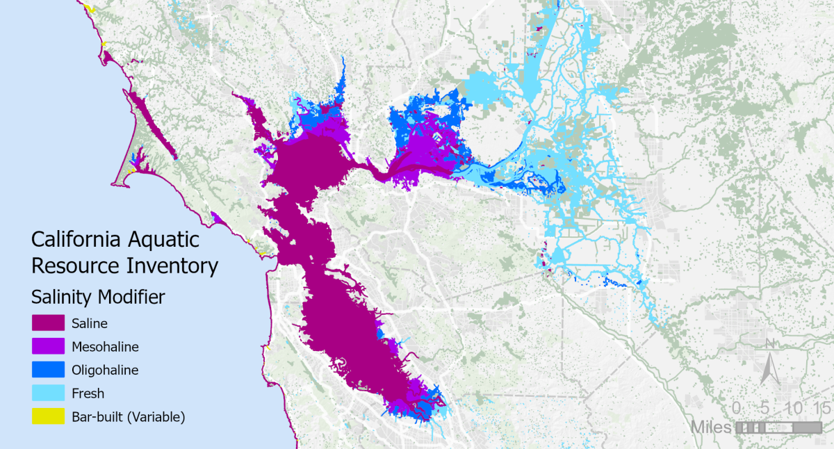
  • Adding a salinity attribute to the California Aquatic Resources Inventory in order to improve statewide estimation of coastal wetland greenhouse gas emissions

Funders


The Pew Charitable Trusts provided funding for this project, but Pew is not responsible for errors in this report and does not necessarily endorse its findings or conclusions.
 

Associated staff

Lydia Smith Vaughn, Cristina Grosso, Letitia Grenier, Alex Braud, Pete Kauhanen, Kendall Harris, Denise Walker, Ellen Plane, April Robinson

Dates

2021-2023

For more information about this project, please contact Lydia Smith Vaughn ([email protected])​

Overview

California’s AB 32 Climate Change Scoping Plan offers a roadmap to net zero through greenhouse gas emission reductions and removals across a variety of sectors. This document was developed by the California Air Resources Board and is updated every 5 years with up-to-date policies and sector-specific emissions reduction scenarios. The 2022 update of the Scoping Plan for Achieving Carbon Neutrality introduced a natural and working lands component, which presents land use scenarios to sequester carbon and reduce greenhouse gas emissions in the state’s forests, croplands, grasslands, shrublands/chaparral, developed areas, sparsely vegetated lands, and wetlands. 

Photo by Shira Bezalel
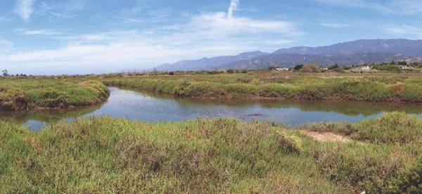
The Scoping Plan natural and working land scenarios include wetland restoration in the Sacramento-San Joaquin Delta, but omit blue carbon ecosystems found elsewhere in the state, such as California’s ~57,000 acres of salt marsh, tidal scrub-shrub wetland, and seagrass meadow. While not as extensive as the state’s forests and grasslands, these blue carbon ecosystems can sequester carbon more rapidly while providing unique resilience benefits to the state’s coastal communities and ecosystems. Filling this blue carbon gap will require integrating data and models from coastal wetlands that meet Scoping Plan standards for predicting and tracking emissions. Much of this science already exists, but additional synthesis is needed to develop statewide blue carbon quantification approaches and identify data or modeling gaps. To support broader inclusion of coastal wetlands in future Scoping Plan updates, we assembled a summary report, Leveraging Wetlands for a Better Climate Future, which:

  • Summarizes available coastal wetland datasets and quantification approaches including: wetland mapping, greenhouse gas and carbon accumulation data, and considerations regarding wetland vulnerability and resilience to sea-level rise.
  • Provides specific suggestions for coastal wetland restoration scenarios to include in the Scoping Plan, given available data.
  • Identifies key focus areas where additional science investment would improve state or regional blue carbon assessments.

Together, this information is intended to enable broader inclusion of coastal wetland blue carbon in future Scoping Plan updates and other state-level climate planning documents.

Major findings

  1. Sufficient information exists to incorporate an additional 57,000 acres of blue carbon ecosystems outside the Delta into the CARB Scoping Plan and other state and regional climate planning efforts.
  2. These currently unaccounted for coastal wetlands in California sequester an estimated 20,000 metric tons of carbon annually in tidal wetland and eelgrass sediments. 
  3. Including saline tidal wetlands and eelgrass in the Scoping Plan scenarios would increase the extent of existing wetlands by nearly 70% over the current Delta-only scenarios.
  4. Adding 18,000 acres of saline tidal wetland and 3,000 acres of eelgrass restoration in San Francisco Bay to the Scoping Plan proposed scenario would increase total wetland greenhouse gas benefits by 27,000 metric tons CO2e per year.
  5. Conserving existing coastal wetlands, in addition to restoring new ones, is critical for both climate protection and other services to people.
  6. Blue carbon ecosystems can contribute meaningfully to California’s climate goals even in their limited spatial footprint, given high rates of carbon accumulation and low rates of methane emissions in saline coastal wetlands. 
  7. Coastal wetlands offer numerous benefits in addition to climate regulation, which should be accounted for in climate resilience planning at state and regional levels. 
  8. Investment in repeat mapping efforts and biogeochemical data collection would improve the precision and scope of future blue carbon quantification.

Report authors

Lydia Smith Vaughn, Ellen Plane, Kendall Harris, April Robinson, Letitia Grenier

Download the report

Leveraging Wetlands for a Better Climate Future

Outreach and related efforts

Coordinated science is needed to develop datasets and models that work synergistically and meet the needs of CA regulators and other stakeholders looking to predict and track blue carbon benefits of wetland restoration. Building on our 2022 report, Leveraging Wetlands for a Better Climate Future, we are working to build connections and share project findings among other scientists, planners, and practitioners.

Quantifying and tracking California’s blue carbon resources requires accurate, repeatable mapping of coastal wetland types. The blue carbon budget for a given mapped wetland depends on the balance between carbon sequestration and methane emissions, which can vary widely across salinity gradients. Until recently, however, statewide wetlands mapping datasets have aggregated brackish and saline sites into a single “Estuarine” class, limiting efforts to quantify blue carbon exchanges at scale. To enable better estimation of coastal wetland greenhouse gas emissions, we have added a salinity attribute to coastal wetlands and estuarine waters in the California Aquatic Resources Inventory (CARI), a standardized statewide map of surface waters and related habitat types. This new CARI resource can be updated over time and used to inform broader questions related to climate impacts on wildlife habitat, water quality, agricultural productivity and other topics.

SalinityMap
Figure 1. Salinity Mapping in CARI symbolized for the larger SF Bay Area

The CARI salinity attribute assigns one of six salinity classes to estuarine polygons: Fresh (<0.5 ppt), Oligohaline (0.5-5 ppt), Mesohaline (5-18 ppt), Saline (>18 ppt), Bar-built (Variable), or Undefined. Salinity values are assigned according to a decision tree algorithm that uses vegetation mapping and published salinity measurements to determine the likely time-averaged salinity class for each estuarine CARI polygon. Methods and salinity maps were peer-reviewed prior to publication. The CARI salinity mapping methods brief provides a detailed overview of the decision tree methodology, underlying datasets, and uses and limitations of the resulting salinity attribute. 

For more information on CARI and to download the dataset and methodology, visit CARI's informational page

Explore the data in EcoAtlas.

The development of the scripts to apply the salinity modifier to CARI was funded by The Pew Charitable Trusts.

Working with other scientists, agency staff, and regional and state-level managers and planners, we are building alignment and capacity for blue carbon quantification through science synthesis, outreach, and mapping.

Dates: 
2021 to 2023
Funders: 
Programs and Focus Areas: 
Resilient Landscapes Program
Delta Science & Management
Carbon, Ecosystems & Climate
Location Information