Sarah Pearce

Sarah Pearce, MS
Senior Scientist
Clean Water Program
Watershed Monitoring and Modeling
Watershed Science & Management
Wetland Monitoring & Assessment
510-847-3976
Ms. Pearce received her B.S. in Geosciences in 1999 from Trinity University, San Antonio, Texas and her M.S. in Geomorphology from Lehigh University, Bethlehem, PA in 2001. Her master's research focused on the hydraulic geometry of ephemeral streams as they interacted with blind thrust faults and fault-propagation-folds associated with the continued uplift of the San Bernardino Mountains, Southern California. Ms. Pearce joined SFEI in 2001 and is currently working with the Watersheds and Wetlands group within the Resilient Landscapes program. Over the previous 20 years, she has carried out a number of projects focusing on fluvial geomorphic process in Bay Area streams and making interpretations of the data toward an understanding of the way beneficial uses such as sediment supply, salmonid habitat, bank stability, riparian function, flood control, water supply, and aesthetic value are influenced by land and water management in adjacent and upstream areas. Communication mechanisms for this policy and environmental management related scientific information have included direct interaction with environmental stewardship groups, development of high quality, peer-reviewed technical reports, and presentations at conferences and directly to local environmental managers. Ms. Pearce is also the training coordinator for the state for the California Rapid Assessment Method for wetlands (CRAM) (www.cramwetlands.org), and a member of the statewide Level 2 Committee which oversees CRAM and other rapid assessment methods. She is one of the most tenured practitioners and trainers in the state, with experience in all wetland types.
Related Projects, News, and Events
 California Aquatic Resource Inventory (CARI) (Project)
The California Aquatic Resources Inventory (CARI) is a Geographic Information System (GIS) based map of wetlands, streams, and riparian areas within California that is hosted online through EcoAtlas.
 Baylands Habitat Map 2020 (Project)
The Baylands Habitat Map 2020 (BHM 2020) updates the existing map of tidal marsh, tidal flats and diked baylands and incorporates the many changes in baylands distribution and abundance that have occurred over the last two decades. It also includes new information about land use and infrastructure that affects baylands restoration and management constraints and opportunities.
 Preparing for the Storm (Project)
Catalyzed by the extensive damages caused by the Winter 2016-2017 storms and the opportunity to align flood response with major habitat improvement, Preparing for the Storm is an innovative public-private partnership to improve watershed health and resilience in the Alameda Creek watershed.
 Sediment Solutions (Project)
Sediment Solutions is a timely and innovative project that builds on SFEI’s past work, operationalizing cutting-edge science to inform management approaches that take advantage of natural processes to provide more creek sediment to baylands, increase climate resilience, and enhance creek health. With study areas in North Bay, East Bay, and South Bay, the project will provide new guidance for management strategies that support flood risk management and ecosystem health benefits throughout the region.
 Enhanced Landscape Profile Modes in EcoAtlas deliver new insights (News)
EcoAtlas is a mapping and geographic data visualization tool that continues to evolve to meet emerging needs. The toolset now includes new data layers and summaries to support the watershed planning, tracking, and reporting needs for the state. Within EcoAtlas, the Landscape Profile Tool provides easy access to summaries and data visualizations on watershed characteristics, ecological condition, habitat connectivity, and coastal habitats for an area of interest.
 EcoAtlas Toolset Training and Outreach Plan (Project)
The California Wetland Monitoring Workgroup’s (CWMW) State Wetland and Riparian Area Monitoring Plan (WRAMP) requires information consistent with EPA’s Level 1‐2‐3 framework for monitoring and assessment of wetland and stream resources.
 Vision from the Skies: Using UAS Surveys to Monitor a Key Restoration Project (News)
At the McCosker Creek Restoration site, 3,000 linear feet of creek channel that previously had been flowing through underground culverts since the 1950s was daylighted and reconstructed. In addition, invasive and non native plants were removed and replaced with over 5,000 native plants. The restoration was also designed to support erosion control, and provide habitat for wildlife and aquatic species including rainbow trout, California red-legged frog and the Alameda whipsnake. This restoration work began in 2020 and concluded in 2023.
 Delta Aquatic Resource Inventory (Project)
DARI is the Delta Aquatic Resources Inventory of surface waters, wetlands and other aquatic resources in the Sacramento-San Joaquin Delta (Delta). The goal of the DARI project is to develop a geospatial inventory of aquatic resources that will be used as a common base map for the Delta. A similar mapping approach used to create the California Aquatic Resource Inventory (CARI) will be applied to provide a map of the aquatic resources and their associated attributes.
 Recently completed “Sycamore Alluvial Woodland Restoration and Enhancement Suitability Study” (News)
The “Sycamore Alluvial Woodland Restoration and Enhancement Suitability Study” addresses distribution and regeneration patterns and restoration strategies of sycamore alluvial woodland (SAW) habitat, a unique and relatively rare native vegetation community adapted to California’s intermittent rivers and streams. The report was produced by SFEI and H. T.
 Santa Clara Valley Water District Priority D5 Project's Watershed Condition Assessments (2010 to present) (Project)
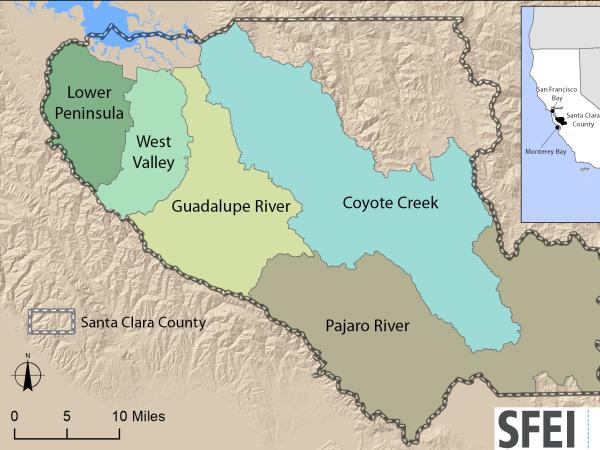
https://www.valleywater.org/project-updates/2012-d5-ecological-data-collection-and-analysisSFEI and the Santa Clara Valley Water District's (Valley Water) Priority D-5 Project have been conducting baseline ecological condition assessments in Santa Clara County, CA to characterize the distribution and abundance of stream and wetlands in five major watersheds, and to assess the overall ecological conditions of streams in the watersheds based on the California Rapic Assessment Method for streams (CRAM). The surveys employ the state's recommended Wetland and Riparian Area Monitoring Plan's watershed aproach that includes the use of GIS-base maps of aquatice resources (BAARI), and spatially-balanced ambient stream condition surveys using CRAM.
 Tahoe WRAMP Demonstration: Watershed Assessment (Project)
The Tahoe WRAMP Watershed Demonstration Project transferred statewide wetland monitoring and assessment tools to Sierra Nevada environmental agencies and organizations by conducting a pilot study that evaluated the distribution and abundance of wetlands, and the overall ecological condition of streams in two watersheds within the Lake Tahoe Basin.
 Get on the curve: Habitat Development Curves help determine the performance of on-the-ground projects (News)
How do you know if the ecological conditions of your wetland project are aligned with expected rates of improvement?
 Russian River Regional Monitoring Program: Comprehensive Basemap of Surface Waters and Riparian Areas (Project)
This project will build on existing projects funded by the CA State Water Board, Ocean Protection Council, Sonoma Ecology Center, and Sonoma County to produce a basemap of aquatic resources, using the updated Standard Operating Procedures (SOP) of the California Aquatic Resource Inventory (CARI), including at-risk waters and their riparian areas, to support the Russian River Regional Monitoring Program (R3MP). The main tasks of the project are to:
") Vernal Pool Habitat Restoration and Protection CRAM Tools for the Central Valley, CA (Project)
Vernal Pool Habitat Restoration and Protection CRAM Tools for the Central Valley, CA (Project)
The California Wetland Program Plan (WPP) seeks to strengthen protection for wetlands in many ways, including building capacity to track the net benefits of wetland policies and programs by employing aspects of the State’s Wetlands and Riparian Area Monitoring Plan (WRAMP).
 New Delta Habitat Map! (News)
The Delta Aquatic Resource Inventory (DARI) is a map of surface waters, wetlands and other aquatic resources in the Sacramento-San Joaquin Delta. A similar mapping approach used to create the Bay Area Aquatic Resource Inventory (BAARI) was applied to complete a consistent map across the larger San Francisco Estuary. Both DARI and BAARI are integrated into the California Aquatic Resource Inventory (CARI), which serves as the basemap in EcoAtlas.
 10-year Reassessment of Streams in the Coyote Creek Watershed (News)
SFEI and the Santa Clara Valley Water District just completed a report characterizing the amount, diversity, and distribution of aquatic resources in the Coyote Creek watershed, and the overall ecological conditions of streams in the watershed. The 2020 ambient stream condition reassessment survey used a watershed approach and the California Rapid Assessment Method (or CRAM) to compare the amount of stream miles in good, fair, and poor condition among the Hills and Valley regions as well as differences between a 2010 baseline survey and the 2020 reassessment.
 EcoAtlas (Project)
EcoAtlas is a set of tools for generating, assembling, storing, visualizing, sharing, and reporting environmental data and information.
 Russian River Watershed Projects at the San Francisco Estuary Institute (Project)
Our projects in the Russian River Watershed help us to understand our past, understand our present, and envision our future. Learn more about what SFEI is doing in partnership with others to advance our scientific understanding of this valuable landscape.
 Sediment for Survival report released (News)
SFEI worked with local, state, and federal science experts to develop the new Sediment for Survival report. The report provides a regional sediment strategy aimed at examining the future of sediment in the Bay and informing sediment management for the resilience of tidal marshes and tidal flats to climate change.
 “Towards a Coarse Sediment Strategy for the Bay Area” completed! (News)
The release of “Towards a Coarse Sediment Strategy for the Bay Area” represents a step forward towards beneficially reusing coarse flood control channel sediment by outlining reuse challenges, and identifying incentives for participation and potential solutions.
- 1 of 3
- next ›