Historical Wetlands of the Southern California Coast: An Atlas of US Coast Survey T-Sheets 1851-1889

This project is the first regional assessment of the relative distribution and abundance of different wetland habitat types along the historical Southern California coastline ("South Coast"). The extent of South Coast wetlands has been dramatically reduced over the past 150 years, and there are now many large-scale efforts to recover some of these environments. Scientists, managers, and the public face challenging decisions about which areas should be acquired; what kinds of habitats should be restored where; and how these estuarine systems can grow and adapt over time to support target habitats and functions.
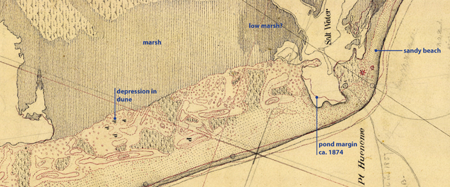
The maps of the US Coast Survey (commonly referred to as "T-sheets") are the single most important data source for understanding the physical and ecological characteristics of the US shoreline prior to Euro-American modification. Their depictions of coastal wetlands and estuaries prior to major development are valuable tools for coastal zone planning and estuary management, but are rarely accessible to scientists and managers. In this project we acquired, interpreted, digitized, and performed initial regional analysis of 26 T-sheets for the Southern California coast. This new body of information is available through a project report (the "T-sheet Atlas"), GIS database, and interactive website (CalTsheets.org).
Major findings of the study include the following.
• There were about 20,000 ha (49,000 acres) of estuarine habitats along the Southern California coast prior to modern development.
• The most common estuarine habitat type was vegetated wetlands (i.e. salt or brackish marsh), followed by subtidal waters and intertidal flats. Salt flat and open water were smaller components of the regional habitat mosaic.
• The subregional distribution of estuarine habitat types was heterogeneous. For example, subtidal waters predominated in one subregion – Mission Bay/Silver Strand. Vegetated wetlands were the dominant habitat type in all other subregions. Salt flat was found predominantly in the San Pedro and Oceanside regions.
• Most of the estuarine habitat area of Southern California was found in a relatively small number of systems. The top 21 systems accounted for 98% of the estuarine habitat area.
• Distinct habitat mixes can be identified among these systems, suggesting a preliminary set of regional coastal estuarine patterns or archetypes. The most common archetype was broad tidal marshes with adjacent intertidal flats and smaller areas of subtidal water, open water, and salt flat. Several other patterns were observed in different physiographic settings.
For more information about the study, please consult the T-sheet Atlas, which explores the technical information these data provide, how we compiled it, the limitations and opportunities for its use. To zoom in and out of the T-sheets themselves, overlay the GIS habitat map, and view these datasets over contemporary aerial imagery, please visit the T-sheet website.
The T-sheet Atlas is a component of the Ventura and South Coast Wetlands Historical Ecology Study.
Phase 2 of this project, completed in 2014, included acquisition of the remaining T-sheets for the South Coast, which include small systems associated with steep topography, and a Change Analysis comparing historical and contemporary patterns of wetland distribution.
Collaborators
Southern California Coastal Water Research Project (SCCWRP)
California State University Northridge (CSUN)
Funders
California Coastal Conservancy
Los Angeles Regional Water Quality Control Board
Project Status
Completed January 2011
Download the Report
high resolution PDFs (for printing)
Historical Wetlands of the Southern California Coast: An Atlas of US Coast Survey T-sheets, 1851-1889 (202 MB)
Appendix B: additional t-sheets with contemporary overlays (197 MB)
low resolution PDFs (for screen viewing)
Historical Wetlands of the Southern California Coast: An Atlas of US Coast Survey T-sheets, 1851-1889 (5.42 MB)
Appendix B: additional t-sheets with contemporary overlays (4.95 MB)
T-sheet website (CalTsheets.org)
Download T-sheet data
Dates:
2009
Project Site:
Programs and Focus Areas:
Environmental Informatics Program
Resilient Landscapes Program
Historical Ecology
Shoreline Resilience
Related Projects, News, and Events:
 Ventura County Historical Ecology Study (Project)
This project investigated the historical ecological patterns and hydrological dynamics of most of lowland Ventura County.
 Historical Wetlands of the Southern California Coast Phase 2: Historical Extent and Change Over Time (Project)
This project builds on earlier efforts to provide comprehensive analysis of the 40 T-sheets that cover the southern California Bight (SCB) from Point Conception to the US-Mexico border. High quality scans of the original T-sheets produced between 1851 and 1889 were obtained along with the surveyor notes.
 North San Diego County Lagoons Historical Ecology Study (Project)
The Northern San Diego County Lagoons Historical Ecology Investigation draws on hundreds of historical documents to analyze and reconstruct historical landscape conditions for six northern San Diego County estuaries prior to the major modifications of the late 19th and 20th centuries.