Assessing Five Watersheds in Santa Clara County
May 7, 2020
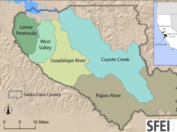
Since 2010, SFEI has been working with the Santa Clara Valley Water District (Valley Water) to complete baseline watershed assessments to characterize the distribution, abundance, and diversity of streams and other wetland types within Santa Clara County. This work performs a critical function in informing planning efforts for riverine restoration, mitigation, and performance tracking.
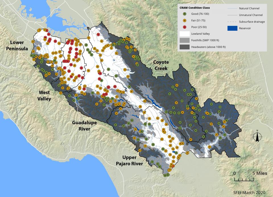
In particular, SFEI has been working in partnership with Valley Water to assess the overall ecological condition of streams in the region using EPA’s recommended probability based ambient survey design and the California Rapid Assessment Method (CRAM) with 325 field assessments distributed across the region. This project employed the wetland and riparian area monitoring framework recommended by EPA and endorsed by the California Water Quality Monitoring Council, which uses the EcoAtlas toolset including the California Aquatic Resources Inventory (CARI), CRAM, and other environmental data. SFEI recently completed the five watershed synthesis report (March 2020). This report includes examples for applying CRAM to various elements, including project and mitigation planning, as well as performance tracking within a watershed context.
Valley Water is using EcoAtlas as the public access point for the Project’s ambient survey CRAM assessment results, and individual watershed ambient survey cumulative distribution function plots that characterize the proportion of stream resources in good, fair, or poor condition (through the Landscape Profile tool). This project was funded by Valley Water’s Safe, Clean Water and Natural Flood Protection Program: Priority D.5 Ecological Data Collection and Analysis Project.
Other Contributors:
Lisa Porcella
Doug Titus
Zooey Diggory
Programs and Focus Areas:
Environmental Informatics Program
Resilient Landscapes Program
Wetland Monitoring & Assessment
Watershed Science & Management
Related Projects, News, and Events:
 California Aquatic Resource Inventory (CARI) (Project)
The California Aquatic Resources Inventory (CARI) is a Geographic Information System (GIS) based map of wetlands, streams, and riparian areas within California that is hosted online through EcoAtlas.
 Santa Clara Valley Water District Priority D5 Project's Watershed Condition Assessments (2010 to present) (Project)
https://www.valleywater.org/project-updates/2012-d5-ecological-data-collection-and-analysisSFEI and the Santa Clara Valley Water District's (Valley Water) Priority D-5 Project have been conducting baseline ecological condition assessments in Santa Clara County, CA to characterize the distribution and abundance of stream and wetlands in five major watersheds, and to assess the overall ecological conditions of streams in the watersheds based on the California Rapic Assessment Method for streams (CRAM). The surveys employ the state's recommended Wetland and Riparian Area Monitoring Plan's watershed aproach that includes the use of GIS-base maps of aquatice resources (BAARI), and spatially-balanced ambient stream condition surveys using CRAM.
 EcoAtlas (Project)
EcoAtlas is a set of tools for generating, assembling, storing, visualizing, sharing, and reporting environmental data and information.
 California Rapid Assessment Method (CRAM) (Project)
CRAM is a standardized, scientifically defensible rapid assessment method for monitoring the ecological conditions of wetlands throughout California. Because it is standardized, one can compare ecological conditions of wetlands locally, regionally and statewide.