Russian River Watershed Projects at the San Francisco Estuary Institute

Download the flyer relating all of these materials.
*For links to these reports, go to RussianRiver.SFEI.org
|
Understanding the Present |
|---|
|
Dates:
2015
Partners:
Russian River Watershed Association
Laguna de Santa Rosa Foundation
Sonoma Ecology Center
Sonoma Co. Ag. Preservation & Open Space Dist.
Sonoma County Water Agency
Sonoma County Resource Conservation District
North Coast Regional Water Quality Control Board
California State Water Resources Control Board
California Department of Fish and Wildlife
U.S. Environmental Protection Agency
U.S. Bureau of Ocean Energy Management
U.S. National Marine Fisheries Service
California Natural Resources Agency
Associated Staff:
Associated Data:
Programs and Focus Areas:
Clean Water Program
Environmental Informatics Program
Geographic Information Systems
Software Engineering
Resilient Landscapes Program
Historical Ecology
Wetland Monitoring & Assessment
Watershed Science & Management
| Attachment | Size |
|---|---|
| 1.19 MB |
Related Projects, News, and Events:
 Laguna de Santa Rosa Historical Ecology Initiative (Project)
The Laguna de Santa Rosa (Laguna) watershed spans 256 square miles and supports a unique complex of biologically diverse ecosystems. Containing the urban centers of Santa Rosa, Sebastopol, Cotati, Rohnert Park, and Windsor, the Laguna watershed encompasses one of the largest floodplains in California. Historically the Laguna watershed supported a diverse ecosystem consisting of oak savanna/vernal pool complexes, riparian forest, emergent and off channel wetlands, and open water.
The Riparian Zone Estimator Tool (RipZET) is a decision support tool developed by the San Francisco Estuary Institute and Aquatic Science Center for the California Riparian Habitat Joint Venture and the California Water Resources Control Board to assist in the visualization and characterization of riparian areas in the watershed context.
 GreenPlan-IT (Project)
Green infrastructure (GI), such as permeable pavement, rain gardens, tree-well planters, or bioswales, can be used as cost-effective, resilient approaches to managing stormwater at its source while delivering environmental, social, and economic benefits for your community. GreenPlan-IT is a versatile open-source toolset that helps aid municipalities with their efforts to plan and evaluate the placement of green infrastructure in the landscape and track the effectiveness of these installations in reducing stormwater run-off, PCB, and mercury in receiving waters.
 Lower Laguna de Santa Rosa and Mark West Creek: Changes in Historical Channel Alignment (Project)
Over the past century and a half, the hydrology of the Laguna de Santa Rosa watershed has been altered by a variety land use changes, including urbanization, agricultural development, draining and filling of wetlands, and channelization of streams. These changes have impacted the function of the Laguna and Mark West Creek and contributed to a range of contemporary management problems, including habitat degradation, impaired water quality, altered sediment dynamics, salmonid stranding, flooding, and trash accumulation.
 Santa Rosa Plain Wetlands Profile: A Demonstration of WRAMP (Project)
The Santa Rosa Plain WRAMP project demonstrated the use of the State’s standardized monitoring and assessment tools in a North Coast watershed setting and described how the results can support watershed based management and planning decisions to protect and manage the state’s wetlands at a landscape scale.
 Historical Ecology and Landscape Change in the Central Laguna de Santa Rosa (Project)
This study synthesizes a diverse array of data to examine the ecological patterns, ecosystem functions, and hydrology that characterized a central portion of the Laguna de Santa Rosa during the mid-19th century, and to analyze landscape changes over the past 150 years. The primary purpose of this study was to help guide restoration actions and other measures aimed at reducing nutrient loads within this portion of the Laguna de Santa Rosa watershed.
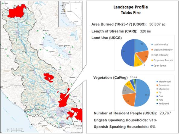 Russian River Watershed Atlas helps track and coordinate post-fire activities (News)
Fire recovery in the Russian River Watershed will benefit from a common online platform for compiling, visualizing, and interpreting many kinds of environmental data available from diverse federal, state, regional, and local sources. Providing such a platform is one objective of the Russian River Regional Monitoring Program (R3MP).
 North Coast WRAMP Demonstration: Mapping Standards (Project)
The North Coast WRAMP Demonstation Project focused on mapping and assessing the condition of aquatic resources within the Santa Rosa Plain, CA using GIS based mapping protocols consistent with BAARI. A new regional Mapping Standards Methodology (NCARI) was developed to add regional wetland types not covered in BAARI's documentation.