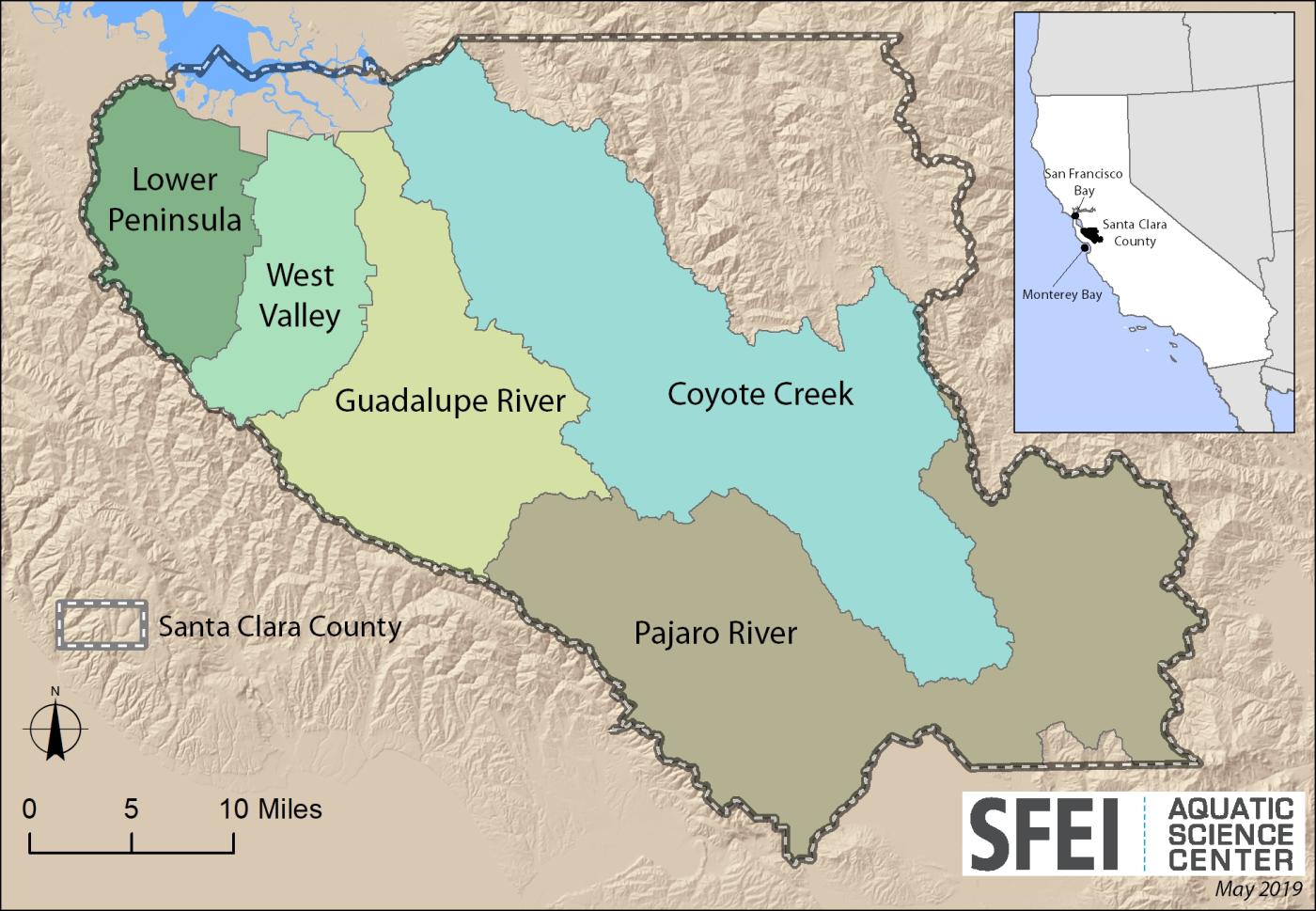
The Santa Clara Valley Water District’s (Valley Water) Safe, Clean Water and Natural Flood Protection Program has many priorities, including eight projects under Priority D for “restoring and protecting vital wildlife habitat and providing opportunities for increased access to trails and open space". In 2010, during the development of the foundational roots of the Priority D5 Project: Ecological Data Collection and Analysis effort, Valley Water implemented a watershed approach to environmental monitoring and assessment using the State's Wetland and Riparian Area Monitoring Plan’s (WRAMP) 3-level framework recommended by the United States Environmental Protection Agency (USEPA). Since then the D5 Project completed five watershed-wide baseline assessments characterizing the amount, distribution, and diversity of aquatic resource in five major watersheds within Santa Clara County, and characterizing the overall ecological conditions of streams in each watershed employing CRAM. The purpose of these assessments is to align the collection and analysis of ecological data with the needs of water resource decision-makers by collecting data that address specific management questions developed by Valley Water's resource managers. Each watershed will be reassessed every 10-15 years to begin to track change over time.
The D5 Project's watershed survey's employ several free, online standardized monitoring and assessment tools developed for statewide use to support the State Wetland Definition and Procedures for Discharges of Dredged or Fill Material to Waters of the State including: the California Aquatic Resources Inventory (CARI, the statewide GIS-based aquatic resource basemap), California Rapid Assessment Method (CRAM) for streams, and EcoAtlas (an interactive, online data management, visualization, and public access website).
Progress to Date and Report Links:
- Baseline watershed condition assessments were completed between 2010 and 2018 (individual watershed baseline reports can be found at the following links)
- Baseline watershed condition assessments also included the development of the study area extents and survey design. This information was either included in the condition assessment reports (listed above) or as standalone reports found at the following links:
- Upper Pajaro River Watershed and Lower Peninsula Watershed (Study Design and Survey Design)
- West Valley Watershed (Study and Survey Design)
- The Santa Clara County Five Watersheds Assessment Synthesis Report was completed in 2020, and presents the baseline conditions and compares ecological conditions among the five watersheds
- 10-Year Watershed Reassessments starting in 2020 to track change over time
- Coyote Creek Watershed 10-Year Reassessment was completed in 2020:
- Guadalupe River Watershed 10-Year Reassessment was completed in 2022:
- Upper Pajaro River Watershed 10-Year Reassessment was completed in 2025:
- A Watershed Approach to Restoration and Mitigation Planning, Monitoring, and Assessment Based on the Wetland and Riparian Area Monitoring Plan (WRAMP) - Llagas Creek Flood Control Project Example
- Restoration Project Monitoring
The CRAM field assessments are coordinated by SFEI's lead CRAM Trainer and Practioner, Sarah Pearce, who is the overall logistics lead and QA officer. The field assessments have been completed by a large team of trained CRAM Practioners from SFEI, Valley Water, Michael Baker International, ICF, and the Central Coast Wetlands Group (CCWG). The Project would like to acknowlege and thank Don Stevens, Tom Kincaid, and Tony Olsen of the USEPA for their advise and review on the watershed survey designs that employed the Generally Random Tesselated Stratified (GRTS) design and analysis tools (spsurvey in R). The CRAM ambient survey field assessment results for all the watersheds have been uploaded to the statewide CRAM database (www.cramwetlands.org) and are available online through the EcoAtlas data visualization, access, and summary tools (www.ecoatlas.org).








Other Individual Contributors


This report synthesizes the baseline assessments for Santa Clara County’s five watersheds to present similarities, differences, and compare ecological condition in streams across watersheds and their subregions, San Francisco Bay-Delta ecoregion, and statewide based on CRAM.

The baseline survey of ecological condition of streams within the Guadalupe River watershed was completed in 2012, and this reassessment survey was completed ten years later in 2022.
In 2015 The Santa Clara Valley Water District and it's consultants conducted a watershed wide survey to characterize the distribution and abundance of the aquatic resources within the upper Pajaro River watershed wtihin Santa Clara County, CA based on available GIS datasets, and to asse
This report describes baseline information about the amount and distribution of aquatic resources, and evaluates the overall ecological conditions of streams using the California Rapid Assessment Method (CRAM), for the West Valley watershed in Santa Clara County; consisting of Sunnyvale East and
The Santa Clara Valley Water District’s (Valley Water) Upper Llagas Creek Flood Protection Project (Project) aims to increase flood protection within the City of Morgan Hill and surrounding unincorporated areas.
This report describes the amount and distribution of aquatic resources in the Coyote Creek watershed, Santa Clara County, California, and presents the first reassessment of stream ecosystem conditions using a watershed approach and the California Rapid Assessment Method (CRAM).
This technical report describes the ten-year ambient stream condition reassessment survey design and monitoring plan (or strategy) for the Coyote Creek watershed.
The Santa Clara Valley Water District (Valley Water) collects data on the health, or overall ecological condition, of streams across its five watersheds as a part of its voter-approved Safe, Clean Water and Natural Flood Protection Program.

The Santa Clara Valley Water District's Watching Our Watersheds (WOW) project has adapted Historical Ecology data into Google Earth (KMZ) format.