Library
Our library features many hundreds of entries.
To search among them, click "Search" below to pull down options, including filtering by document type, author, year, and keyword.
Find these options under "Show only items where." Or you can also sort by author, title, type, and year clicking the headings below.
2024. 2021 Update to Copper Rolling Average. SFEI Contribution No. 1164. San Francisco Estuary Institute: Richmond, CA.
2024. 2021 Update to Cyanide Rolling Averages. San Francisco Estuary Institute: Richmond, CA.
2024. 2024 Quality Assurance Program Plan for The Regional Monitoring Program for Water Quality in San Francisco Bay. SFEI Contribution No. 1169. San Francisco Estuary Institute: Richmond, CA.
2024. Development of Semi-Empirical Light Extinction Estimates for Biogeochemical Modeling Applications in San Francisco Bay. SFEI Contribution No. 1177. San Francisco Estuary Institute: Richmond, CA.
2024. Investigation of quaternary ammonium compounds (QACs) in wastewater effluent, influent, biosolids and environmental matrices in San Francisco Bay. SFEI Contribution No. 1196. San Francisco Estuary Institute: Richmond, CA.
Quaternary ammonium compounds (QACs) are surfactants widely used in a variety of consumer products, particularly as antimicrobials. The COVID-19 pandemic has increased use of products containing QACs. This is of concern because QACs can be toxic to aquatic life at low concentrations. This study was undertaken to evaluate the concentrations of 21 QACs in municipal wastewater influent, effluent, and biosolids from three treatment plants in the San Francisco Bay Area. The QACs detected in wastewater influent in the highest concentrations are those commonly used as antimicrobials in disinfectant products, indicating that disinfectants are likely a large source of QACs to wastewater. While wastewater treatment removed QACs in the aqueous phase, as evidenced by much lower concentrations in effluents than influents, total levels present in treated effluent were still on the order of hundreds of ng/L to low μg/L. High amounts of QACs were found sorbed to biosolids, which could provide another environmental release route.
QACs were also observed in San Francisco Bay water, sediment, and urban stormwater runoff samples collected as part of ongoing monitoring by the Regional Monitoring Program for Water Quality in San Francisco Bay (RMP). Wastewater effluents and stormwater runoff are both pathways for QACs to enter San Francisco Bay. We classify QACs as a Possible Concern for the Bay in the RMP’s tiered risk-based framework for emerging contaminants, based primarily on the limited number of ambient Bay samples analyzed, and recommend additional screening of Bay water in the future.
2024. Managed wetlands for climate action: potential greenhouse gas and subsidence mitigation in the Sacramento-San Joaquin Delta. In Press.
2024. Microplastics Monitoring and Science Strategy for San Francisco Bay 2024 Revision. SFEI Contribution No. 1144. San Francisco Estuary Institute: Richmond, CA.
2024. Modeling Stormwater Loads of Contaminants of Emerging Concern: Literature Review and Recommendations. SFEI Contribution No. 1131. San Francisco Estuary Institute: Richmond, CA.
2024. Multi Year Plan 2024. SFEI Contribution No. 1167. San Francisco Estuary Institute: Richmond, CA.
The purpose of this document is to guide efforts and summarize plans developed within the RMP. The intended audience includes representatives of the many organizations who directly participate in the Program. This document will also be useful for individuals who are not directly involved with the RMP but are interested in an overview of the Program and where it is heading.
The organization of this Multi-Year Plan parallels the RMP planning process (Figure 2). Section 1 presents the long-term management plans of the agencies responsible for managing water quality in the Bay and the overarching management questions that guide the Program. The agencies’ long-term management plans provide the foundation for RMP planning (Figure 2). In order to turn the plans into effective actions, the RMP distills prioritized lists of management questions that need to be answered (Page 8). The prioritized management questions then serve as a roadmap for scientists on the Technical Review Committee, workgroups, and strategy teams to plan and implement scientific studies to address the most urgent information needs. This information sharpens the focus on management actions that will most effectively and efficiently
2024. Patterns in bird and pollinator occupancy and richness in a mosaic of urban office parks across scales and seasons. Ecology and Evolution 14 (3).

Urbanization is a leading cause of global biodiversity loss, yet cities can provide resources required by many species throughout the year. In recognition of this, cities around the world are adopting strategies to increase biodiversity. These efforts would benefit from a robust understanding of how natural and enhanced features in urbanized areas influence various taxa. We explored seasonal and spatial patterns in occupancy and taxonomic richness of birds and pollinators among office parks in Santa Clara County, California, USA, where natural features and commercial landscaping have generated variation in conditions across scales. We surveyed birds and insect pollinators, estimated multi-species occupancy and species richness, and found that spatial scale (local, neighborhood, and landscape scale), season, and urban sensitivity were all important for understanding how communities occupied sites. Features at the landscape (distance to streams or baylands) and local scale (tree canopy, shrub, or impervious cover) were the strongest predictors of avian occupancy in all seasons. Pollinator richness was influenced by local tree canopy and impervious cover in spring, and distance to baylands in early and late summer. We then predicted the relative contributions of different spatial scales to annual bird species richness by simulating “good” and “poor” quality sites based on influential covariates returned by the previous models. Shifting from poor to good quality conditions locally increased annual avian richness by up to 6.8 species with no predicted effect on the quality of the neighborhood. Conversely, sites of poor local and neighborhood scale quality in good-quality landscapes were predicted to harbor 11.5 more species than sites of good local- and neighborhood-scale quality in poor-quality landscapes. Finally, more urban-sensitive bird species were gained at good quality sites relative to urban tolerant species, suggesting that urban natural features at the local and landscape scales disproportionately benefited them.
2024. Petaluma River Watershed Contemporary Riparian Condition Assessment. Petaluma River Watershed Contemporary Riparian Condition Assessment. SFEI Contribution No. 1160. San Francisco Estuary Institute: Richmond, CA.
2024. Robertson Park and Medeiros Parkway sUAS Surveys for the Sycamore Pilot Implementation Project. Prepared for Zone 7 Water Agency and US Environmental Protection Agency’s Water Quality Improvement Fund. In collaboration with San Francisco Estuary Institute.
This memo summarizes the use of small Unoccupied Aerial Systems (sUAS) to survey Robertson Park and Medeiros Parkway and analysis of how this type of technology can be used to support site scale level mapping.
2024. Selenium Concentrations in Water and Clams in North San Francisco Bay, 2019-2020. SFEI Contribution No. 1116. San Francisco Estuary Institute: Richmond, CA.
The Regional Monitoring Program for Water Quality in San Francisco Bay (RMP) started implementing a new design for North Bay selenium (Se) sampling in 2019 after a long-term USGS program was terminated in 2017. To determine if the RMP sampling and analysis methods are producing similar results to the USGS study, we compared Se concentrations and stable isotope values in clams at two stations in Suisun Bay, California, that were sampled by the USGS long-term monitoring program from 1995-2010 and the RMP in 2019-2020. We also compared Se concentrations in water (dissolved and particulate) from the RMP Status and Trends sampling in Suisun Bay (1993-2019) to the samples collected as part of this study.
Spatial patterns in clam Se concentrations between the USGS and RMP studies were similar, with lower concentrations at Station 4.1 (Suisun Bay) than at Station 8.1 (Carquinez Strait). Se concentrations at both stations were consistently lower for the RMP samples than those reported in the long-term USGS dataset. Stable isotope values for δ13C and δ15N were similar for the USGS and RMP samples with δ13C and δ15N more enriched at Station 8.1 than 4.1. However, there was not close alignment of the RMP samples to the USGS long-term average, particularly at Station 8.1. Average dissolved Se concentrations in water were consistently lower than the long-term average at Station 4.1 and similar to or above the long-term RMP Status and Trends (S&T) average at Station 8.1. Particulate Se concentrations at Stations 4.1 and 8.1 were nearly one-third of the long-term S&T average in Suisun Bay, likely due to a change in methods for calculating particulate Se.
Additional information is needed to evaluate whether the lower Se concentrations measured in clams as part of the RMP study could be suggestive of declining Se concentrations in North Bay clams between 2010 and 2019 or an artifact of the new analytical lab. Additional data from samples collected by the USGS from 2011-2017 should be examined to fill the gap between the datasets. Continued RMP monitoring will also be valuable in evaluating long-term trends.
2024. Water Year 2024 RMP Near-Field Water Sampling and Analysis Plan. SFEI Contribution No. 1154.
This report details sampling and analysis plans associated with the pilot near-field water sampling for the Regional Monitoring Program for Water Quality in San Francisco Bay (RMP). The RMP added a pilot effort to the Status & Trends (S&T) Program to quantify contaminants of emerging concern (CECs) in Bay water in areas near (“near-field” of) expected loading pathways during or shortly after storm events and during the dry season. For the first year of the pilot (Water Year 2022), the near-field design included three targeted, near-field stations and four ambient Bay stations. A fourth near-field station was added in subsequent years. Samples are collected at these stations during or shortly after two storm events, and once in the dry season. The analytes being measured include bisphenols, organophosphate esters (OPEs), PFAS-target, PFAS-TOP, and a suite of stormwater CECs.
2024. Where the rubber meets the road: Emerging environmental impacts of tire wear particles and their chemical cocktails. Science of the Total Environment 927.
About 3 billion new tires are produced each year and about 800 million tires become waste annually. Global dependence upon tires produced from natural rubber and petroleum-based compounds represents a persistent and complex environmental problem with only partial and often-times, ineffective solutions. Tire emissions may be in the form of whole tires, tire particles, and chemical compounds, each of which is transported through various atmospheric, terrestrial, and aquatic routes in the natural and built environments. Production and use of tires generates multiple heavy metals, plastics, PAH's, and other compounds that can be toxic alone or as chemical cocktails. Used tires require storage space, are energy intensive to recycle, and generally have few post-wear uses that are not also potential sources of pollutants (e.g., crumb rubber, pavements, burning). Tire particles emitted during use are a major component of microplastics in urban runoff and a source of unique and highly potent toxic substances. Thus, tires represent a ubiquitous and complex pollutant that requires a comprehensive examination to develop effective management and remediation. We approach the issue of tire pollution holistically by examining the life cycle of tires across production, emissions, recycling, and disposal. In this paper, we synthesize recent research and data about the environmental and human health risks associated with the production, use, and disposal of tires and discuss gaps in our knowledge about fate and transport, as well as the toxicology of tire particles and chemical leachates. We examine potential management and remediation approaches for addressing exposure risks across the life cycle of tires. We consider tires as pollutants across three levels: tires in their whole state, as particulates, and as a mixture of chemical cocktails. Finally, we discuss information gaps in our understanding of tires as a pollutant and outline key questions to improve our knowledge and ability to manage and remediate tire pollution.
2023. 2023 Bay Prey Fish and Near-field / Margins Sediment Sampling and Analysis Plan. SFEI Contribution No. 1141. San Francisco Estuary Institute: Richmond, CA.
This is a sampling and analysis plan for the Bay Status and Trends (S&T) Prey Fish and Near-field / Margins Sediment monitoring for the Regional Monitoring Program for Water Quality in San Francisco Bay (RMP). Bay margins are defined by the RMP as extending from Mean Higher High Water (MHHW) to 1 foot below Mean Lower Low Water (MLLW). These mud flats and adjacent shallow areas of the Bay are productive and highly utilized by biota of interest (humans and wildlife). Near-field stations are located near watershed inputs in the Bay. Prey fish are a key matrix to monitoring the status and impacts of contaminants, especially near margin areas where they have shown strong contamination signals in previous RMP studies. This monitoring design provides a spatially-distributed characterization of contaminant concentrations in fish and sediment found within the margins of Central Bay, South Bay, and Lower South Bay. This study builds on previous S&T efforts to characterize surface sediment contamination across the Bay while piloting routine monitoring of prey fish. Additional samples outside of S&T will be collected for special studies. A subset of samples will be archived for potential future analysis of emerging contaminants or other analyte groups.
2023. 2023 RMP Dry Season Water Cruise Plan. SFEI Contribution No. 1139. San Francisco Estuary Institute: Richmond, CA.
This report details plans associated with the 2023 Regional Monitoring Program for Water Quality in the San Francisco Estuary (RMP) water cruise. The RMP water sampling program was redesigned in 2002 to adopt a randomized sampling design at thirty-one stations in place of the twenty-six base program stations sampled previously. In 2007, the number of stations was decreased to twenty-two stations, and it remains as such for 2023. The analytes for 2023 are based on the Status and Trends (S&T) Review process that started in 2020.
2023. 2023 RMP Margins & Nearfield Sediment and Prey Fish Cruise Report. SFEI Contribution No. 1190. San Jose State University Research Foundation: Moss Landing, CA.
This report contains information on the summer 2023 field sampling efforts conducted by the San Jose State University Research Foundation’s (SJSURF) Marine Pollution Studies Lab at Moss Landing Marine Labs (MPSL-MLML) in support of the Regional Monitoring Program’s (RMP) Central and South Bay Near-field and Margins chemical contaminant study. The work was contracted through the San Francisco Estuary Institute (SFEI) to SJSURF to collect sediment and prey fish tissue samples.
This report includes sample collections over a four week period (August 21st through September 14th) encompassing four trips. A total of 38 sediment and 12 prey fish sites were sampled, three of which included collecting duplicate sediment samples (Appendix A). Detailed sample counts and protocols can be found in the “2023 Bay Prey Fish and Near-field / Margins Sediment Sampling and Analysis Plan” prepared by SFEI.
2023. 2023 RMP Sediment Cruise Report. SFEI Contribution No. 1168. Applied Marine Sciences: Livermore, CA.
This report outlines details from the annual Regional Monitoring Program for Water Quality in the San Francisco Estuary (RMP) sediment cruise, conducted July 24 – 27, 2023. The Regional Monitoring Program conducts routine monitoring of water, sediment and biological tissue. For 2023, sampling operations entailed dry season collections at 16 RMP sediment sampling sites.
2023. 2023 RMP Sediment Cruise Sampling and Analysis Plan. SFEI Contribution No. 1138. San Francisco Estuary Institute: Richmond, CA.
This report details plans associated with the Regional Monitoring Program for Water Quality in the San Francisco Estuary (RMP) deep bay sediment cruise. The RMP, through the Status and Trends monitoring program, conducts routine monitoring of water, sediment and biological tissue. Deep bay stations (water depth lower than 1 foot below MLLW) have been sampled for the Status and Trends sediment program since its inception. The current monitoring design (reflective of changes made to the Program through the Status and Trends Review process) calls for sampling frequency of deep bay sediment for CECs, PBDEs, and ancillary analytes every five years during the dry season. Every ten years, metals, PAHs, and PCBs will also be sampled. For 2023, sampling operations will entail dry season sample collection at 16 RMP sediment sampling stations for CECs, PBDEs, and ancillary analytes in Central Bay, South Bay, and Lower South Bay.
2023. 2023 RMP Update. SFEI Contribution No. 1148. San Francisco Estuary Institute: Richmond, CA.
The overarching goal of the Regional Monitoring Program for Water Quality in San Francisco Bay (RMP) is to answer the highest priority scientific questions faced by managers of Bay water quality. The RMP is an innovative collaboration between the San Francisco Bay Regional Water Quality Control Board, the regulated discharger community, the San Francisco Estuary Institute, and many other scientists and interested parties. The purpose of this document is to provide a concise overview of recent RMP activities and findings, and a look ahead to significant products anticipated in the next two years. The report includes:
- a brief summary of some of the most noteworthy findings of this multifaceted Program;
- a description of the management context that guides the Program; and
- a summary of progress to date and future plans for addressing priority water quality topics.
2023. 2023 RMP Water Cruise Report. SFEI Contribution No. 1191. Applied Marine Sciences: Livermore, CA.
2023. 2024 Detailed Workplan and Budget.
In 2024, the Regional Monitoring Program for Water Quality in San Francisco Bay (RMP) is entering its 32nd year of collecting data and communicating information to support water quality management decisions. This Detailed Workplan and Budget describes the activities that will be completed in 2024, the proposed funding levels, and the deliverables for each task.
The planned revenue from RMP fees for 2024 is $4,156k, with additional supplemental fees of $339k from municipal wastewater and $100k from municipal stormwater bringing the total revenue to $4,596k. The expected revenue is $5,216k as shown in Table 1 and Figures 1-2, which is reduced by $200k to account for the lower volume of dredged sediment being disposed of in the Bay, per the Long-Term Management Strategy (LTMS) plan. The $200k figure is a placeholder and the dredger contribution will be updated when we receive the final in-Bay dredge disposal volumes for calendar year 2023 (typically in March of the following year). The majority of the expenses in 2024 (71%) will be for Status and Trends monitoring and special studies (Tasks 6-7). The cost for running the RMP (Tasks 1-5) is $115k higher in 2024 than 2023 and funding allocations have been shifted slightly within each subtask.
2023. Adding Salinity Modifiers to CARI - Methods Brief. San Francisco Estuary Institute.
2023. Arroyo de la Laguna: Reach-based Geomorphic Evaluation. Prepared for the US Environmental Protection Agency’s Water Quality Improvement Fund. SFEI Contribution No. 936. San Francisco Estuary Institute: Richmond, CA.
 The reach of ADLL between the Arroyo Del Valle confluence (at the Interstate 680 crossing) and Verona Road is currently experiencing significant changes to its channel morphology, namely incision and widening, leading to bank erosion and bank failures. Many of the parcels adjacent to the stream channel are experiencing loss of property and damage or loss of some bank-top structures. The complex history of this reach makes it difficult to determine the current and future condition and functioning. In an effort to understand the ADLL geomorphic processes and channel evolutionary pathway, Zone 7 has partnered with SFEI to create this Reach-based Geomorphic Evaluation report that will serve as a reference for the historical, current, and likely future condition of the reach, and will provide broader context to inform decisions about potential restoration projects.
2023. Assessment of Long-Chain Polyethoxylate Surfactants in Wastewater Effluent, Stormwater Runoff, and Ambient Water of San Francisco Bay, CA. ACS ES&T Water 3 (4), 1233-1242 . SFEI Contribution No. 1126.
Ethoxylated surfactants are ubiquitous organic environmental contaminants that have received continued attention over the past several decades, particularly as manufacturing rates increase worldwide and as toxicity concerns grow regarding alcohol ethoxylates. Presence of these compounds in surface water has been considered primarily the result of contaminated wastewater effluent by ethoxylated surfactant degradates; as a result, monitoring has focused on the small subset of short-chain ethoxylates in wastewater effluent and receiving waters. This study quantified long-chain alcohol and alkylphenol ethoxylated surfactants in San Francisco Bay area stormwater runoff, wastewater effluent, and ambient Bay water to determine concentrations and inform potential pathways of contamination. We employed high-performance liquid chromatography coupled to high-resolution mass spectrometry to quantitate long-chain polyethoxylates, which are rarely monitored in ethoxylated surfactant studies. Similar total ethoxylated surfactant concentrations were observed in stormwater runoff (0.004–4.7 μg/L) and wastewater effluent (0.003–4.8 μg/L, outlier of 45 μg/L). Ambient Bay water contamination (0.0001–0.71 μg/L) was likely the result of both stormwater and wastewater inputs to San Francisco Bay. These results suggest that a broader focus including long-chain compounds and stormwater pathways may be needed to fully characterize the occurrence and impacts of ethoxylated surfactants in urban surface waters.
2023. Bathymetric change analysis in San Francisco Bay, California, from 1971 to 2020. United States Geological Survey.
This data release provides bathymetric change grids of four geographic areas of San Francisco Bay, California, comparing digital elevation models (DEMs) created from bathymetric data collected in the 1970s and 1980s with DEMs created from bathymetric data collected in the 2010s and 2020. These types of change analyses can provide information on the quantities and patterns of erosion and deposition in San Francisco Bay over the 9 to 47 years between surveys, and they reveals that the bay floor lost about 34 million cubic meters of sediment between the intervening time period. Results from this study can be used to assess how San Francisco Bay has responded to changes in the system such as sea-level rise and variation in sediment supply from the Sacramento-San Joaquin Delta and local tributaries, and supports the creation of a new, system-wide sediment budget. These bathymetric change grids can also provide data to ecosystem managers about the quantities and patterns of sediment volume change in San Francisco Bay to assist in decision-making for a variety of sediment-related issues, including restoration of tidal marshes, exposure of legacy contaminated sediment, and strategies for the beneficial use of dredged sediment.
2023. Bathymetric change analysis in San Francisco Bay, California, from 1971 to 2020. United States Geological Survey Pacific Coastal and Marine Science Center: Santa Cruz, CA.
This data release provides bathymetric change grids of four geographic areas of San Francisco Bay, California, comparing digital elevation models (DEMs) created from bathymetric data collected in the 1970s and 1980s with DEMs created from bathymetric data collected in the 2010s and 2020. These types of change analyses can provide information on the quantities and patterns of erosion and deposition in San Francisco Bay over the 9 to 47 years between surveys, and they reveals that the bay floor lost about 34 million cubic meters of sediment between the intervening time period. Results from this study can be used to assess how San Francisco Bay has responded to changes in the system such as sea-level rise and variation in sediment supply from the Sacramento-San Joaquin Delta and local tributaries, and supports the creation of a new, system-wide sediment budget. These bathymetric change grids can also provide data to ecosystem managers about the quantities and patterns of sediment volume change in San Francisco Bay to assist in decision-making for a variety of sediment-related issues, including restoration of tidal marshes, exposure of legacy contaminated sediment, and strategies for the beneficial use of dredged sediment.
2023. Baylands Resilience Framework for San Francisco Bay: Wildlife Support. SFEI Contribution No. 1115. San Francisco Estuary Institute: Richmond, CA.
2023. Concentrations of Select Commonly Used Organic UV Filters in San Francisco Bay Wastewater Effluent. SFEI Contribution No. 1111. San Francisco Estuary Institute.
Ultraviolet (UV) radiation filters are chemicals designed to absorb or reflect harmful solar radiation, and are used in products as diverse as personal care products (e.g., sunscreens, lotions, and cosmetics) and industrial products (e.g., insecticides, plastics, and paints) to mitigate deleterious effects of sunlight and extend product life. Widespread use of UV filters has led to extensive detections in the environment, and have raised concerns about impacts to aquatic ecosystems. In particular, several organic UV filters that are commonly used in sunscreen have been identified as neurotoxins and endocrine disruptors. To help understand the presence of organic UV filters and their potential to pose risks in San Francisco Bay, three of the most commonly used organic UV filters used in sunscreen (avobenzone, octinoxate, oxybenzone) as well as select metabolites were analyzed in municipal wastewater effluent from the six largest publicly-owned treatment works (POTWs) discharging into the Bay. Note that organic UV filters is a broad chemical class, and other constituents within this class were not included in this study.
Only two of the three organic UV filters analyzed were detected in effluent, avobenzone (detected in 70% of samples) and oxybenzone (83%), with median concentrations of 28 and 86 ng/L, and 90th percentile concentrations of 77 and 209 ng/L, respectively. Concentrations of avobenzone and oxybenzone varied widely across facilities, though there were no clear outlier values. The two POTWs utilizing advanced secondary treatment had the lowest concentrations of any facilities, which may indicate increased removal from these processes. Overall, these concentrations were higher than those reported in one other study of wastewater effluent in the US. An increasing body of literature will help to fully understand the occurrence and fate of organic UV filters in wastewater.
2023. Conceptual Understanding of Fine Sediment Transport in San Francisco Bay. SFEI Contribution No. 1114. San Francisco Estuary Institute: Richmond, CA.
Sediment is a lifeblood of San Francisco Bay (Bay). It serves three key functions: (1) create and maintain tidal marshes and mudflats, (2) transport nutrients and contaminants, and (3) reduce impacts from excessive human-derived nutrients in the Bay. Because of these important roles, we need a detailed understanding of sediment processes in the Bay.
This report offers a conceptual understanding of how fine-grained sediment (i.e. silt and finer, henceforth called fine sediment) moves around at different scales within the Bay, now and into the future, to synthesize current knowledge and identify critical knowledge gaps. This information can be used to support Bay sediment management efforts and help prioritize funding for research and monitoring. In particular, this conceptual understanding is designed to inform future San Francisco Bay Regional Monitoring Program (RMP) work under the guidance of the Sediment Workgroup of the RMP for Water Quality in San Francisco Bay, which brings together experts who have worked on many different components of the landscape, including watersheds and tributaries, marshes and mudflats, beaches, and the open Bay. This report describes sediment at two scales: a conceptual understanding of open-Bay sediment processes at the Bay and subembayment scale (Chapter 2); and a conceptual understanding of sediment processes at the baylands scale (Chapter 3). Chapter 4 summarizes the key knowledge gaps and provides recommendations for future studies.
2023. Data Management Procedures: For Lake County Water Resources Department (LCWRD) and Habematolel Pomo Of Upper Lake (HPUL) Tribe Water Quality Monitoring Data. SFEI Contribution No. 1140. p 18.
. 2023. Ecology for Health: Design Guidance for Fostering Human Health and Biodiversity in Cities. Funded by the Robert Wood Johnson Foundation. SFEI Contribution No. 1130. San Francisco Estuary Institute: Richmond, CA.
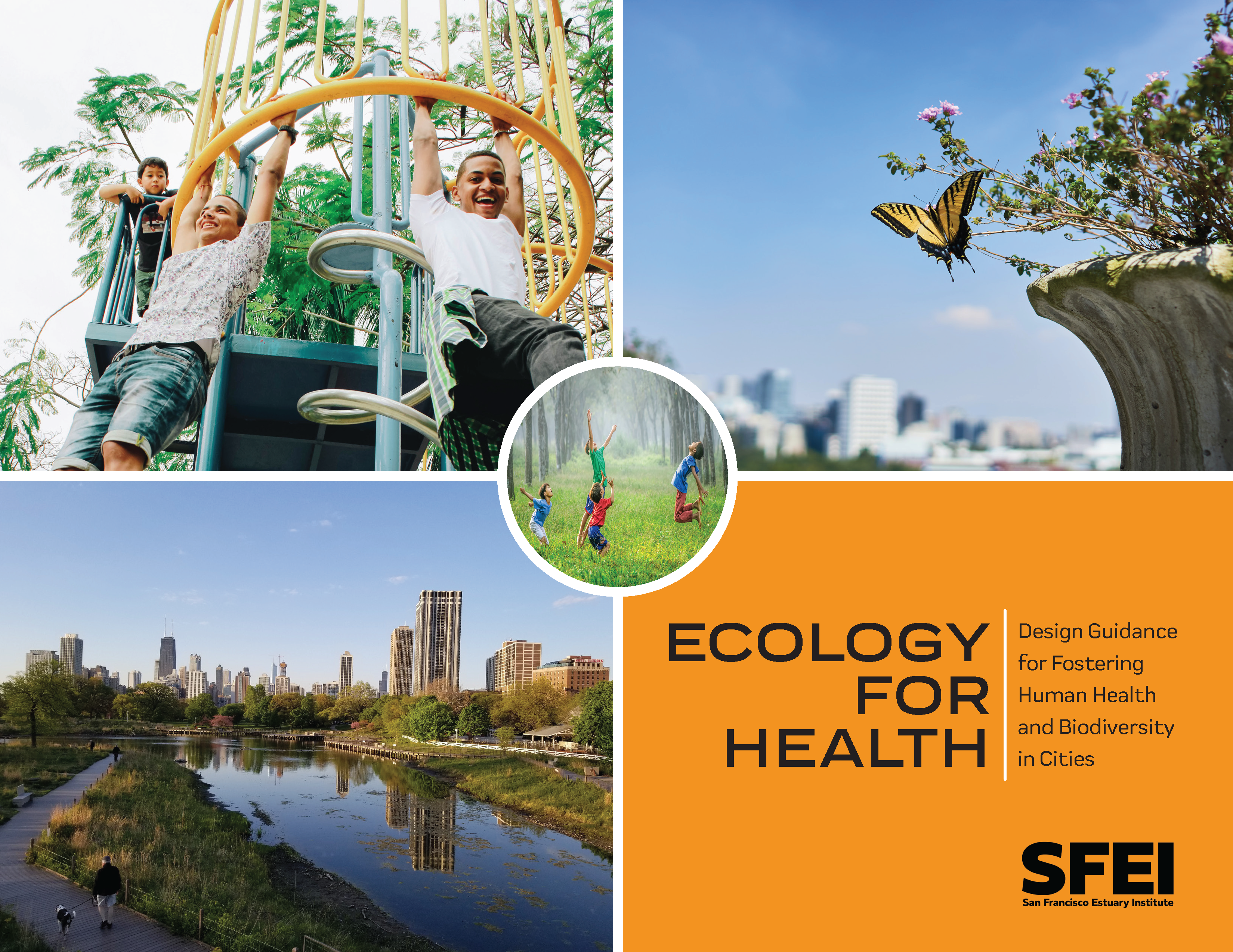 Greenspaces provide crucial nature contact for urban residents. When we have greater access and exposure to nature in the places where we live, work, learn, and play, we tend to experience better human health outcomes. Urban parks, trees, and vegetation encourage physical activity, reduce anxiety and depression, support social cohesion by providing gathering spaces, and are associated with reduced mortality and improved overall health.
While traditionally biodiversity conservation has focused on large open spaces, cities can also play a key role in supporting biodiversity. Many of the world’s major cities developed in biodiversity hotspots due to historical settlement patterns dependent on natural resources. Thus cities contain vital remnant habitat as well as globally important native and endangered species that rely on urban greenspaces.
As urbanization increases, cities around the world are developing and implementing plans to better integrate nature within urban settings. Many of these plans emphasize the importance of urban greening in providing multiple, substantial benefits such as biodiversity conservation, stormwater management, human health and well-being improvements, climate resilience, and more. However not all greenspaces are created equal in their biodiversity support and human health provision.
The goal of this document is to provide science-based guidance for designing urban spaces that foster both human health and urban biodiversity. Anyone making decisions about land use and urban design in cities across the world can benefit from the recommendations in this document (including community organizations, local non-profits, local leaders and policy makers, city planners, urban designers, landscape architects, engineers, gardeners/horticulturists/arborists, residents, and landowners). However, the majority of the document is specifically aimed at supporting designers and planners who work at the planning, site, and detailed design scales such as landscape architects, civil engineers, and urban designers. As noted in more detail in the limitations section below, this document synthesizes global research and design strategies while strongly informed by our experience as scientists and designers in California’s San Francisco Bay Area.
2023. Grain size, bulk density, and carbon content of sediment collected from Whale's Tail South marsh and adjacent bay floor, South San Francisco Bay, California, 2021-2022. U.S. Geological Survey.
Sediment samples were collected on and adjacent to the Whale’s Tail South marsh. Short push-cores of bed sediment were collected in South San Francisco Bay adjacent to Whales Tail South marsh on five days from June through August 2021 and 3 days from November 2021 to January 2022. Additional samples were taken from ceramic tiles placed on the marsh to measure sediment deposition and from rip-up clasts deposited on the marsh edge. Samples were analyzed for sediment properties including bulk density, particle size distribution, and percent carbon. These data were collected as part of a collaborative study with the USGS Western Ecological Research Center to quantify sediment fluxes, deposition on the marsh, and changes in marsh morphology at Whale's Tail marsh in southern San Francisco Bay.
2023. Growing Resilience: Recommendations for Dune Management at North Ocean Beach. SFEI Contribution No. 1155. San Francisco Estuary Institute: Richmond, CA.
2023. Hydrodynamic and sediment transport data from Whale's Tail marsh and adjacent waters in South San Francisco Bay, California 2021-2022. United States Geological Survey.
The U.S. Geological Survey Pacific Coastal and Marine Science Center collected hydrodynamic and sediment-transport data at shallow water sites in South San Francisco Bay and in the Whale's Tail South marsh in Eden Landing Ecological Reserve in Alameda County, CA in 2021 and 2022. This data release includes hydrodynamic and sediment transport time-series data spanning from June 2021 to January 2022, as well as sediment bed properties and water column suspended-sediment concentrations Details on station location, instrumentation, and measured variables are included in sections for each data type. The data were collected to determine sediment supply and sediment delivery to marshes, both in the bay and in tidal creeks as well as across the bay-marsh interface during varying tidal and wave conditions. The goal of the project was to more accurately predict the fate of marshes and to optimize management actions. They were collected as part of a collaborative study with the USGS Western Ecological Research Center. These data are intended for science researchers, students, policy makers, and the general public.
2023. Lahontan Surface Water Ambient Monitoring Program’s 20-Year Water Quality Review and Program Recommendations. SFEI Contribution No. 1110. San Francisco Estuary Institute: Richmond. CA. p 137.
This 20-year water quality monitoring status and trends report for the Lahontan Water Board’s Surface Water Ambient Monitoring Program (Regional SWAMP) provides an overview of the environmental settings across the Region to give the reader a sense of the diverse ecological landscape, land uses, distribution and abundance of aquatic resources, and fire history. It includes a retrospective analysis of the Regional SWAMP’s ongoing, targeted water quality monitoring results (2000 - 2021), and concludes by presenting an adaptive monitoring and assessment framework (adapted from the California Wetlands Monitoring Workgroup's Wetland and Riparian Monitoring Plan, known as "WRAMP"). The framework was used to review the program and recommend future monitoring changes to improve efficiencies and address some of the recommendations listed in the Regional SWAMP's 2019 Core Program Review.
. 2023. Landscape Scenario Planning Tool User Guide v2.2.0. San Francisco Estuary Institute: Richmond, Calif.
2023. Managing Open Space in Support of Net Zero: Carbon sequestration opportunities and tradeoffs in the Alameda Watershed. San Francisco Estuary Institute: Richmond, CA. p 120.
2023. McCosker Creek Restoration and Public Access Project: Alder Creek Daylighting Additional Monitoring Elements - Final Report. SFEI Contribution No. 1157. San Francisco Estuary Institute: Richmond, CA.
2023. Multi-Year Plan 2023. SFEI Contribution No. 1096. San Francisco Estuary Institute: Richmond, California.
The purpose of this document is to guide efforts and summarize plans developed within the RMP. The intended audience includes representatives of the many organizations who directly participate in the Program. This document will also be useful for individuals who are not directly involved with the RMP but are interested in an overview of the Program and where it is heading.
The organization of this Multi-Year Plan parallels the RMP planning process (Figure 2). Section 1 presents the long-term management plans of the agencies responsible for managing water quality in the Bay and the overarching management questions that guide the Program. The agencies’ long-term management plans provide the foundation for RMP planning (Figure 2). In order to turn the plans into effective actions, the RMP distills prioritized lists of management questions that need to be answered (Page 8). The prioritized management questions then serve as a roadmap for scientists on the Technical Review Committee, workgroups, and strategy teams to plan and implement scientific studies to address the most urgent information needs. This information sharpens the focus on management actions that will most effectively and efficiently improve water quality in the Bay.
2023. North Bay Selenium 2019-20 QA Summaries. San Francisco Estuary Institute: Richmond, CA.
2023. Optimizing Chemicals Management in the United States and Canada through the Essential-Use Approach. Environmental Science & Technology 57 (4).
Chemicals have improved the functionality and convenience of industrial and consumer products, but sometimes at the expense of human or ecological health. Existing regulatory systems have proven to be inadequate for assessing and managing the tens of thousands of chemicals in commerce. A different approach is urgently needed to minimize ongoing production, use, and exposures to hazardous chemicals. The premise of the essential-use approach is that chemicals of concern should be used only in cases in which their function in specific products is necessary for health, safety, or the functioning of society and when feasible alternatives are unavailable. To optimize the essential-use approach for broader implementation in the United States and Canada, we recommend that governments and businesses (1) identify chemicals of concern for essentiality assessments based on a broad range of hazard traits, going beyond toxicity; (2) expedite decision-making by avoiding unnecessary assessments and strategically asking up to three questions to determine whether the use of the chemical in the product is essential; (3) apply the essential-use approach as early as possible in the process of developing and assessing chemicals; and (4) engage diverse experts in identifying chemical uses and functions, assessing alternatives, and making essentiality determinations and share such information broadly. If optimized and expanded into regulatory systems in the United States and Canada, other policymaking bodies, and businesses, the essential-use approach can improve chemicals management and shift the market toward safer chemistries that benefit human and ecological health.
. 2023. Petaluma River Baylands Strategy. Prepared by San Francisco Estuary Institute, Sonoma Land Trust, Point Blue Conservation Science, Ducks Unlimited, and Sonoma Resource Conservation District. Funded by the Wildlife Conservation Board.
2023. Pharmaceuticals, pesticides, and ultraviolet filters in wastewater discharges to San Francisco Bay as drivers of ecotoxicity. Environmental Pollution 336 . SFEI Contribution No. 1153.
Research in the United States evaluating ecotoxic risk to receiving waters posed by contaminants occurring in wastewater discharges typically has focused on measurements of pharmaceuticals and personal care products (PPCPs), with limited evaluations of UV filters and phenylpyrazole and neonicotinoid pesticides. In this study, concentrations of 5 representative pharmaceuticals, 11 pesticides or pesticide degradation products, and 5 ultraviolet filters were measured in 24 h composite samples of six wastewater discharges representing ∼70% of the total wastewater discharged to San Francisco Bay during the summer and fall of 2021. No significant difference was observed between concentrations measured on weekdays vs. weekends. A hydrodynamic model of San Francisco Bay was used to estimate annual average dilution factors associated with different subembayments. With and without considering dilution effects, Risk Quotients were calculated using the 90th percentile of measured concentrations in wastewater effluents and threshold concentrations associated with ecotoxicity. Risk Quotients were highest for the neonicotinoid pesticide, imidacloprid, and exceeded ecotoxicity thresholds in the lower South Bay by a factor of 2.4, even when considering dilution. Compared to commonly measured pharmaceuticals, Risk Quotients for imidacloprid were higher than those for carbamazepine, trimethoprim and diclofenac, and comparable to those for propranolol and metoprolol. Risk Quotients for the pesticide, fipronil, and the UV filter, oxybenzone, were higher than for carbamazepine. The results highlight the need to incorporate pesticides and UV filters with high Risk Quotients into studies in the United States evaluating ecotoxic risk associated with contaminants in municipal wastewater discharges.
2023. Quaternary Ammonium Compounds: A Chemical Class of Emerging Concern. Environmental Science & Technology 57 (20), 7645-7665.
Quaternary ammonium compounds (QACs), a large class of chemicals that includes high production volume substances, have been used for decades as antimicrobials, preservatives, and antistatic agents and for other functions in cleaning, disinfecting, personal care products, and durable consumer goods. QAC use has accelerated in response to the COVID-19 pandemic and the banning of 19 antimicrobials from several personal care products by the US Food and Drug Administration in 2016. Studies conducted before and after the onset of the pandemic indicate increased human exposure to QACs. Environmental releases of these chemicals have also increased. Emerging information on adverse environmental and human health impacts of QACs is motivating a reconsideration of the risks and benefits across the life cycle of their production, use, and disposal. This work presents a critical review of the literature and scientific perspective developed by a multidisciplinary, multi-institutional team of authors from academia, governmental, and nonprofit organizations. The review evaluates currently available information on the ecological and human health profile of QACs and identifies multiple areas of potential concern. Adverse ecological effects include acute and chronic toxicity to susceptible aquatic organisms, with concentrations of some QACs approaching levels of concern. Suspected or known adverse health outcomes include dermal and respiratory effects, developmental and reproductive toxicity, disruption of metabolic function such as lipid homeostasis, and impairment of mitochondrial function. QACs’ role in antimicrobial resistance has also been demonstrated. In the US regulatory system, how a QAC is managed depends on how it is used, for example in pesticides or personal care products. This can result in the same QACs receiving different degrees of scrutiny depending on the use and the agency regulating it. Further, the US Environmental Protection Agency’s current method of grouping QACs based on structure, first proposed in 1988, is insufficient to address the wide range of QAC chemistries, potential toxicities, and exposure scenarios. Consequently, exposures to common mixtures of QACs and from multiple sources remain largely unassessed. Some restrictions on the use of QACs have been implemented in the US and elsewhere, primarily focused on personal care products. Assessing the risks posed by QACs is hampered by their vast structural diversity and a lack of quantitative data on exposure and toxicity for the majority of these compounds. This review identifies important data gaps and provides research and policy recommendations for preserving the utility of QAC chemistries while also seeking to limit adverse environmental and human health effects.
2023. Reconnecting Riverside with its River: Integrating Historical and Urban Ecology for a Healthier Future. SFEI Contribution No. 1133. San Francisco Estuary Institute: Richmond, Ca.
2023. Re-evaluation of the Floating Percentile Method for Deriving Dredged Sediment Screening Guidelines. SFEI Contribution No. 1143. San Francisco Estuary Institute: Richmond, California.
This document summarizes a study conducted for the Regional Monitoring Program for Water Quality in San Francisco Bay (RMP) to re-evaluate the use of the Floating Percentile Method
(FPM) to derive sediment screening guidelines for dredged material reuse in the San Francisco Bay Region. The Long Term Management Strategy (LTMS) has a goal to use at least 40% of the sediment dredged from San Francisco Bay for beneficial reuse (USACE, 1998). The suitability of dredged sediment for beneficial reuse is in part determined by concentrations of toxic pollutants.The San Francisco Regional Water Quality Control Board (SFB-RWQCB) issued draft screening criteria in 2000 to categorize the suitability of sediment for reuse as either “surface” sediment, that may be placed near the surface for re-use in wetlands, or “foundation” sediment, that is buried under sediment that meets surface criteria. Contaminant concentration guidelines for surface sediment are lower than foundation sediment, based on the assumption that biota are more likely to be exposed to surface sediment than deeper foundation sediment.
2023. Regional Analysis of Potential Beneficial Use Locations. Conducted for the San Francisco Bay Regional Dredged Material Management Plan. Prepared by the San Francisco Estuary Institute for the US Army Corps of Engineers, San Francisco District. SFEI Contribution No. 1178. San Francisco Estuary Institute: Richmond, CA.
2023. Restoration Plan for the Laguna de Santa Rosa. SFEI Contribution No. 1123. San Francisco Estuary Institute: Richmond, CA.
The Laguna de Santa Rosa is an expansive freshwater wetland complex that hosts a rich diversity of plant and wildlife species, and is also home to a thriving agricultural community. Since the mid-19th century, modifications to the Laguna and its surrounding landscape have degraded habitat conditions for both wildlife and people. Together with partners at the Laguna de Santa Rosa Foundation, and funded by Sonoma Water and the California Department of Fish and Wildlife, the goal of the Laguna de Santa Rosa Master Restoration Plan project is to develop a plan that supports ecosystem services in the Laguna—through the restoration and enhancement of landscape processes that form and sustain habitats and improve water quality—while considering flood management issues and the productivity of agricultural lands.
The first phase of the project was the creation of the Restoration Vision for the Laguna de Santa Rosa. The report details a long-term vision for the landscape which highlights opportunities for multi-benefit habitat restoration and land management within the Laguna’s 100-year floodplain. It presents an understanding of the landscape functioning from past, present, and potential future perspectives. Starting with a picture of the historical ecology of the Laguna that details the magnitude of change in habitat conditions over the past two centuries, the document then presents an understanding of key physical processes that affect today’s Laguna. The restoration concepts described in the Vision represent a potential future Laguna, and were developed and vetted through a series of workshops in which technical advisers, management advisers, tribal representatives, and local landowners and stakeholders shared their expertise and helped shape the concepts.
The second phase of this project was the development of a Restoration Plan for the Laguna de Santa Rosa that was built from the Vision. The Restoration Plan was developed through a collaborative process that focused on moving forward identified restoration opportunities into conceptual designs that can be used to establish implementable restoration projects. The Restoration Plan includes the following elements:
- A restoration framework that offers a planning structure for landscape scale restoration that can be further developed and refined over time.
- Restoration project concepts in the Laguna’s 100-year floodplain developed from selected restoration opportunity areas shown in the Vision.
- Criteria for prioritizing and sequencing restoration project concepts.
The utilization of the Restoration Plan and the ultimate success of restoration efforts in the Laguna will require local landowner support and adequate funding to implement the restoration and manage and sustain the benefits through long-term stewardship. It will also require coordination among all the agencies responsible for managing the land and water within the Laguna and its surrounding watershed. With commitment and collaboration the Laguna
2023. San Francisco Bay Sediment Modeling and Monitoring Workplan. SFEI Contribution No. 1100. San Francisco Estuary Institute: Richmond, CA.
This document was prepared with guidance gained through two RMP Sediment Workgroup workshops held in late 2022 and early 2023. Given the variety of participants involved, this Workplan encompasses interests beyond San Francisco Bay RMP funders. We thank the attendees for their contributions.
In 2020, the Sediment Workgroup (SedWG) of the Regional Monitoring Program for Water Quality in San Francisco Bay (RMP) completed a Sediment Monitoring and Modeling Strategy (SMMS) which laid out a conceptual level series of data and information gaps and generally recommended the use of both empirical data collection and modeling tools to answer initial high priority management questions (McKee et al., 2020). At the time, the SMMS promoted the use of surrogates such as time-continuous turbidity measurements for cross-section flux modeling within the Bay without an understanding of existing Bay hydrodynamic models, their strengths, weaknesses, and potential uses for understanding coupled Bay-mudflat-marsh processes. Since then, the Wetland Regional Monitoring Program (WRMP, www.wrmp.org) has generally promoted the use of coupling monitoring and modeling techniques to inform wetlands sediment management decisions. In addition, he completion of the Sediment for Survival report (a RMPEPA funded collaboration) and the further development of sediment conceptual models has also advanced the need for a coupled dynamic modeling and monitoring program that has the capacity to explore more complex management questions (Dusterhoff et al., 2021; SFEI, 2023). Such a program will take time to develop, but will be more cost-efficient and adaptable and allow for more timely answers to pressing questions.
2023. Sediment Deposition and Accretion Data from a Tidal Salt Marsh in South San Francisco Bay, California 2021-2022. U.S. Geological Survey Western Ecological Research Center .
The U.S. Geological Survey, Western Ecological Research Center collected sediment and accretion data at a wave-exposed tidal salt marsh in South San Francisco Bay, California. Sediment traps and feldspar marker horizons (MH) were deployed along transects of increasing distance from the sediment source, at primary, secondary and tertiary marsh channels/bay. Data were collected bi-monthly over two month periods in summer 2021 and winter 2021/2022. Included here are trap and MH plot locations, calculated sediment fluxes at each station by deployment period, annual accretion rates, and covariates associated with sediment deposition and accretion including vegetation structure and elevation. This project aimed to assess the temporal and spatial patterns in sediment deposition in order to better understand sediment delivery and marsh resilience to sea-level rise.
2023. Sediment deposition, erosion, and bathymetric change in San Francisco Bay, California, 1971–1990 and 1999–2020. United States Geological Survey Pacific Coastal and Marine Science Center: Santa Cruz, CA.
Bathymetric change analyses document historical patterns of sediment deposition and erosion, providing valuable insight into the sediment dynamics of coastal systems, including pathways of sediment and sediment-bound contaminants. In 2014 and 2015, the Office for Coastal Management, in partnership with the National Oceanic and Atmospheric Administration (NOAA) Office of Coastal Management, provided funding for new bathymetric surveys of large portions of San Francisco Bay. A total of 93 bathymetric surveys were conducted during this 2-year period, using a combination of interferometric sidescan and multibeam sonar systems. These data, along with recent NOAA, U.S. Geological Survey (USGS), U.S. Army Corps of Engineers, and private contractor surveys collected from 1999 to 2020 (hereinafter referred to as 2010s), were used to create the most comprehensive bathymetric digital elevation models (DEMs) of San Francisco Bay since the 1980s. Comparing DEMs created from these 2010s surveys with USGS DEMs created from NOAA’s 1971–1990 (hereinafter referred to as 1980s) surveys provides information on the quantities and patterns of erosion and deposition in San Francisco Bay during the 9 to 47 years between surveys. This analysis reveals that in the areas surveyed in both the 1980s and 2010s, the bay floor lost about 34 million cubic meters of sediment since the 1980s. Results from this study can be used to assess how San Francisco Bay has responded to changes in the system, such as sea-level rise and variation in sediment supply from the Sacramento-San Joaquin Delta and local tributaries, and supports the creation of a new, system-wide sediment budget. This report provides data on the quantities and patterns of sediment volume change in San Francisco Bay for ecosystem managers that are pertinent to various sediment-related issues, including restoration of tidal marshes, exposure of legacy contaminated sediment, and strategies for the beneficial use of dredged sediment.
2023. Sediment Deposition, Erosion, and Bathymetric Change in San Francisco Bay, California, 1971–1990 and 1999–2020. United State Geological Survey: Santa Cruz, CA.
Bathymetric change analyses document historical patterns of sediment deposition and erosion, providing valuable insight into the sediment dynamics of coastal systems, including pathways of sediment and sediment-bound contaminants. In 2014 and 2015, the California Ocean Protection Council, in partnership with the National Oceanic and Atmospheric Administration (NOAA) Office of Coastal Management, provided funding for new bathymetric surveys of large portions of San Francisco Bay. A total of 93 bathymetric surveys were conducted during this 2-year period, using a combination of interferometric sidescan and multibeam sonar systems. These data, along with recent NOAA, U.S. Geological Survey (USGS), U.S. Army Corps of Engineers, and private contractor surveys collected from 1999 to 2020 (hereinafter referred to as 2010s), were used to create the most comprehensive bathymetric digital elevation models (DEMs) of San Francisco Bay since the 1980s. Comparing DEMs created from these 2010s surveys with USGS DEMs created from NOAA’s 1971–1990 (hereinafter referred to as 1980s) surveys provides information on the quantities and patterns of erosion and deposition in San Francisco Bay during the 9 to 47 years between surveys. This analysis reveals that in the areas surveyed in both the 1980s and 2010s, the bay floor lost about 34 million cubic meters of sediment since the 1980s. Results from this study can be used to assess how San Francisco Bay has responded to changes in the system, such as sea-level rise and variation in sediment supply from the Sacramento-San Joaquin Delta and local tributaries, and supports the creation of a new, system-wide sediment budget. This report provides data on the quantities and patterns of sediment volume change in San Francisco Bay for ecosystem managers that are pertinent to various sediment-related issues, including restoration of tidal marshes, exposure of legacy contaminated sediment, and strategies for the beneficial use of dredged sediment.
2023. Stevens Creek Reservoir – Forecast Informed Reservoir Operation (FIRO) Phase One Report. . SFEI Contribution No. 1120. Prepared for SCV Water District.
2023. Structure-from-motion derived orthomosaic imagery and digital surface models (DSMs) from the intertidal region at Whale's Tail Marsh, South San Francisco Bay, CA. United States Geological Survey: South San Francisco Bay, CA.
This data release presents digital surface models (DSMs) and orthomosaic images of the Whale's Tail Marsh region of South San Francisco Bay, CA. The data were created using structure-from-motion (SfM) processing of repeat aerial imagery collected from fixed-wing aircraft. The raw images were acquired from an approximate altitude of 427 meters (1,400 feet) above ground level (AGL), using a Hasselblad A6D-100c camera fitted with an HC 80 lens, resulting in a nominal ground-sample-distance (GSD) of 2.5 centimeters per pixel. The acquisition flight lines were designed to provide approximately 50 percent overlap between adjacent flight lines (sidelap), with approximately 70 percent overlap between sequential images along the flight line (forelap). Survey control was established using an onboard camera-synchronized dual-frequency GPS system as well as ground control points (GCPs) distributed throughout the survey area and measured using survey-grade post-processed kinematic (PPK) GPS. Both the data from the onboard GPS and from the GPS used to measure the GCPs were post-processed using a nearby Continuously Operating Reference Station (CORS) operated by the National Geodetic Survey (NGS). Structure-from-motion processing of these data was conducted using a "4D" processing workflow in which imagery from each of the different acquisition dates were co-aligned to increase relative spatial precision between the final data products.
2023. Suspended Sediment Loads Analysis of Four Creeks in the San Francisco Bay Area. SFEI Contribution No. 1134. San Francisco Estuary Institute: Richmond, CA.
. 2023. Sycamore Alluvial Woodland Pilot Study Implementation Guidelines. Prepared for Zone 7 Water Agency and US Environmental Protection Agency’s Water Quality Improvement Fund. In collaboration with San Francisco Estuary Institute.
This document supports planting-based approaches for sycamore enhancement by providing site-level revegetation techniques for installing, maintaining and monitoring sycamore plantings.
2023. Sycamore Alluvial Woodland Restoration and Enhancement Suitability Study. In collaboration with Alameda County Flood Control and Water Conservation District, Zone 7. Prepared for the US Environmental Protection Agency’s Water Quality Improvement Fund. SFEI Contribution No. 1128. San Francisco Estuary Institute: Richmond, CA.
 The “Sycamore Alluvial Woodland Restoration and Enhancement Suitability Study” addresses distribution and regeneration patterns and restoration strategies of sycamore alluvial woodland (SAW) habitat, a unique and relatively rare native vegetation community adapted to California’s intermittent rivers and streams. The report was produced by SFEI and H. T. Harvey & Associates, as part of the US EPA Water Quality Improvement Fund Preparing for the Storm grant, led by Zone 7 Water Agency.
2023. Tire Wear: Emissions Estimates and Market Insights to Inform Monitoring Design. SFEI Contribution No. 1109. San Francisco Estuary Institute: Richmond, CA.
Every vehicle on the road sheds tiny particles from its rubber tires into the environment. Tire wear is one of the top sources of microplastic releases to the environment. Tire wear also disperses tire-related chemicals into the environment. SFEI studies supported by the Regional Monitoring Program for Water Quality in San Francisco Bay (RMP) and others have found tire wear particles and tire-related chemicals in San Francisco Bay and its small tributaries, which drain the Bay watershed’s local urban areas. The RMP has developed a short-term multi-year plan of potential special studies (“Tires Strategy”) that responds to recent data revealing the magnitude of tire particle and chemical emissions and their potential toxicity to aquatic organisms.
This article is available upon request. Please message [email protected] for the materials.
2023. Translating Sediment Science Into Action: Documenting Beneficial Sediment Reuse. SFEI Contribution No. 1124. San Francisco Estuary Institute: Richmond, CA.
 The Preparing for the Storm project, led by Zone 7 Water Agency (Zone 7) and funded by the US Environmental Protection Agency (EPA) Water Quality Improvement Fund, aims to develop science-based plans, strengthen existing and new partnerships, and pilot new methodologies for tackling these issues surrounding coarse sediment. As a task within this larger project, this report describes four projects in the East Bay that serve as case studies for beneficial reuse of sediment. Each example highlights a project with sediment that could be reused (in lieu of landfilling) or a project that needs additional sediment and could benefit from deliveries of sediment that normally would not have been beneficially reused.
2023. Triclosan and Methyl Triclosan in Prey Fish in a Wastewater-influenced Estuary. Environmental Toxicology and Chemistry 42 (3), 620-627 . SFEI Contribution No. 1112.
While the antimicrobial ingredient triclosan has been widely monitored in the environment, much less is known about the occurrence and toxicity of its major transformation product, methyl triclosan. An improved method was developed and validated to effectively extract and quantify both contaminants in fish tissue and was used to characterize concentrations in small prey fish in areas of San Francisco Bay where exposure to triclosan via municipal wastewater discharges was expected to be highest. Concentrations of triclosan (0.44–57 ng/g ww, median 1.9 ng/g ww) and methyl triclosan (1.1–200 ng/g ww, median 36 ng/g ww) in fish tissue decreased linearly with concentrations of nitrate in site water, used as indicators of wastewater influence. The total concentrations of triclosan and methyl triclosan measured in prey fish were below available toxicity thresholds for triclosan, but there are few ecotoxicological studies to evaluate impacts of methyl triclosan. Methyl triclosan represented up to 96% of the total concentrations observed. These results emphasize the importance of monitoring contaminant transformation products, which can be present at higher levels than the parent compound.
2023. Water Year 2023 RMP Near-Field Water Sampling and Analysis Plan. SFEI Contribution No. 1142. San Francisco Estuary Institute: Richmond, CA.
This report details plans associated with the pilot near-field water sampling for the Regional Monitoring Program for Water Quality in San Francisco Bay (RMP). The RMP recently reviewed the Status & Trends (S&T) Program and added a pilot effort to quantify contaminants of emerging concern (CECs) in Bay water in areas near (“near-field” of) expected loading pathways during or shortly after storm events and during the dry season. For the first year of the pilot (Water Year 2022), the near-field design included three targeted, near-field stations and four ambient Bay stations. Subsequent years added a fourth near-field station. Samples will be collected at these stations during or shortly after two storm events, and once in the dry season. The analytes that are being measured include bisphenols, organophosphate esters (OPEs), PFAS, and a suite of stormwater CECs.
. 2023. Where creeks meet baylands: Opportunities to re-establish freshwater and sediment delivery to the baylands of San Francisco Bay. SFEI Contribution No. 1150. San Francisco Estuary Institute: Richmond, CA.
2023. WRAMP Training and Outreach Plan. SFEI Contribution No. 1136. p 39.
 The goal of this Training and Outreach Plan is to increase the overall awareness and use of the WRAMP datasets and tools in support of wetland resource planning, management, and project performance tracking in California. Specifically, a near-term goal is to develop modular training sessions that can be linked together in different ways to customize how the datasets, monitoring methods, and online tools might be used for different purposes.
. 2022. 2021 RMP Water Cruise Report. SFEI Contribution No. 1098. Applied Marine Sciences: Livermore, CA.
This report details activities associated with the biannual Regional Monitoring Program for Water Quality in the San Francisco Estuary (RMP) water cruise. The RMP water sampling program was redesigned in 2002 to adopt a randomized sampling design at thirty-one sites in place of the twenty-six “spine of the Estuary” stations sampled previously. In 2007, the number of sites was decreased to twenty-two stations, combined probabilistic and historic, and it remains as such for 2021.
2022. 2022 Pulse of the Bay. SFEI Contribution No. 1095. San Francisco Estuary Institute: Richmond, California.
 The theme of the 2022 Pulse is "50 Years After the Clean Water Act." Nine different individuals or groups have contributed perspectives on progress to date and challenges ahead. This Pulse also includes summaries, from a historical perspective, on the major water quality parameters of concern in the Bay.
2022. 2022 Pulse Resources.
2022. 2022 RMP Multi-Year Plan. SFEI Contribution No. 1058. San Francisco Estuary Institute: Richmond, California.
2022. 2023 Detailed Workplan and Budget. SFEI Contribution No. 1117. San Francisco Estuary Institute: Richmond, California.
2022. Adaptation Pathways: San Leandro Operational Landscape Unit. SFEI Contribution No. 1077. San Francisco Estuary Institute: Richmond, CA.
2022. Adaptation Planning for the Bay Point Operational Landscape Unit. SFEI Contribution No. 1078. San Francisco Estuary Institute: Richmond, CA.
2022. An assessment of future tidal marsh resilience in the San Francisco Estuary through modeling and quantifiable metrics of sustainability. Frontiers in Environmental Science 10.
Quantitative, broadly applicable metrics of resilience are needed to effectively manage tidal marshes into the future. Here we quantified three metrics of temporal marsh resilience: time to marsh drowning, time to marsh tipping point, and the probability of a regime shift, defined as the conditional probability of a transition to an alternative super-optimal, suboptimal, or drowned state. We used organic matter content (loss on ignition, LOI) and peat age combined with the Coastal Wetland Equilibrium Model (CWEM) to track wetland development and resilience under different sea-level rise scenarios in the Sacramento-San Joaquin Delta (Delta) of California. A 100-year hindcast of the model showed excellent agreement (R2 = 0.96) between observed (2.86 mm/year) and predicted vertical accretion rates (2.98 mm/year) and correctly predicted a recovery in LOI (R2 = 0.76) after the California Gold Rush. Vertical accretion in the tidal freshwater marshes of the Delta is dominated by organic production. The large elevation range of the vegetation combined with high relative marsh elevation provides Delta marshes with resilience and elevation capital sufficiently great to tolerate centenary sea-level rise (CLSR) as high as 200 cm. The initial relative elevation of a marsh was a strong determinant of marsh survival time and tipping point. For a Delta marsh of average elevation, the tipping point at which vertical accretion no longer keeps up with the rate of sea-level rise is 50 years or more. Simulated, triennial additions of 6 mm of sediment via episodic atmospheric rivers increased the proportion of marshes surviving from 51% to 72% and decreased the proportion drowning from 49% to 28%. Our temporal metrics provide critical time frames for adaptively managing marshes, restoring marshes with the best chance of survival, and seizing opportunities for establishing migration corridors, which are all essential for safeguarding future habitats for sensitive species.
2022. Bisphenols in San Francisco Bay: Wastewater, Stormwater, and Margin Sediment Monitoring. SFEI Contribution No. 1093. San Francisco Estuary Institute: Richmond, CA.
Bisphenols are a class of synthetic, mobile, endocrine-disrupting chemicals. Bisphenol A (BPA), the most well-studied bisphenol, is produced and used in vast quantities worldwide—especially in polycarbonate plastics and as a polymer additive. Recently, some manufacturers have begun using alternative bisphenol compounds, such as bisphenol F (BPF) and bisphenol S (BPS). These uses of bisphenols have led to widespread bisphenol detections in the environment and wildlife. The present study examined wastewater effluent in the San Francisco Bay Area and San Francisco Bay sediment samples for 17 bisphenols. The effluent samples were compared to available stormwater runoff data to better understand bisphenol transport, fate, and potential risks to wildlife.
2022. Building Capacity of the California Wetland Program Plan to Protect and Restore Vernal Pools. SFEI Contribution No. 1087. San Francisco Estuary Institute: Richmond. CA. p 30.
This report describes the updates to the vernal pool habitat map, the development of the ambient baseline ecological condition survey of vernal pool systems within the Central Valley, and the development and results of the habitat development curve. A fictional project example shows how CRAM and the vernal pool complex CDFs and HDCs can help project proponents and the regulatory agencies think critically about project designs (using CRAM Attributes and Metrics as a standard measure), evaluate project conditions within a regional landscape context, and monitor project performance over time to ensure that project goals are met.
Funding for this report was provided through an agreement with the U.S. Environmental Protection Agency (USEPA). This report does not necessarily reflect the views and policies of USEPA nor does the mention of trade names or commercial products within this report constitute endorsement or recommendation for use.
2022. CECs in California’s Ambient Aquatic Ecosystems: Occurrence and Risk Screening of Key Classes. SFEI Contribution No. 1066. Aquatic Science Center: Richmond, CA.
2022. Charter: Regional Monitoring Program for Water Quality in San Francisco Bay. SFEI Contribution No. 1184. San Francisco Estuary Institute: Richmond, CA.
This Charter describes the purpose and function of the Regional Monitoring Program for Water
Quality in San Francisco Bay (RMP). Established in 1993, the RMP is a collaborative effort
between the San Francisco Estuary Institute, the California Regional Water Quality Control
Board, San Francisco Bay Region, and the regulated discharger community.
2022. Delta Wetland Futures: Blue Carbon and Elevation Change. SFEI Contribution No. 1105. San Francisco Estuary Institute: Richmond, CA.
2022. Delta Wetland Futures: Tidal Marsh Resilience to Sea Level Rise. SFEI Contribution No. 1106. San Francisco Estuary Institute: Richmond, CA.
2022. Ecological Horticulture at the Presidio. . SFEI Contribution No. 1080. San Francisco Estuary Institute: Richmond, Ca.
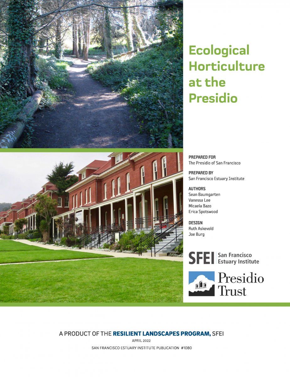 The Presidio of San Francisco—the nation’s largest urban national park—is located in an area of exceptional ecological diversity. Historically, many different habitat types thrived in the mix of windswept dunes, riparian forests, and curious dwarf oak woodlands that characterized this landscape. Many of these habitat types are rare today (and some were even rare in the region historically), and together they harbor a host of unique plants and animals.
2022. ELEVATION AND OPPORTUNITY IN THE DELTA: Restoring the right thing in the right place. SFEI Contribution No. 1082. San Francisco Estuary Institute: Richmond, Ca.

A future Sacramento-San Joaquin Delta and Suisun Marsh (“Delta” herein) that supports healthy ecosystems and native species, while also meeting flood risk reduction, water supply, water quality, carbon sequestration, economic, and cultural objectives, requires that appropriate restoration and management actions be taken in the right place at the right time. Geographic setting affects the potential opportunities available—not all actions are suitable everywhere. Physical factors determining what types of activities are appropriate now and in the future include a site’s elevation, degree of tidal and fluvial influence, salinity, soil type, and local effects of climate change, which all vary spatially across the Delta. While there has been considerable progress over the last several decades, continued acceleration of the pace and scale of enhancement actions appropriate to landscape position is needed. Understanding the physical template is necessary for developing strategies that move beyond opportunistic restoration, support resilience over time, and have the potential to connect and magnify benefits across the larger landscape.
2022. Leveraging Wetlands for a Better Climate Future: Incorporating Blue Carbon into California's Climate Planning. SFEI Contribution No. 1084. San Francisco Estuary Institute: Richmond, CA. p 31.
 The 2022 update to California’s climate change Scoping Plan incorporates management actions in the state’s forests, shrublands/chaparral, grasslands, croplands, developed lands, deltaic wetlands, and sparsely vegetated lands. Missing from this list are the tidally-influenced coastal ecosystems outside the Sacramento-San Joaquin Delta. These blue carbon ecosystems support high rates of carbon storage and sequestration while providing many co-benefits that can enhance coastal climate change resilience. With sufficient data and robust modeling approaches, California has the opportunity to incorporate blue carbon in future Scoping Plan updates and set actionable targets for restoration, migration space conservation, and other management activities that promote long-term survival of the state’s coastal wetlands. To support this goal, this report offers a high-level overview of the state of the science for blue carbon quantification in California. This summary, which covers datasets and quantification approaches, key focus areas for additional science investment, and example scenarios for coastal wetland restoration, is intended to facilitate broader inclusion of blue carbon in future Scoping Plan updates and other state-level climate-planning documents.
2022. A living tool for the continued exploration of microplastic toxicity. Microplastics and Nanoplastics 2 (13).
Throughout the past decade, many studies have reported adverse effects in biota following microplastic exposure. Yet, the field is still emerging as the current understanding of microplastic toxicity is limited. At the same time, recent legislative mandates have required environmental regulators to devise strategies to mitigate microplastic pollution and develop health-based thresholds for the protection of human and ecosystem health. The current publication rate also presents a unique challenge as scientists, environmental managers, and other communities may find it difficult to keep up with microplastic research as it rapidly evolves. At present, there is no tool that compiles and synthesizes the data from these studies to allow for visualization, interpretation, or analysis. Here, we present the Toxicity of Microplastics Explorer (ToMEx), an open access database and open source accompanying R Shiny web application that enables users to upload, search, visualize, and analyze microplastic toxicity data. Though ToMEx was originally created to facilitate the development of health-based thresholds to support California legislations, maintaining the database by the greater scientific community will be invaluable to furthering research and informing policies globally. The database and web applications may be accessed at https://microplastics.sccwrp.org/.
2022. Microplastics from Tire Particles in San Francisco Bay Factsheet. SFEI Contribution No. 1074. San Francisco Estuary Institute: Richmond, CA.
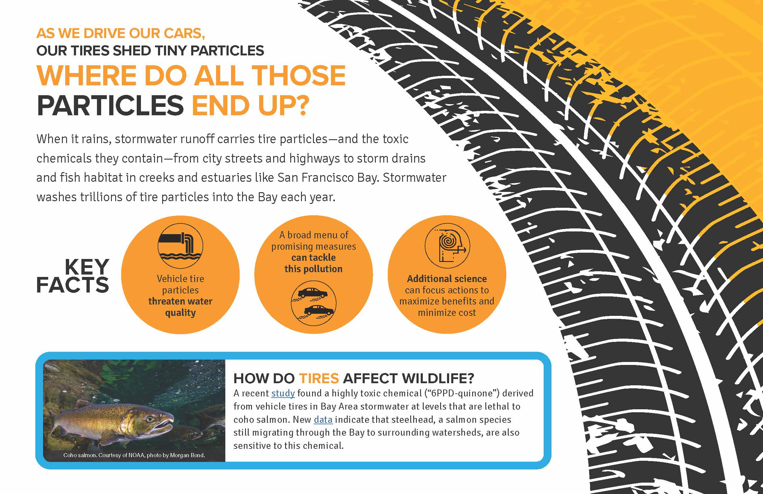 As we drive our cars, our tires shed tiny particles
When it rains, stormwater runoff carries tire particles—and the toxic chemicals they contain—from city streets and highways to storm drains and fish habitat in creeks and estuaries like San Francisco Bay. Stormwater washes trillions of tire particles into the Bay each year.
How do tires affect wildlife?
A recent study found a highly toxic chemical (“6PPD-quinone”) derived from vehicle tires in Bay Area stormwater at levels that are lethal to coho salmon. New data indicate that steelhead, a salmon species still migrating through the Bay to surrounding watersheds, are also sensitive to this chemical.
2022. Occurrence and risk assessment of organophosphate esters and bisphenols in San Francisco Bay, California, USA. Science of the Total Environment 813 . SFEI Contribution No. 982.
Organophosphate esters (OPEs) and bisphenols are two classes of industrial chemicals that are ubiquitously detected in environmental matrices due to high global production and widespread use, particularly in the manufacture of plastic products. In 2017, water samples collected throughout the highly urbanized San Francisco Bay were analyzed for 22 OPEs and 16 bisphenols using liquid chromatography-electrospray ionization-Q Trap-mass spectrometry. Fifteen of the 22 OPEs were detected, with highest median concentrations in the order TCPP (42 ng/L) > TPhP (9.5 ng/L) > TBOEP (7.6 ng/L) > TnBP (7.5 ng/L) > TEP (6.7 ng/L) > TDCIPP (6.2 ng/L). In contrast, only two of 16 bisphenols, BPA and BPS, were quantified, with concentrations ranging from <0.7–35 ng/L and <1–120 ng/L, respectively. BPA and a few OPEs (EHDPP and TEHP) were primarily present in the particulate phase, while BPS and all other observed OPEs were predominantly found in the dissolved phase. Pairwise correlation analysis revealed several strong, positive correlations among OPEs, and few weak, negative correlations between OPEs and BPA, suggesting differences between the two classes with respect to their sources, pathways, and/or fate in the environment. Concentrations of OPEs and bisphenols observed in this study were generally consistent with reported concentrations in other estuarine and marine settings globally. TDCIPP exceeded existing predicted no-effect concentrations (PNECs) at some sites, and six other compounds (TCrP, IDDPP, EHDPP, TPhP, TBOEP, and BPA) were observed at levels approaching individual compound PNECs (not considering mixture effects), indicating potential risks to Bay biota. These results emphasize the need to control releases of these contaminants in order to protect the ecosystem. Periodic monitoring can be used to maintain vigilance in the face of potential regrettable substitutions.
2022. PFAS in San Francisco Bay Water. SFEI Contribution No. 1094. San Francisco Estuary Institute: Richmond, CA.
Per- and polyfluoroalkyl substances (PFAS), a family of thousands of synthetic, fluorine-rich compounds commonly referred to as “forever chemicals,” are known for their thermal stability, non-reactivity, and surfactant properties. These unique compounds have widespread uses across consumer, commercial, and industrial products, resulting in widespread occurrence in the environment and wildlife across the globe. This study analyzed ambient surface water in San Francisco Bay for 40 PFAS to discern the occurrence, fate, and potential risks to ecological and human health.
Eleven of 40 PFAS were detected in ambient surface water collected in 2021 from 22 sites in the Bay. Seven PFAS (PFPeA, PFHxA, PFHpA, PFOA, PFBS, PFHxS, and PFOS), were found in at least 50% of samples. PFHxA and PFOA were the most frequently detected analytes (detection frequencies of 86% and 77%, respectively). PFPeA and PFHxA were generally found at the highest concentrations across sites, with median and maximum concentrations of 1.6 and 4.8 ng/L and 1.5 and 5.7 ng/L, respectively. Pairwise Spearman's correlations revealed strong positive correlations (p <0.001; r > 0.77) among the seven PFAS detected in at least 50% of sites, suggesting significant similarities between their sources, pathways, and/or fate in the environment. PFBA, PFNA, PFDA, and 6:2 FTS were found at a limited number of sites in the Bay. 6:2 FTS was found at a single site at 14 ng/L, the highest concentration of any individual PFAS in the Bay. The sums of detected PFAS for all sites had median and maximum concentrations of 10 and 29 ng/L, respectively.
2022. Priority margin unit stormwater monitoring to support load estimates of PCBs into San Leandro Bay and the Emeryville Crescent. SFEI Contribution No. 1088. San Francisco Estuary Institute: Richmond, CA.
2022. Research recommendations to better understand the potential health impacts of microplastics to humans and aquatic ecosystems. Microplastics and Nanoplastics 2 (18).
To assess the potential risk of microplastic exposure to humans and aquatic ecosystems, reliable toxicity data is needed. This includes a more complete foundational understanding of microplastic toxicity and better characterization of the hazards they may present. To expand this understanding, an international group of experts was convened in 2020–2021 to identify critical thresholds at which microplastics found in drinking and ambient waters present a health risk to humans and aquatic organisms. However, their findings were limited by notable data gaps in the literature. Here, we identify those shortcomings and describe four categories of research recommendations needed to address them: 1) adequate particle characterization and selection for toxicity testing; 2) appropriate experimental study designs that allow for the derivation of dose-response curves; 3) establishment of adverse outcome pathways for microplastics; and 4) a clearer understanding of microplastic exposure, particularly for human health. By addressing these four data gaps, researchers will gain a better understanding of the key drivers of microplastic toxicity and the concentrations at which adverse effects may occur, allowing a better understanding of the potential risk that microplastics exposure might pose to human and aquatic ecosystems.
2022. RESILIENT STATEN ISLAND: Landscape Scenario Analysis Pilot Application. SFEI Contribution No. 1083. San Francisco Estuary Institute: Richmond, Ca.
 A central motivating question for the Sacramento-San Joaquin Delta science and management community is what should be done, where and when, to support future Delta landscapes that are ecologically and economically viable and resilient to change. Actions must be taken that have the greatest potential for achieving multiple benefits. This is especially important given the urgency to rapidly transition Delta landscapes to address biodiversity loss, erosion of ecosystem resilience, flood risk, water supply reliability, and cultural and economic sustainability. Landscape-scale planning is needed to examine how individual actions add up to meaningful change. Such planning involves figuring out how different areas can provide different functions at different times and helps show how choices made now can help shift trajectories toward desired outcomes. Too often, land use and management decisions are made based on a limited set of objectives or at the site scale, resulting in missed opportunities. Actions (or inaction) should not foreclose on critical opportunities. Moving forward, there is great need to more effectively compare possible future scenarios across a range of ecological and economic factors. This scenario analysis for Staten Island — a large Delta island managed for multiple uses and facing challenges similar to elsewhere in the Delta — provides an approach to help address this need.
2022. Risk-based management framework for microplastics in aquatic ecosystems. Microplastics and Nanoplastics 2 (17).
Microplastic particles (MPs) are ubiquitous across a wide range of aquatic habitats but determining an appropriate level of risk management is hindered by a poor understanding of environmental risk. Here, we introduce a risk management framework for aquatic ecosystems that identifies four critical management thresholds, ranging from low regulatory concern to the highest level of concern where pollution control measures could be introduced to mitigate environmental emissions. The four thresholds were derived using a species sensitivity distribution (SSD) approach and the best available data from the peer-reviewed literature. This included a total of 290 data points extracted from 21 peer-reviewed microplastic toxicity studies meeting a minimal set of pre-defined quality criteria. The meta-analysis resulted in the development of critical thresholds for two effects mechanisms: food dilution with thresholds ranging from ~ 0.5 to 35 particles/L, and tissue translocation with thresholds ranging from ~ 60 to 4100 particles/L. This project was completed within an expert working group, which assigned high confidence to the management framework and associated analytical approach for developing thresholds, and very low to high confidence in the numerical thresholds. Consequently, several research recommendations are presented, which would strengthen confidence in quantifying threshold values for use in risk assessment and management. These recommendations include a need for high quality toxicity tests, and for an improved understanding of the mechanisms of action to better establish links to ecologically relevant adverse effects.
2022. San Francisco Bay Watershed Dynamic Model (WDM) Progress Report, Phase 2. SFEI Contribution No. 1091. San Francisco Estuary Institute: Richmond, California.
The San Francisco Bay total maximum daily loads (TMDLs) call for a 50% reduction in mercury (Hg) loads by 2028 and a 90% reduction in PCBs loads by 2030. In support of these TMDLs, the Municipal Regional Permit for Stormwater (MRP) (SFBRWQCB, 2009, SFBRWQCB, 2015, SFBRWQCB, 2022) called for the implementation of control measures to reduce PCBs and Hg loads from urbanized tributaries. In addition, the MRP has identified additional information needs associated with improving understanding of sources, pathways, loads, trends, and management opportunities of pollutants of concern (POCs). In response to the MRP requirements and information needs, the Small Tributary Loading Strategy (STLS) was developed, which outlined a set of management questions (MQs) that have been used as the
guiding principles for the region’s stormwater-related activities. In recognition of the need to evaluate changes in loads or concentrations of POCs from small tributaries on a decadal scale, the updated 2018 STLS Trends Strategy (Wu et al., 2018) prioritized the development of a new dynamic regional watershed model for POCs (PCBs and Hg focused) loads and trends. This regional modeling effort will provide updated estimates of POC concentrations and loads for all local watersheds that drain to the Bay. The Watershed Dynamic Model (WDM) will also provide
a mechanism for evaluating the impact of management actions on future trends of POC loads or concentrations.
As a multi-use modeling platform, the WDM is being developed to include other pollutants, such as contaminants of emerging concern (CECs), sediment, and nutrients and to be coupled with a Bay fate model to form an integrated watershed-Bay modeling framework to address Regional Monitoring Program (RMP) management questions. As this model is developed, flexibility to link with other models will be an important consideration.