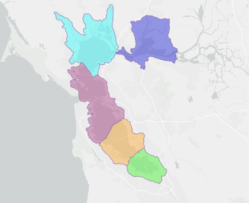
The WRMP Subembayment were created from grouping Operational Landscape Units (OLUs) into divisions of the San Francisco Bay/Lower San Francisco Estuary that were similar from a natural process and ecological standpoint. This Subembayment layer is intended to be used for reporting and planning purposes for the WRMP. The divisions are most closely aligned with the subregions defined in the Baylands Ecosystem Habitat Goals report. Geometries from the OLU or Sediment for Survival Subembayment layers were followed where possible.
Decisions in the grouping of Subembayments to note:
- Carquinez Strait OLUs (Carquinez North and Carquinez South) were grouped with the Suisun Bay Subembayment following the grouping in the Bayland Ecosystem Habitat Goals Subregions and to group more ecologically similar areas.
- Colma-San Bruno OLU was grouped with Central Bay Subembayment following the grouping in the Bayland Ecosystem Habitat Goals Subregions.
- Winter Island and Brown's Island were included in the Suisun Bay Subembayment. In order to be consistent with other Primary OLU boundaries, a 5m SLR extent was modeled and a 300m buffer added.
- For the WRMP Subembayments, the deep water portions of the Bay were manually split and merged with each respective subembayment.
Background
In 2024, there were a number of related GIS layers and previous groupings of the SF Bay that were taken into account when creating this layer. Below you can find descriptions of 3 of the most important layers and how they differ from the WRMP Subembayment layer.
Bayland Ecosystem Habitat Goals Subregions: Bayland Ecosystem Habitat Goals Project report. The Baylands Ecosystem Habitat Goals defined 4 subregions, South Bay, Central Bay, North Bay, and Suisun Bay. With the exception of the additional split separating South Bay and Lower South Bay, the subembayment division largely follows the same subregion delineation used in the Baylands Ecosystem Habitat Goals Project.
Sediment for Survival Subembayments: This layer was based on OLUs from the Adaptation Atlas. This is a similar layer to WRMP Subembayments, but has a different division between Central and South Bay as Colma-San Bruno OLU was grouped into the South Bay instead of the Central Bay as it is in the WRMP Subembayments layer. Also it groups Carquinez Strait (north and south) into San Pablo Bay instead of in Suisun Bay subembayments, unlike the WRMP Subembayments layer. Winter Island and Brown's Island were included in Suisun Bay Subembayment. The delineation of these subdivisions was based on USGS sediment flux monitoring locations to enable sediment budget calculations.
Operational Landscape Units (OLUs) from the Adaptation Atlas: San Francisco Bay Shoreline Adaptation Atlas. Adaptation Atlas Data includes the original Operational Landscape Units. These OLUs do not include Winter and Brown's Islands on the edge closest to the Sacramento-San Joaquin Delta. Note that Winter Island and Brown's Island were not included in an OLU in the original set of OLUs.
Wetlands Regional Monitoring Program (WRMP). 2025. "WRMP Subembayments v1.1" Accessed [date retrieved]. https://www.sfei.org/data/wrmp-subembayments-v11.
This file is part of WRMP Subembayments.
WRMP Subembayments is free data: you can redistribute it and/or modify it under the terms of the GNU General Public License as published by the Free Software Foundation, either version 3 of the License, or (at your option) any later version.
WRMP Subembayments is distributed in the hope that it will be useful, but WITHOUT ANY WARRANTY; without even the implied warranty of MERCHANTABILITY or FITNESS FOR A PARTICULAR PURPOSE. See the GNU General Public License for more details.
More information about GNU General Public License is available at http://www.gnu.org/licenses/. SFEI data are available without restriction upon use with the following caveats. Prudent usage, knowledge of the data quality, and professional courtesy should all be considered in obtaining and using SFEI data. As this dataset is NOT a survey document, neither use it as such nor use it beyond the limits of the source scale. Please read and fully comprehend all available metadata prior to data use. SFEI requests that the use of these data in any map, publication, or report should include citation of the data source(s) used and give proper attribution and credit to the originators of the data. Questions about SFEI data may be directed to the GIS Manager, at 510-746-7334.