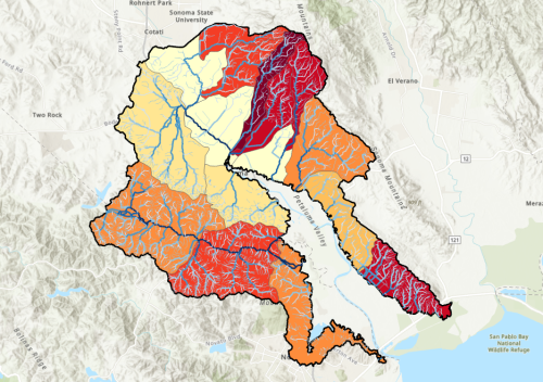
These data layers accompany the 2025 Petaluma River Watershed Sediment Source Assessment, part of the San Francisco Estuary Institute’s (SFEI) larger Sediment Solutions project funded by the U.S. EPA and Sonoma Water. Information on the project can be found at www.sfei.org/sedimentsolutions. These datasets are intended to allow for use of the mapped sediment supply data displayed in the sediment source assessment report, as well as define boundary areas for subcatchments assessed in the project.
Please see the Petaluma River Watershed Sediment Source Assessment for more information.
San Francisco Estuary Institute (SFEI). 2025. "Petaluma River Watershed Sediment Source Assessment Data: Petaluma_watershed_boundary." Accessed [date retrieved]. https://www.sfei.org/data/petaluma-river-watershed-sediment-source-asse…
San Francisco Estuary Institute (SFEI). 2025. "Petaluma River Watershed Sediment Source Assessment Data: Petaluma_watershed_subcatchments." Accessed [date retrieved]. https://www.sfei.org/data/petaluma-river-watershed-sediment-source-asse…
San Francisco Estuary Institute (SFEI). 2025. "Petaluma River Watershed Sediment Source Assessment Data: Petaluma_channels_erosion_rates." Accessed [date retrieved]. https://www.sfei.org/data/petaluma-river-watershed-sediment-source-asse…
This file is part of Sediment Solutions data.
Sediment Solutions data are free data: you can redistribute them and/or modify them under the terms of the GNU General Public License as published by the Free Software Foundation, either version 3 of the License, or (at your option) any later version.
Sediment Solutions data are distributed in the hope that they will be useful, but WITHOUT ANY WARRANTY; without even the implied warranty of MERCHANTABILITY or FITNESS FOR A PARTICULAR PURPOSE. See the GNU General Public License for more details.
More information about GNU General Public License is available at http://www.gnu.org/licenses/.SFEI data are available without restriction upon use with the following caveats. Prudent usage, knowledge of the data quality, and professional courtesy should all be considered in obtaining and using SFEI data. As this dataset is NOT a survey document, neither use it as such nor use it beyond the limits of the source scale. Please read and fully comprehend all available metadata prior to data use. SFEI requests that the use of these data in any map, publication, or report should include citation of the data source(s) used and give proper attribution and credit to the originators of the data. Questions about SFEI data may be directed to the GIS Manager, at [email protected].
Disclaimer: In no event shall the creators, custodians, or distributors of this information be liable for any damages arising out of its use. These data are not legal documents or of survey or engineering quality and are not intended to be used as such. Although effort has been made to produce error-free and complete data, all geographic information has limitations due to the scale, resolution, date and interpretation of the original source materials. Data completeness also varies by data availability for specific dataset attributes. Data may be subject to change without prior notification. These maps are not to be used for purposes of accessing any locations or properties depicted, and distribution of these maps in no way implies any approval or authority to enter the subject properties, unless otherwise indicated. Interested parties must contact the appropriate landowner for current information on property access and condition of features. We request that the use of these data in any map, publication, or report should cite the data source(s) used and give proper attribution and credit to the originators of the data.