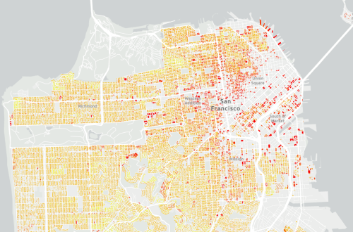
This dataset provides building-level estimates of population and selected demographic characteristics, for the nine Bay Area counties (Alameda, Contra Costa, Marin, Napa, San Francisco, San Mateo, Santa Clara, Solano, and Sonoma), by redistributing American Community Survey (ACS) data (2017-2021) from census block groups to individual residential buildings. The purpose of this dataset is to support planning, analysis, and decision-making efforts that require a more spatially realistic representation of where people live than is available from census geographies alone.
By integrating land use, building footprints, and housing-type-specific occupancy information, the dataset improves upon uniform, area-based population allocation methods and reduces the misallocation of population to non-residential, undeveloped, or protected lands. The resulting estimates provide a finer spatial resolution of population and demographic patterns while maintaining consistency with published ACS totals.
These data are intended for regional or subregional analyses and are not designed to represent exact conditions at the parcel or individual building level.
San Francisco Estuary Institute (SFEI). 2025. "Bay Area Dasymetric Population Estimates." Accessed [date retrieved]. https://www.sfei.org/data/bay-area-dasymetric-population-estimates
This file is part of Bay Area Dasymetric Population Estimates.
The Bay Area Dasymetric Population Estimates is free data: you can redistribute it and/or modify it under the terms of the GNU General Public License as published by the Free Software Foundation, either version 3 of the License, or (at your option) any later version.
The Bay Area Dasymetric Population Estimates dataset is distributed in the hope that it will be useful, but WITHOUT ANY WARRANTY; without even the implied warranty of MERCHANTABILITY or FITNESS FOR A PARTICULAR PURPOSE. See the GNU General Public License for more details.
More information about GNU General Public License is available at http://www.gnu.org/licenses/.SFEI data are available without restriction upon use with the following caveats. Prudent usage, knowledge of the data quality, and professional courtesy should all be considered in obtaining and using SFEI data. As this dataset is NOT a survey document, neither use it as such nor use it beyond the limits of the source scale. Please read and fully comprehend all available metadata prior to data use. SFEI requests that the use of these data in any map, publication, or report should include citation of the data source(s) used and give proper attribution and credit to the originators of the data. Questions about SFEI data may be directed to the GIS Manager, at 510-746-7334.