The City of San Francisco is the ancestral homeland of the Yelamu, an independent tribe of the Ramaytush Ohlone. Until the arrival of European colonists in the 18th century, the Yelamu and their ancestors were the inhabitants and stewards of this land. Although the Yelamu did not leave written documentation prior to Euro-American colonization, archaeological research and early Spanish accounts provide many insights into the Yelamu culture and the landscape they inhabited and stewarded.
There currently is no single, authoritative ethnohistorical record of the Yelamu, resulting in a lack of knowledge and resources to inform culturally-sensitive decisions, planning, and educational materials. Mapping Yelamu's Historical Landscape (MYHL), a collaboration between SFEI, the Association of Ramaytush Ohlone, and the Exploratorium, supports the development of a thorough ethnohistory, including an accurate and accessible map of village locations and other cultural sites within the boundaries of San Francisco. These products will enable cultural history, knowledge, and traditions to be incorporated into City and project planning, design, and management.
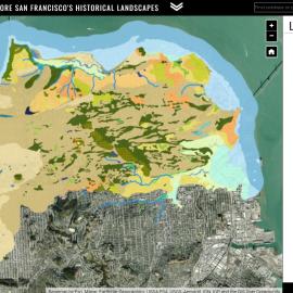
Generating a detailed ethnohistorical account of the Yelamu relies on mapping historical landscape features. MYHL builds on existing historical ecology research, developed through Hidden Nature SF and Next Generation Urban Greening, to extend the mapping of historical landscape features, such as habitat types and creeks, to remaining portions of San Francisco not covered by prior projects.





Other Individual Contributors

SFEI and our partners from the Exploratorium, the San Francisco Department of the Environment, and the Presidio Trust were joined live by over 400 participants for a conversation around the nature, both past and present, that is hidden in plain sight in San Francisco.