
Green infrastructure (GI), such as permeable pavement, rain gardens, tree-well planters, or bioswales, can be used as cost-effective, resilient approaches to managing stormwater at its source while delivering environmental, social, and economic benefits for your community. GreenPlan-IT is a versatile open-source toolset that helps aid municipalities with their efforts to plan and evaluate the placement of green infrastructure in the landscape and track the effectiveness of these installations in reducing stormwater run-off, PCB, and mercury in receiving waters. A component of the Green Plan Bay Area project, GreenPlan-IT is a planning level tool that was developed by SFEI in collaboration with the San Francisco Estuary Partnership, a technical advisory committee, pilot partners, and BASMAA to provide Bay Area municipalities with the ability to evaluate multiple management alternatives using green infrastructure for addressing stormwater issues in urban watersheds. GreenPlan-IT combines sound science and engineering principles with GIS analysis and optimization techniques to support the cost-effective selection and placement of Green Infrastructure (GI) at a watershed scale. Tool outputs can be used to develop quantitatively-derived watershed master plans to guide future GI implementation for improving water quality in the San Francisco Bay and its tributary watersheds.
Structurally, the GreenPlan-IT comprises four components:
- a GIS-based Site Locator Tool to identify potential GI sites;
- a Modeling Tool that quantifies anticipated watershed-scale runoff and pollutant load reduction from GI sites;
- an Optimization Tool that uses a cost-benefit analysis to identify the best combinations of GI types and number of sites within a watershed for achieving flow and/or load reduction goals;
- and a Tracker Tool that helps municipalities to track their placement of green infrastructure in the landscape via an online tool. Once placed on the map, then the features enter a portfolio to calculate total PCB, mercury, and stormwater flow reductions.
The four tool components were designed as standalone modules to provide flexibility and their interaction is either through data exchange, or serving as a subroutine to another tool.
Key Features
Green Infrastructure is a water management approach that aims to restore watershed processes and function. In aggregate, Green Infrastructure can be an effective stormwater management approach for reducing runoff and contaminant loads from urban and developed areas. GreenPlan-IT is a GIS and modeling, planning level toolkit to aide municipalities in identifying the optimal combination of Green Infrastructure features and sites for achieving predetermined and desirable reduction outcomes at the watershed scale. By managing runoff close to its source through smart Green Infrastructure placement, we can enhance the local environment, protect public health, and improve community livability.
Feasibility Module (Locator Tool)
GreenPlan-IT has a customizable Arc-GIS based site locator tool for identifying, ranking, and mapping potential Green Infrastructure locations within watersheds. Outputs include maps with feasible Green Infrastructure locations, relatively ranked according to customizable weighting and ranking of data inputs.
Effectiveness Module (Modeling Tool)
The modeling tool is a hydrologic and water quality tool that quantifies reductions in stormwater and associated pollutants that result from optimal placement of Green Infrastructure in a particular watershed.
Cost/Benefit Analysis (Optimization Tool)
The optimization tool uses a cost-benefit analyses to identify the best combinations of Green Infrastructure types and number of sites within a watershed for achieving load and volume reduction goals.
Landscape Visualization (Tracker Tool)
The latest module helps municipalities to track their placement of green infrastructure in the landscape via an online tool. Once placed on the map, then the features enter a portfolio to calculate total PCB, mercury, and stormwater flow reductions.
Tool Outputs and Municipal Plans
Municipal planners can use toolkit outputs in combination with other local knowledge such as information on flood prone areas, areas for redevelopment, and educational opportunities to identify optimized Green Infrastructure placement. The toolkit outputs can be incorporated directly into municipal planning documents for longer-range adoption of strategic Green Infrastructure implementation.
Tool Components
The following high-level overview introduces you to the various parts of the toolset.
Site Locator Tool
GreenPlan-IT Site Locator Tool
What is the Site Locator Tool?
The GIS Site Locator Tool is a flexible planning level tool, within the Green Plan-IT Toolkit, to aid municipal planners with strategic Green Infrastructure (GI) implementation at the watershed scale. The tool can be used to create custom maps that identify and rank potential GI locations. The tool incorporates many regional, publicly available data layers and has built in flexibility to add local data layers to best identify suitable locations and rankings of GI. The site locator tool has end-user flexibility with access to the tool’s engine resulting in an iterative tool that can be fine-tuned as additional local data, or data with better resolution, become available.
What can the Site Locator Tool do?
The GIS Site Locator Tool allows the user to create custom outputs for their municipality and allows for multiple levels of refinement of outputs based on available local data. Local GIS data can be added to the Tool to increase the Tool’s delivery of priority GI locations. The tool can create maps of suitable locations for different GI types. The GIS Site Locator Tool allows for custom ranking of local and regional layers according to local priorities and municipal or County plans. Suitable GI locations are distinguished by both private and public designation. The tool also has flexibility to remove unsuitable areas for GI placement consideration, such as riparian or wetland areas, by adding exclusion buffers to the data layers.
Who should use the Site Locator Tool?
The GIS Site Locator Tool is designed for city and County planners to organize and synthesize available data for planning level efforts. The Tool outputs, in combination with other local knowledge such as flood prone areas, areas for redevelopment, educational and funding opportunities can be used to identify and plan for optimized GI placement.
How does the Site Locator Tool work?

Modeling Tool
GreenPlan-IT Modeling Tool
The GreenPlan-IT Modeling Tool is a spatially distributed hydrologic and water quality model that simulates watershed processes and LID performance. Built upon the publicly available EPA Storm Water Management Model (SWMM) version 5.0, the modeling tool can be used to establish baseline conditions as well as evaluate relative effectiveness of implementing LID across different areas within a watershed, based on the potential of each LID type for reducing contaminant loads and runoff volume. Within the GreenPlan-IT toolkit, the Modeling Tool serves as a bridge between the LID Site Locator Tool and the Optimization Tool - it takes potential LID sites identified through the LID Site Locator Tool as constraints and simulates the performance of various LID combinations created by the Optimization Tool.
Capacities
The Modeling Tool can simulate the generation, fate and transport of stormwater runoff and associated pollutants from landscape, as well as resulting flow and pollutant loading reduction as they pass through various LIDs. Municipalities can use the tool to 1) establish the baseline conditions through the characterization of the modeled watershed before any new management activities are implemented; 2) identify high-yield runoff and pollution areas; and 3) more importantly, quantify any reduction made from LID implementation by performing before and after LID simulation. SWMM 5 is currently capable of simulating the hydrologic performance of seven types of LIDs. As with most modeling exercises, the model is calibrated using local data before it can be used by municipalities to simulate LID scenarios for their local watersheds.
Applications
The Modeling Tool is intended for use by city engineers and planners to develop and evaluate various management scenarios at the watershed scale, alone or within the Toolkit. The model outputs provide quantitative information on flow, pollutant loading, and reductions from management actions for studied watersheds, and can assist in developing watershed master plans or city and county general plans for stormwater runoff or pollutant control.
Download the Modeling Tool
The SWMM installation program, user’s manual, as well as source codes are available at EPA SWMM website. Users can follow the instructions provided at this site to download and install SWMM on a PC. In particular, users will need to download:
- Self-extracting installation program for SWMM5.1.007 (EXE). Run this .exe file to install SWMM on your PC. The detailed instructions on model installation and pertinent software/hardware requirements are provided in the SWMM user manual.
- SWMM5.0 User’s Manual (PDF). This is the main SWMM document that provides step-by-step instructions on how to set up and get started with SWMM, as well as detailed descriptions on SWMM structure and various functionalities and options.
In addition, users are strongly encouraged to download and go through ‘SWMM Applications Manual (ZIP)’ to help expedite their use of SWMM. It contains nine worked-out examples that illustrate how to use SWMM to model some of the most common types of stormwater management and design problems. In some cases, users may also want to download SWMM source code to meet their specific needs.
Optimization Tool
GreenPlan-IT Optimization Tool
The Optimization Tool is intended to assist stormwater managers with selecting the best LID placement alternatives among the many options available that satisfy user-defined management targets. It uses an evolutionary optimization technique (Non-dominated Sorting Genetic Algorithm II) to evaluate the benefits (runoff and pollutant load reductions) and costs associated with various LID implementation scenarios (location, number, type, and size of LIDs) and identify the most cost-effective options for achieving desired flow mitigation and pollutant reduction at minimum cost. The tool incorporates site information from the GIS Site Locator Tool and local cost information, and is interacted with the modeling tool during the search process in an iterative and evolutionary fashion to systematically generate viable LID scenarios and compare their performance.
Capacities
The Optimization Tool provides critically needed support to stormwater managers at all levels for selection and placement of LID at strategic locations in urbanized watersheds for stormwater runoff or pollutant control. The tool develops and evaluates alternative management scenarios and identifies the optimal combination of LID location, type, size to meet specific management goals on the basis of cost and effectiveness. The tool generates a cost- and pollutant-reduction effectiveness relationship that provides quantitative information on a range of optimal LID solutions for achieving various reduction goals at minimum costs to facilitate decision making. The outputs of the tool can be overlaid with the LID opportunity maps produced by the Site Locator Tool to create a map /tabular output of suitable and most effective locations for LID implementation for achieving specific reduction objectives.
Applications
The Optimization Tool is designed to help local watershed planning agencies to develop stormwater management plans and coordinate watershed-scale investments to meet their program needs. It is intended for knowledgeable users familiar with LIDs and the technical aspects of watershed modeling. The tool outputs, combined with other site specific information and management requirements, can be used to develop watershed-scale Green Infrastructure master plans.
Tracker Tool
GreenPlan-IT Tracker Tool
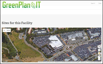
At a very basic level, the GreenPlan-IT Tracker is a web-based tool (currently under revision) that accounts for the impact of implemented Green Infrastructure within a municipal, county-wide, or user-defined footprint. It is an extensible custom database designed to record, display, and exchange data regarding currently installed green infrastructure sites.
Adding Value to the Collected Information
The Tracker is more than a simple database. It helps assess performance of the installations as well.
The GreenPlan-IT Tracker uses the same SWMM modeling engine as that build into the GreenPlan-IT Modeler to assemble a profile of Green Infrastructure installations and determine their collective effectiveness in reducing stormwater run-off, as well as attenuate PCB and mercury pollution. In this way, the GreenPlan-IT Tracker reports on the location and details of GI implementation while also reporting their cumulative programmatic outcomes.
Product Details
- Records and display information about GI implementation for individual sites
- Aggregates information across multiple sites within a city or area of interest
- Generates standardized reports to track progress for regulatory compliance
- Calculates effectiveness based on modeling outputs
- Illustrates the broader lifecycle of GI implementation and outcomes using score cards and key information
Current Status
The tool was released in Jan 2019 for Bay Area programs. If you would like an account, please contact us at [email protected].
Accessing the GreenPlan-IT Tracker Tool
The GreenPlan-IT Tracker is a web-based application, not a file to be downloaded onto your desktop. It is currently offline to facilitate its upgrade to the latest version of the software.
It was released in January 2019 for your use. Please contact [email protected] if you have a need to track and plan your green stormwater infrastructure.










Effective implementation of urban greening strategies is needed to address legacies of landscape change and environmental degradation, ongoing development pressures, and the urgency of the climate crisis.

San Francisco Bay and its watersheds are polluted by legacy polychlorinated biphenyls (PCBs), resulting in the establishment of a total maximum daily load (TDML) that requires a 90% PCB load reduction from municipal stormwater.
GreenPlan-IT is a planning level tool that was developed by SFEP and SFEI with support and oversight from BASMAA to provide Bay Area municipalities with the ability to evaluate multiple management alternatives using green infrastructure for addressing stormwater issues in urban watersheds.
Structurally, the GreenPlan-IT is comprised of three components: (a) a GIS-based Site Locator Tool to identify potential GI sites; (b) a Modeling Tool that quantifies anticipated watershed-scale runoff and pollutant load reduction from GI sites; and (c) an Optimization Tool that uses a cost-benef
This technical memo describes the purpose, functions, and structure associated with the newest addition to the GreenPlan-IT Toolset, the GreenPlan-IT Tracker. It also shares the opportunities for further enhancement and how the tool can operate in concert with existing resources.


SFEI awarded over $7 million for Bay restoration and community partnerships
SFEI is the lead on three US Environmental Protection Agency Water Quality Improvement Fund grants totaling more than $7M.

We offer you a simple tool that we created for our 75-person “work community” to help each other that yours might also find helpful. This is a mapping tool, which we call Care in the Time of Corona. It helps us locate and efficiently provide the support that our SFEI staff might offer one another. Quite simply, it facilitates assistance within our organization so that people can help their colleagues deal with challenges of this unprecedented situation. The errands, food, medicine, or even compassionate discussion they need can be addressed through a convenient and filterable map. We hope this guidance and the spirit behind it will help support your community and sustain a sense of well-being as we meet this challenge head on together.
SFEI's journal article on Green Stormwater Infrastructure featured as the Editor's Choice
A team led by Dr. Jing Wu penned a paper in January on using Green Stormwater Infrastructure to protect the Bay from PCBs and other contaminants.
GreenPlan-IT Tracker Released to the public
Municipalities across the state and beyond are carefully planning and implementing green infrastructure in their developed landscape to restore key aspects of the natural water cycle.
GreenPlan-IT Site Locator Tool v2.1 Update
SFEI’s GreenPlan-IT is a planning level toolkit which help municipalities with green infrastructure planning, assessment and reporting.
Working in partnership primarily with the City of Richmond and the County of Contra Costa County, SFEI is developing a new GreenPlan-IT Tracker.
GreenPlan-IT featured in the newsletter of the National Water Quality Monitoring Council
GreenPlan-IT, a toolset created in a collaboration with SFEP, US EPA, and local partners, has been featured in the newsletter of the National Water Quality Monitoring Council, which has been distributed broadly to subscribers throughout the nation and beyond.
GreenPlan-IT Toolbox evolving quickly to meet increased demand
With the conclusion of the first round of funding for the Green Plan Bay Area project http://www.sfestuary.org/our-projects/water-quality-improvement/greenplanning/, SFEI produced GreenPla
Working in partnership primarily with the City of Richmond and the County of Contra Costa County, SFEI is developing a new GreenPlan-IT Tracker.