California Rapid Assessment Method for Wetlands (CRAM) HDC and CDF Data
This page provides public access to tabular datasets for the CRAM Habitat Development Curves (HDCs) and statewide and regional probablity based ambient survey Cumulative Distribution Function estimate curves (CDFs) found in EcoAtlas.
What is an HDC?
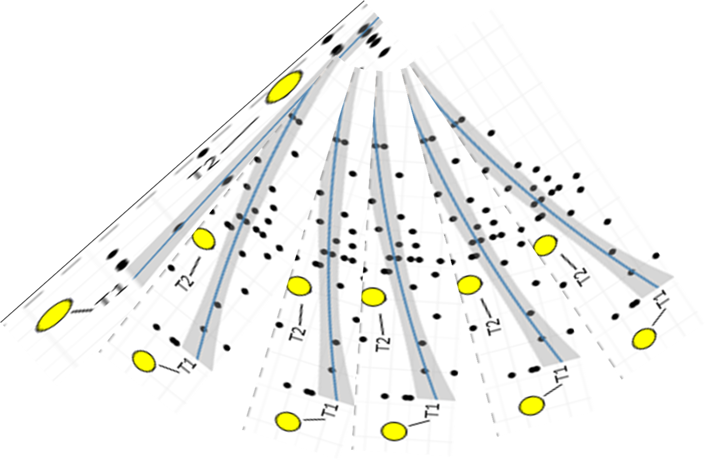
Early guidance by US Environmental Protection Agency (USEPA) for wetland restoration planning recommends the use of performance curves, also known as Habitat Development Curves (HDCs), to forecast and evaluate project performance relative to desired or reference conditions (Kentula et al. 1992). Ideally, HDCs indicate the condition a project is likely to achieve at any future date after it is constructed.
Wetland HDCs are developed by assessing conditions of multiple projects of different age and comparing them to natural wetlands that represent the intended endpoints of projects conditions. Wetland HDCs are based on the assumption that the developmental trajectory of any given wetland can be estimated by the developmental stages of other wetlands of the same kind but differing ages that in aggregate represent the entire developmental timeframe. The key element of a useful HDC is a standardized dataset that chronicles temporal changes in habitat conditions.
To date CRAM HDCs have been developed for statewide Coastal and San Francisco Bay Area estuarine wetlands, statewide depressional wetlands, and Central Valley vernal pool systems (also called vernal pool complexes).
How to access the HDC CRAM assessment data:
The downloadable Excel file at the bottom of this webpage contains the HDC data by region and wetland type.
The CRAM HDCs plots are also interactively accessible within individual habitat projects in EcoAtlas’s Project Tracker module. From EcoAtlas' main page select "Projects" and type in (or select) the project name of interest. A separate "Habitat Development Curves" tab within the project page allows the user to see a project’s CRAM scores overlaid on the corresponding wetland HDC to compare project scores to the expected development curve of the same wetland type. However, please note that the project must have a project completion date and CRAM assessments located within the project's footprint in order to be plotted on the curve. The project end-date serves as the time-zero to plot the CRAM scores along the x-axis of the curve.
Kentula, ME, RP Brooks, SE Gwin, CC Holland, AD Sherman and JC Sifneos. 1992. Wetlands: an approach to improving decision making in wetland restoration and creation. Corvallis, OR: Wetlands Research Program, U.S. Environmental Protection Agency, Environmental Research Laboratory.
What is a CRAM CDF?
The primary outputs of a probabilistic baseline survey employing CRAM and the EPA’s Generalized Random Tessellation Stratified (GRTS) survey design and analysis methodology are CDF estimate plots and tables. A CDF curve estimates the proportion of the surveyed resource (e.g. stream miles within a watershed or ecoregion, or wetland habitat area within the Central Valley region) that is less than or equal to any given CRAM Index or Attribute score with a known level of confidence. CDFs based on CRAM provide resource managers a standardized way to evaluate and compare wetland mitigation project conditions to local watershed or regional ecological conditions by allowing them to place project condition scores on the CDF curves and see if the project is (for example) above or below the 50th percentile score of streams or wetlands in the watershed or region.
CDFs do not represent the condition of any specific site but provide a landscape level (or regional context) for comparing individual sites to overall ambient conditions. CDF outputs are both tabular and graphical, and can be summarized using the standard CRAM condition classes to characterize the proportions of surveyed resources that are in poor, fair, and good conditions.
How to access the CDF estimate data?
The downloadable Excel fie at the bottom of this webpage contains the CDF results for all the ambient condition surveys employing CRAM.
The CRAM CDF plots are also interactively accessible through EcoAtlas' Landscape Profile tool. From EcoAtlas' main page select "Map" or click on the region of interest on the map. Next select the 'Show Tools' button at the top right corner of the screen (select "Landscape Profiles" and then the "Condition Profle"). EcoAtlas users can zoom into a project site that has been assessed using CRAM and see the project’s CRAM scores overlaid onto the regional CDF curve. This allows users to compare project scores relative to ambient conditions for the Central Valley region as a whole.
Type of Data:
Tabular data
Programs and Focus Areas:
Environmental Informatics Program
Resilient Landscapes Program
Wetland Monitoring & Assessment
Funders:
U.S. EPA Region 9
Santa Clara Valley Water District
CalTrans
Related Projects, News, and Events:
 Get on the curve: Habitat Development Curves help determine the performance of on-the-ground projects (News)
How do you know if the ecological conditions of your wetland project are aligned with expected rates of improvement?