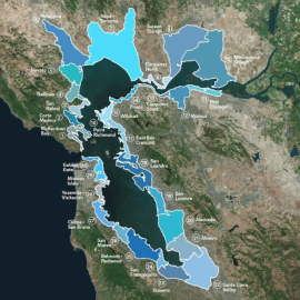
San Francisco Bay Shoreline Adaptation Atlas: Working with Nature to Plan for Sea Level Rise Using Operational Landscape Units
Abstract
As the climate continues to change, San Francisco Bay shoreline communities will need to adapt in order to build social and ecological resilience to rising sea levels. Given the complex and varied nature of the Bay shore, a science-based framework is essential to identify effective adaptation strategies that are appropriate for their particular settings and that take advantage of natural processes. This report proposes such a framework—Operational Landscape Units for San Francisco Bay.
Preferred Citation
Beagle, J; Lowe, J; McKnight, K; Safran, SM; Tam, L; Szambelan, SJ. 2019. San Francisco Bay Shoreline Adaptation Atlas: Working with Nature to Plan for Sea Level Rise Using Operational Landscape Units. SFEI Contribution No. 915. p. 255.
Published Document
| Attachment | Size |
|---|---|
| Adaptation Atlas (High Resolution) | 259.64 MB |
| Adaptation Atlas (Medium Resolution) | 84.6 MB |
| Adaptation Atlas (Low Resolution) | 20.93 MB |
Date Published
05/2019
DOI
10.13140/RG.2.2.22416.46083
ISBN Number
978-1-950313001-3
Programs and Focus Areas
Resilient Landscapes Program
Baylands & Shoreline Resilience
Adaptation Science
Export Links