Sonoma County Riparian Corridor Mapping Pilot Study Project

Through an EPA-funded Wetland Development Grant, Permit Sonoma, County of Sonoma (County), in coordination with the Sonoma Ecology Center (SEC), the San Francisco Estuary Institute (SFEI), and a Technical Advisory Committee (TAC), developed the Sonoma County Riparian Corridor Mapping Pilot Study (Pilot Study). The Pilot Study is Permit Sonoma’s initial step in the development of an automated GIS method to update its riparian mapping database countywide using LiDAR derived stream data.
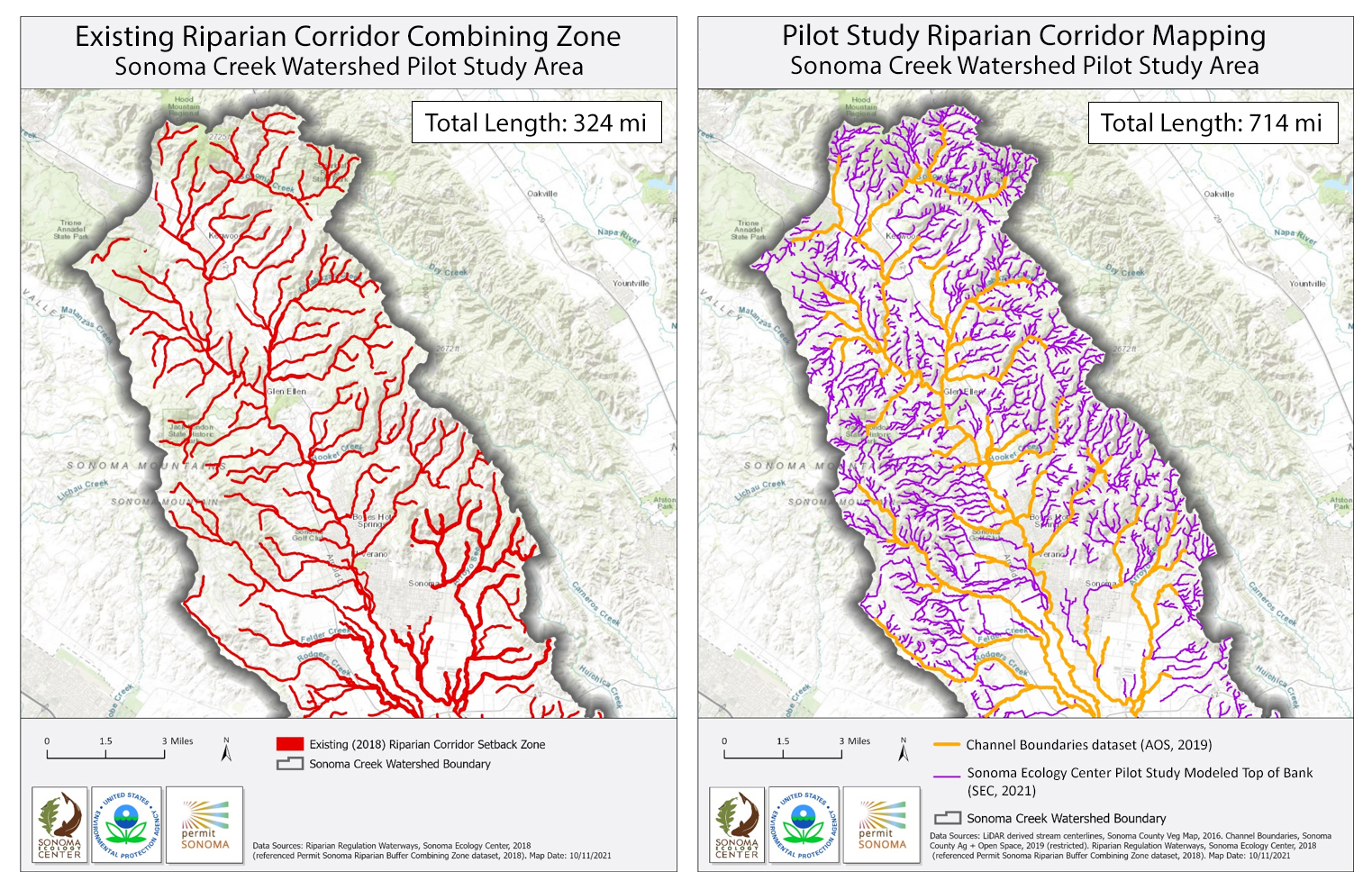
County riparian protection is currently achieved through application of its 2014 Riparian Corridor Combining Zone ordinance. The ordinance establishes riparian corridor buffer (setback) widths at 50, 100, or 200 feet as measured from the top-of-bank. Activities or improvements within these setback areas require County approval through its regulatory permitting process.
The intent of the Pilot Study was to develop a method for updating the riparian corridor database with more current and accurate stream centerline data and to develop an automated method of modeling the top-of-bank from which to map the riparian corridor buffer setback (50, 100, or 200 feet). The existing Riparian Corridor Combining Zone database is based on USGS blue-line stream data dating from the 1980s and riparian buffer setbacks are measured from the stream centerline (rather than the top-of-bank, as stipulated in the County ordinance). More accurate LiDAR-derived digital elevation model (DEM) and hydrology data are now available, as well as potential methods for modeling top-of-bank.
The Sonoma Creek Watershed was used as the Pilot Study Area. Multiple methods to develop a top-of-bank model were evaluated, including RipZET, Height Above River (HAR), Relative Slope Analysis (RSA), and the County’s recently updated Vital Lands Initiative - Riparian Mapping Project: Channel Boundaries dataset (AOS, 2019). Based on input from the Pilot Study’s TAC and the newly available Channel Boundaries data, two different models were selected for the Pilot Study Area.
For watersheds 500 acres or greater in size, the Channel Boundaries dataset modeling top-of-bank was selected. Because the Channel Boundaries modeling method was not applicable to or available for smaller (< 500 acres) watersheds, and because RipZET, HAR, or RSA were not completely suitable for automated modeling of top-of-bank, SEC developed a model using a regional curve analysis. Based on 2016 LiDAR-derived stream data, SEC attributed flow accumulation values (to calculate the upstream catchment area for stream segment classes) and applied the Collins and Leventhal (Collins and Leventhal, 2013) regional curve regression equations to calculate Bankfull Width (BFW) and Flood Prone Width (FPW) to model top-of-bank. Various BFW and FPW regional curve models were compared with HAR boundaries and areas that overlapped with the Channel Boundaries data, and then field verified with top-of-banks in watersheds < 500 acres. While FPW was potentially overly protective in watersheds > 200 acres, and potentially slightly less protective in watersheds < 200 acres, it appeared the best fit and the most protective single method for modeling top-of-bank within all watersheds < 500 acres. Together, the Channel Boundaries dataset and SEC’s regional curve dataset provided modeled top-of-bank within the entire Pilot Study Area.
Issues for consideration in future studies include:
- Addressing data gaps between the Channel Boundaries and SEC regional curve model data;
- Refining field study verification methods for the SEC regional curve model;
- Performing additional verification of the SEC regional curve model data using intensive HAR analysis and additional field verification;
- Based on additional field verification, potentially using different (FPW vs BFW) regional curve models for different sized watersheds; and
- Applying the SEC regional curve model to additional landscapes and stream types throughout Sonoma County.
Dates:
2017 to 2021
Funders:
Associated Staff:
Deborah Waller, Permit Sonoma
Noah Najarian, Permit Sonoma
Shelly Bianchi-Williamson, Permit Sonoma
Steve Lee, Sonoma Ecology Center
Project Site:
Programs and Focus Areas:
Environmental Informatics Program