Spreadsheet Model for Estimating Loads from Small Tributaries
Overview
To accurately assess total contaminant loads entering San Francisco Bay, it is necessary to estimate loads from local watersheds. Presently Hg loads entering the Bay from urban stormwater described in the San Francisco Bay TMDL have been estimated by the Water Board by combining BASMAA bed sediment data with estimates of regional suspended sediment loads. In the case of PCBs, the mass loads in the Bay TMDL were derived from scaling existing data by area (from the Guadalupe and Coyote Creek watershed) up to the region as a whole. Although these methods were appropriate for initial planning and TMDL development, part of the implementation plan of these TMDLs is to improve estimates of regional scale loads and to assess how these loads might be reduced. These needs are now reflected in the municipal regional stormwater permit (MRP) and in the second and fourth questions of the RMP Small Tributary Loading Strategy (STLS).
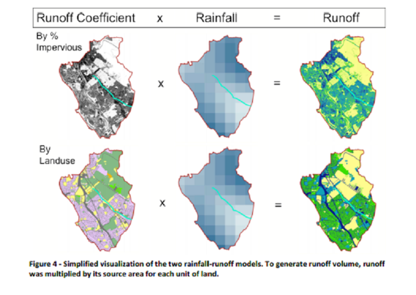
Spreadsheet models of stormwater quality provide a useful and cost-efficient tool for estimating regional scale watershed loads. These models are based on the simplifying assumption that unit area runoff for homogeneous sub-catchments have constant concentrations, and thus have advantages over models such as HSPF and SWMM that require large calibration data sets which are expensive to collect and compile. Such a model was developed for the Bay Area previously (Davis et al., 2000); however, at that time, there were only local land use-specific data on pollutants of concern (POCs) for a drought period late 1980s and early 1990s, and there were no local data on Hg and PCBs. More recently, a spreadsheet model was developed for a watershed in Los Angeles that predicted mass emissions to within 8% of measured Zn loads and described options for loads reduction through a focus on high leverage areas (Ha and Stenstrom, 2008).
The overall objective of this proposed study is to calculate mass emissions for the local watersheds draining into the San Francisco Bay, to provide the basis for refined annual load estimates. A GIS-based model is being developed to calculate stormwater volumes and POC loads on a long-term average monthly basis. (Eventually the model should operate on a storm event basis, but a massive precipitation data compilation effort will be necessary to achieve this on a regional scale.) In the face of limited land use-specific POC concentration data for the Bay Area, recent stormwater literature will be used to provide these estimates. In 2010, a project was conducted that developed the rationale and plan for land use-specific monitoring and loads estimates. In 2011, substantial effort was made to monitor multiple watersheds to better understand the variation of stormwater loads based on watershed types. These advances in modeling and monitoring made it possible to make great improvements in the spreadsheet model and the first dynamic model (being developed for the Guadalupe watershed due to the richness of the local data set). The ultimate objective of both of these models is to improve regional loads estimates and to provide tools to simulate (in time and space) the potential applications of suites of BMPs or management scenarios.
In 2011 the first version of the spreadsheet model was completed including: the base rainfall-runoff model, the collation of land use and source specific concentration data for pollutants of interest, and initial forays into sediment and pollutant models. Mathematical estimation methods were employed to develop land use specific event mean concentrations (EMCs) for analytes poorly characterized in the storm runoff literature.
Download a PDF Copy of the RWSM Year 1 Progress Report
In the second version of the model (Year 2), several calibration watersheds were added to ensure watershed characteristics spanned a wider range of imperiousness, gage records that were incongruent with land use/impervious data were removed, and land use categories were refined and the model was re-calibrated.
Download a PDF Copy of the RWSM Year 2 Progress Report
Applicable RMP Management Questions
The following RMP management questions will be addressed in this project.
- What are the sources, pathways, loadings, and processes leading to contaminant-related impacts in the Estuary?
- Q3C: What is the effect of management actions on loads from the most important sources, pathways, and processes?
- What is the watershed-specific and regional total water flow, load of sediment, and load contaminants entering the Bay from the urbanized small tributaries and non-urban areas draining to the Bay from the nine-county Bay Area and are there trends through time?
- What are the annual loads or concentrations of pollutants of concern from small tributaries to the Bay?
Staff Involved
Lester McKee, Michelle Lent, Alicia Gilbreath, and Sarah Pearce
Programs and Focus Areas:
Clean Water Program
Environmental Informatics Program