New data layers and Landscape Profile mode added to EcoAtlas
Dec 15, 2016
New data layers and Landscape Profile mode have been added to EcoAtlas (ecoatlas.org), an online tool for visualizing the abundance, diversity, and condition of wetlands, along with the project activities that are affecting the landscape. Enhancements include:
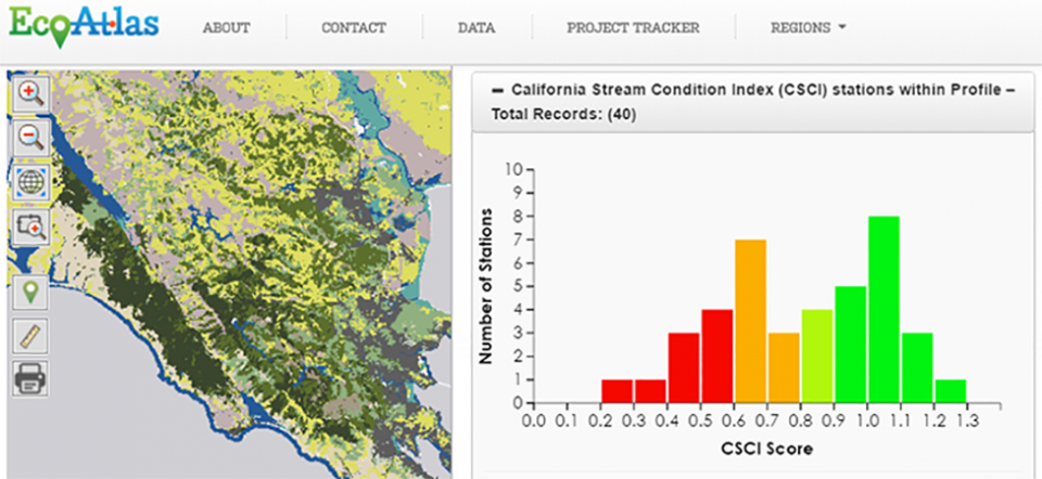
- The addition of CSCI and CALVEG data layers provide more information when evaluating an area of interest. The California Stream Condition Index (CSCI) is a statewide tool that translates complex data about individual benthic macroinvertebrates living in a stream into an overall measure of stream health. CALVEG is the USDA Forest Service’s comprehensive spatial dataset of existing vegetation cover over California. In EcoAtlas, CALVEG classifications are crosswalked to the California Wildlife Habitat Relationships to assist in better understanding, conserving, and managing California's wildlife.
- New CRAM and CSCI Landscape Profile generates a summary of the CSCI scores and CRAM CDFs for an area of interest. A cumulative distribution function (CDF) of CRAM scores represents the relative abundance of wetland conditions within the geographic extent. CRAM CDFs are being developed for California ecoregions and can be used to compare different areas of one wetland type to each other and the whole ecoregion. To-date, ecoregional CDFs have been developed for 6 out of 10 ecoregions for riverine wetlands.
- Improvements to the Habitat and CRAM filter tools allow users to better define the selection of projects or assessments they want to view on the map or download. Users can customize their map view by selecting the data layers relevant to answering their question, as well as download the data as a tabular or spatial file for further analysis.
- Inclusion of information on species of special status based on CNDDB in the Landscape Profile Tool provides useful information on both state and federally protected species. The Landscape Profile Tool uses publicly available data provided by CDFW’s California Natural Diversity Database (CNDDB) relating to the status and approximate locations of special status species of plants and animals in California. This information was temporarily unavailable while the web service was being updated.
- Separation of South Coast Water Boards on the home page map provides quicker access to projects and map for these regions. Initially combined as one South Coast Region, the three Water Boards comprising the South Coast (Los Angeles, Santa Ana, and San Diego) can now be accessed as separate regions.
These enhancements were funded by a USEPA Wetland Development Grant. For more information, visit ecoatlas.org, or contact [email protected] if you would like a demo of the new features.
Programs and Focus Areas:
Environmental Informatics Program
Resilient Landscapes Program
Wetland Monitoring & Assessment
Related Projects, News, and Events:
 Enhanced Landscape Profile Modes in EcoAtlas deliver new insights (News)
EcoAtlas is a mapping and geographic data visualization tool that continues to evolve to meet emerging needs. The toolset now includes new data layers and summaries to support the watershed planning, tracking, and reporting needs for the state. Within EcoAtlas, the Landscape Profile Tool provides easy access to summaries and data visualizations on watershed characteristics, ecological condition, habitat connectivity, and coastal habitats for an area of interest.
 EcoAtlas (Project)
EcoAtlas is a set of tools for generating, assembling, storing, visualizing, sharing, and reporting environmental data and information.
 EcoAtlas’ Landscape Profile Tool v2.0 (News)
The recent EcoAtlas release delivers new functionality and enhancements to the Landscape Profiler, a tool that summarizes ecological information at various spatial scales for assessment, planning, and reporting. Users can upload a KML file, edit the boundary, and save a polygon for their area of interest. Additional datasets are summarized in the Landscape Profile Report, including the revised 2011 National Land Cover Dataset, eelgrass survey data along the coast from Humboldt Bay to San Diego Bay, and percentages of languages spoken from the US Census data.