Sarah Lowe

Sarah Lowe, MS
Senior Environmental Scientist
Resilient Landscapes Program
Watershed Science & Management
Wetland Monitoring & Assessment
510-746-7384
Sarah joined the Regional Monitoring Program for Water Quality in San Francisco Bay (Bay-RMP) in 1994. During that time Sarah conducted science and managed projects and special studies related to contaminants, toxicity, and benthic ecology. Sarah later managed the Institute’s Data Management team, was the assistant Quality Assurance Officer, and Assistant Manager of the Bay-RMP for several years. In 2010 Sarah joined the Wetland Science Focus Area under the Resilient Landscapes Program and became a Senior Project Manager for projects whose focus is to support wetland monitoring and assessment using standardized science and technology in a watershed context for California's Wetland and Riparian Area Protection Policy. Ms. Lowe is the lead scientist at SFEI supporting an ongoing monitoring and assessment project with the Santa Clara Valley Water District's Safe Clean Water and Natural Flood Protection Program's- Priority D5 Project. That project is establishing a baseline condition assessment that characterizes the amount, distribution, and ecological condition of streams and wetlands in its five major watersheds using the WRAMP Framework (which includes a watershed approach, probability based survey designs recommended by the USEPA, and the California Rapid Assessment Method for wetlands). SFEI's Wetland Science Focus Area and Environmental Informatics Program staff coordinate with the California Wetland Monitoring Workgroup (a workgroup of the State's Water Quality Monitoring Council) to develop wetland monitoring protocols and online tools that support environmental data access, map-based visualization, and summaries about the distribution, abundance, and condition of aquatic resources across the state (EcoAtlas.org, CD3.org, and cramwetlands.org). Ms. Lowe received her M.S. in Environmental Management from the University of San Francisco and B.A. in Biology from the University of California at Santa Cruz.
Related Projects, News, and Events
 Enhanced Landscape Profile Modes in EcoAtlas deliver new insights (News)
EcoAtlas is a mapping and geographic data visualization tool that continues to evolve to meet emerging needs. The toolset now includes new data layers and summaries to support the watershed planning, tracking, and reporting needs for the state. Within EcoAtlas, the Landscape Profile Tool provides easy access to summaries and data visualizations on watershed characteristics, ecological condition, habitat connectivity, and coastal habitats for an area of interest.
 EcoAtlas Toolset Training and Outreach Plan (Project)
The California Wetland Monitoring Workgroup’s (CWMW) State Wetland and Riparian Area Monitoring Plan (WRAMP) requires information consistent with EPA’s Level 1‐2‐3 framework for monitoring and assessment of wetland and stream resources.
 Vision from the Skies: Using UAS Surveys to Monitor a Key Restoration Project (News)
At the McCosker Creek Restoration site, 3,000 linear feet of creek channel that previously had been flowing through underground culverts since the 1950s was daylighted and reconstructed. In addition, invasive and non native plants were removed and replaced with over 5,000 native plants. The restoration was also designed to support erosion control, and provide habitat for wildlife and aquatic species including rainbow trout, California red-legged frog and the Alameda whipsnake. This restoration work began in 2020 and concluded in 2023.
 California Aquatic Resource Inventory (CARI) (Project)
The California Aquatic Resources Inventory (CARI) is a Geographic Information System (GIS) based map of wetlands, streams, and riparian areas within California that is hosted online through EcoAtlas.
 Delta Aquatic Resource Inventory (Project)
DARI is the Delta Aquatic Resources Inventory of surface waters, wetlands and other aquatic resources in the Sacramento-San Joaquin Delta (Delta). The goal of the DARI project is to develop a geospatial inventory of aquatic resources that will be used as a common base map for the Delta. A similar mapping approach used to create the California Aquatic Resource Inventory (CARI) will be applied to provide a map of the aquatic resources and their associated attributes.
 California Pesticides: A Data Visualization Tool to Link Pesticide Use and Management to Water Quality (Project)
Despite California's data-rich environment, there are still many obstacles when trying to access and understand pesticide data at the nexus of water quality, ecological effects, and human health. We recognize a need to fill data gaps, not necessarily by collecting new data, but by better leveraging information already technically in the public domain. The goal of this project is to bring pesticide reporting, occurrence, and toxicity data together in ways that yield insights and meet the expressed needs of stakeholders in clear, efficient, credible, and repeatable ways.
The Riparian Zone Estimator Tool (RipZET) is a decision support tool developed by the San Francisco Estuary Institute and Aquatic Science Center for the California Riparian Habitat Joint Venture and the California Water Resources Control Board to assist in the visualization and characterization of riparian areas in the watershed context.
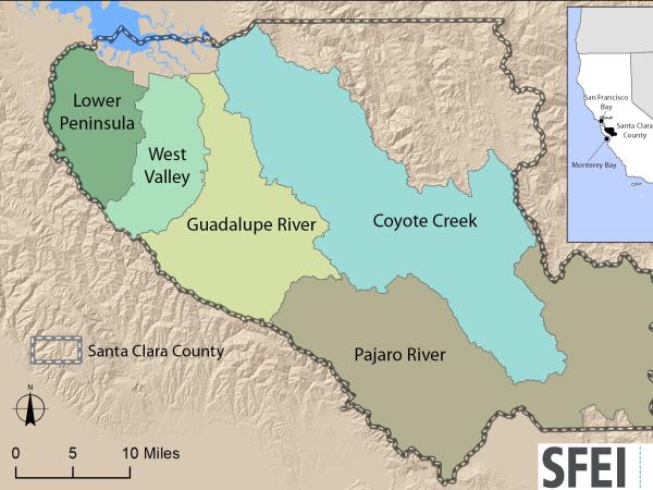 Santa Clara Valley Water District Priority D5 Project's Watershed Condition Assessments (2010 to present) (Project)
https://www.valleywater.org/project-updates/2012-d5-ecological-data-collection-and-analysisSFEI and the Santa Clara Valley Water District's (Valley Water) Priority D-5 Project have been conducting baseline ecological condition assessments in Santa Clara County, CA to characterize the distribution and abundance of stream and wetlands in five major watersheds, and to assess the overall ecological conditions of streams in the watersheds based on the California Rapic Assessment Method for streams (CRAM). The surveys employ the state's recommended Wetland and Riparian Area Monitoring Plan's watershed aproach that includes the use of GIS-base maps of aquatice resources (BAARI), and spatially-balanced ambient stream condition surveys using CRAM.
 Tahoe WRAMP Demonstration: Watershed Assessment (Project)
The Tahoe WRAMP Watershed Demonstration Project transferred statewide wetland monitoring and assessment tools to Sierra Nevada environmental agencies and organizations by conducting a pilot study that evaluated the distribution and abundance of wetlands, and the overall ecological condition of streams in two watersheds within the Lake Tahoe Basin.
 Bay Area Aquatic Resource Inventory (BAARI) (Project)
The Bay Area Aquatic Resources Inventory (BAARI) is a GIS base map of the Bay Area's wetlands, open water, streams, ditches, tidal marshes and flats, and riparian areas. BAARI was developed using standardized mapping protocols to ensure that the level of detail and wetland classification system is standardized across the region.
 Get on the curve: Habitat Development Curves help determine the performance of on-the-ground projects (News)
How do you know if the ecological conditions of your wetland project are aligned with expected rates of improvement?
 Russian River Regional Monitoring Program: Comprehensive Basemap of Surface Waters and Riparian Areas (Project)
This project will build on existing projects funded by the CA State Water Board, Ocean Protection Council, Sonoma Ecology Center, and Sonoma County to produce a basemap of aquatic resources, using the updated Standard Operating Procedures (SOP) of the California Aquatic Resource Inventory (CARI), including at-risk waters and their riparian areas, to support the Russian River Regional Monitoring Program (R3MP). The main tasks of the project are to:
") Vernal Pool Habitat Restoration and Protection CRAM Tools for the Central Valley, CA (Project)
Vernal Pool Habitat Restoration and Protection CRAM Tools for the Central Valley, CA (Project)
The California Wetland Program Plan (WPP) seeks to strengthen protection for wetlands in many ways, including building capacity to track the net benefits of wetland policies and programs by employing aspects of the State’s Wetlands and Riparian Area Monitoring Plan (WRAMP).
 New Delta Habitat Map! (News)
The Delta Aquatic Resource Inventory (DARI) is a map of surface waters, wetlands and other aquatic resources in the Sacramento-San Joaquin Delta. A similar mapping approach used to create the Bay Area Aquatic Resource Inventory (BAARI) was applied to complete a consistent map across the larger San Francisco Estuary. Both DARI and BAARI are integrated into the California Aquatic Resource Inventory (CARI), which serves as the basemap in EcoAtlas.
 10-year Reassessment of Streams in the Coyote Creek Watershed (News)
SFEI and the Santa Clara Valley Water District just completed a report characterizing the amount, diversity, and distribution of aquatic resources in the Coyote Creek watershed, and the overall ecological conditions of streams in the watershed. The 2020 ambient stream condition reassessment survey used a watershed approach and the California Rapid Assessment Method (or CRAM) to compare the amount of stream miles in good, fair, and poor condition among the Hills and Valley regions as well as differences between a 2010 baseline survey and the 2020 reassessment.
 EcoAtlas (Project)
EcoAtlas is a set of tools for generating, assembling, storing, visualizing, sharing, and reporting environmental data and information.
 Russian River Watershed Projects at the San Francisco Estuary Institute (Project)
Our projects in the Russian River Watershed help us to understand our past, understand our present, and envision our future. Learn more about what SFEI is doing in partnership with others to advance our scientific understanding of this valuable landscape.
 Wetlands Regional Monitoring Project (Project)
This Prop 50 - funded project was a three-year effort to monitor and track changes in Bay Area wetland condition. This wetland monitoring toolkit meets basic information needs for managing wetlands: to develop a scientific framework with standard methods for monitoring wetlands and for interpreting the results, and to regularly report the findings to the public. These monitoring tools are intended to help provide a public measure of the environmental costs or benefits of most wetland management actions.
 Coordinated Mapping: How various efforts can work together (News)
SFEI is coordinating the mapping for two inventories of surface waters, wetlands and other aquatic resources in the Sacramento-San Joaquin Delta and along California’s coast. Both efforts will apply the California Aquatic Resource Inventory (CARI) standardized mapping methods and the final map will be integrated into EcoAtlas and made publicly available.
 Coyote Creek Native Ecosystem Enhancement Tool (Project)
The Coyote Creek Native Ecosystem Enhancement Tool (CCNEET, neet. ecoatlas.org) is an online decision-support tool to identify opportunities to improve ecological conditions. CCNEET was inspired by the need for a watershed approach to environmental resource management. Available ecological and environmental information is synthesized by objectives, management questions, and enhancement actions to identify and justify potential habitat improvements along the creek corridor. The overarching goal of CCNEET is to help coordinate habitat conservation and enhancement along so that multiple projects and limited funding can result in meaningful ecological improvement.
- 1 of 3
- next ›