Cristina Grosso

Cristina Grosso, MA
Program Managing Director
Environmental Informatics Program
Data Services
Geographic Information Systems
Software Engineering
Carbon, Ecosystems & Climate
510-746-7371
Cristina Grosso is the Managing Director for SFEI’s Environmental Informatics Program. She earned a B.S. in Mathematics from Vanderbilt University and a M.A. in Geography with an emphasis in Resource Management and Environmental Planning from San Francisco State University. Cristina manages the development of tools for uploading and visualizing data in EcoAtlas, the California Rapid Assessment Method for Wetlands, and the Regional Monitoring Program for Water Quality. She manages the San Francisco Bay-Delta Regional Data Center and works with the State’s other data centers to ensure monitoring data are comparable with the Surface Water Ambient Monitoring Program (SWAMP) and the California Environmental Data Exchange Network (CEDEN).
Related Projects, News, and Events
 Baylands Change Basemap (Project)
The Baylands Change Basemap will update the existing map of tidal marsh, tidal flats and diked baylands to incorporate the many changes in baylands distribution and abundance that have occurred over the last two decades. It will also include new information about land use and infrastructure that affects baylands restoration and management constraints and opportunities. To ensure the map is as up-to-date as possible, the project will develop procedures for ongoing local updates and change detection to cost-effectively maintain the basemap’s high value.
 Enhanced Landscape Profile Modes in EcoAtlas deliver new insights (News)
EcoAtlas is a mapping and geographic data visualization tool that continues to evolve to meet emerging needs. The toolset now includes new data layers and summaries to support the watershed planning, tracking, and reporting needs for the state. Within EcoAtlas, the Landscape Profile Tool provides easy access to summaries and data visualizations on watershed characteristics, ecological condition, habitat connectivity, and coastal habitats for an area of interest.
 EcoAtlas Toolset Training and Outreach Plan (Project)
The California Wetland Monitoring Workgroup’s (CWMW) State Wetland and Riparian Area Monitoring Plan (WRAMP) requires information consistent with EPA’s Level 1‐2‐3 framework for monitoring and assessment of wetland and stream resources.
 California Aquatic Resource Inventory (CARI) (Project)
The California Aquatic Resources Inventory (CARI) is a Geographic Information System (GIS) based map of wetlands, streams, and riparian areas within California that is hosted online through EcoAtlas.
 Delta Aquatic Resource Inventory (Project)
DARI is the Delta Aquatic Resources Inventory of surface waters, wetlands and other aquatic resources in the Sacramento-San Joaquin Delta (Delta). The goal of the DARI project is to develop a geospatial inventory of aquatic resources that will be used as a common base map for the Delta. A similar mapping approach used to create the California Aquatic Resource Inventory (CARI) will be applied to provide a map of the aquatic resources and their associated attributes.
 Preparing for the Storm (Project)
Catalyzed by the extensive damages caused by the Winter 2016-2017 storms and the opportunity to align flood response with major habitat improvement, Preparing for the Storm is an innovative public-private partnership to improve watershed health and resilience in the Alameda Creek watershed.
SFEI will leverage its experience as a Regional Data Center for CEDEN to deliver a scientifically sound data management strategy and plan for the Habematolel Pomo of Upper Lake (HPUL) and the Lake County Watershed Protection District (District).
 California Pesticides: A Data Visualization Tool to Link Pesticide Use and Management to Water Quality (Project)
Despite California's data-rich environment, there are still many obstacles when trying to access and understand pesticide data at the nexus of water quality, ecological effects, and human health. We recognize a need to fill data gaps, not necessarily by collecting new data, but by better leveraging information already technically in the public domain. The goal of this project is to bring pesticide reporting, occurrence, and toxicity data together in ways that yield insights and meet the expressed needs of stakeholders in clear, efficient, credible, and repeatable ways.
 Blue Carbon Science to Support Climate Action (Project)
Working with other scientists, agency staff, and regional and state-level managers and planners, we are building alignment and capacity for blue carbon quantification through science synthesis, outreach, and mapping.
 Landscape Scenario Planning Tool (Project)
This project is a tool for planning scenarios of landscape-scale restoration. The tool is designed to inform ongoing and future restoration planning efforts. In particular, this tool will help inform implementation of restoration objectives as described in the Delta Plan, as well as the ongoing Ecosystem Amendment to Chapter 4.
 Introducing the Landscape Scenario Planning Tool Version 2.0 (News)
In partnership with the Delta Stewardship Council, the San Francisco Estuary Institute has developed version 2.0 of the Landscape Scenario Planning Tool, a GIS-based analysis toolkit to evaluate user-designed land use and restoration scenarios for the Sacramento-San Joaquin Delta and Suisun Marsh. This free mapping toolbox brings together ten years of science-based research and peer-reviewed methods for California’s Delta-Suisun region.
The Regional Watershed Spreadsheet Model (RWSM) was developed to estimate average annual regional and sub-regional scale loads for the San Francisco Bay Area. It is part of a class of deterministic empirical models based on the volume-concentration method.
 Santa Clara Valley Water District Priority D5 Project's Watershed Condition Assessments (2010 to present) (Project)
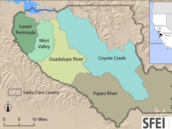
https://www.valleywater.org/project-updates/2012-d5-ecological-data-collection-and-analysisSFEI and the Santa Clara Valley Water District's (Valley Water) Priority D-5 Project have been conducting baseline ecological condition assessments in Santa Clara County, CA to characterize the distribution and abundance of stream and wetlands in five major watersheds, and to assess the overall ecological conditions of streams in the watersheds based on the California Rapic Assessment Method for streams (CRAM). The surveys employ the state's recommended Wetland and Riparian Area Monitoring Plan's watershed aproach that includes the use of GIS-base maps of aquatice resources (BAARI), and spatially-balanced ambient stream condition surveys using CRAM.
 Tahoe WRAMP Demonstration: Watershed Assessment (Project)
The Tahoe WRAMP Watershed Demonstration Project transferred statewide wetland monitoring and assessment tools to Sierra Nevada environmental agencies and organizations by conducting a pilot study that evaluated the distribution and abundance of wetlands, and the overall ecological condition of streams in two watersheds within the Lake Tahoe Basin.
, Dee Shea Himes (R)") Healthy Watersheds Resilient Baylands (Project)
Healthy Watersheds Resilient Baylands (Project)
Through the EPA-funded Healthy Watersheds Resilient Baylands project, SFEI and sixteen partner organizations are developing multi-benefit tools to enhance climate change resilience in San Francisco Bay. Healthy Watersheds Resilient Baylands has two major components: Multi-benefit Urban Greening and Tidal Wetlands Restoration. Through both components, we have developed strategies that inform policy, planning, and design of innovative implementation projects.
 Coastal Wetlands, Beaches and Watersheds Inventory (Project)
The Ocean Protection Council (OPC) and SFEI will develop an inventory of the wetlands and other surface waters of all California’s coastal HUC-8 watersheds, including the inland Delta of the San Francisco Estuary, to help implement the OPC’s 2020-2025 Strategic Plan. The inventory will include a dashboard and other online tools that enable the OPC and the public to track progress towards multiple O
 California Environmental Data Exchange Network (CEDEN) (Project)
The California Environmental Data Exchange Network (CEDEN) is a central location to find and share information about California’s surface waters, including streams, lakes, rivers, and the coastal ocean.
 Get on the curve: Habitat Development Curves help determine the performance of on-the-ground projects (News)
How do you know if the ecological conditions of your wetland project are aligned with expected rates of improvement?
 Russian River Regional Monitoring Program: Comprehensive Basemap of Surface Waters and Riparian Areas (Project)
This project will build on existing projects funded by the CA State Water Board, Ocean Protection Council, Sonoma Ecology Center, and Sonoma County to produce a basemap of aquatic resources, using the updated Standard Operating Procedures (SOP) of the California Aquatic Resource Inventory (CARI), including at-risk waters and their riparian areas, to support the Russian River Regional Monitoring Program (R3MP). The main tasks of the project are to:
") Vernal Pool Habitat Restoration and Protection CRAM Tools for the Central Valley, CA (Project)
Vernal Pool Habitat Restoration and Protection CRAM Tools for the Central Valley, CA (Project)
The California Wetland Program Plan (WPP) seeks to strengthen protection for wetlands in many ways, including building capacity to track the net benefits of wetland policies and programs by employing aspects of the State’s Wetlands and Riparian Area Monitoring Plan (WRAMP).
- 1 of 5
- next ›