San Francisco Estuary Goals Project Area
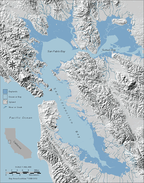
The geographic scope of the San Francisco Wetlands Goals included the portion of the San Francisco Bay-Delta estuary downstream of the Sacramento-San Joaquin Delta. Within this area, the Project designated four primary subregions: Suisun, North Bay, Central Bay, and South Bay.
Each subregion has unique features and presents special opportunities and constraints to habitat enhancement and restoration. These subregions include Suisun, North Bay, Central Bay, and South Bay:
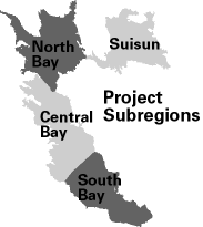
Suisun
The Suisun subregion is furthest upstream in the Project area. It extends from near Chipps Island on the Sacramento River downstream to the Carquinez Bridge. On its northern side is Suisun Marsh, and on its southern side is the Contra Costa shore-line. Its major streams include Green Valley Creek, Sacramento River, Suisun Creek, and Walnut Creek. This subregion lies within Contra Costa and Solano counties. It includes about 75,000 acres of baylands.
North Bay
The North Bay subregion encompasses the baylands and adjacent habitats of San Pablo Bay. Its boundary with the upstreamSuisun subregion is the Carquinez Bridge. Downstream it abuts Central Bay on the western shore at Point San Pedro and on the eastern shore at Point San Pablo. Its larger streams include the Napa River, Sonoma Creek, Petaluma River, Novato Creek, and Gallinas Creek. Lands within this subregion are in Contra Costa, Marin, Napa, Solano, and Sonoma counties. It includes about 80,000 acres of baylands.
Central Bay
The Central Bay subregion includes the main body of San Francisco Bay. It extends along the western shore from Point San Pedro to Coyote Point, and along the eastern shore from Point San Pablo to the San Leandro Marina. Its major streams, all relatively small, include Codornices, Corte Madera, Temescal, and Wildcat creeks. Lands within this subregion are in Alameda, Contra Costa, Marin, San Francisco, and San Mateo counties. It includes about 33,000 acres of baylands.
South Bay
The South Bay subregion includes the southern-most portion of San Francisco Bay. It abuts the Central Bay subregion on the western side at Coyote Point, and on the eastern side at the San Leandro Marina. It has few major streams, and the larger of these include Alameda, Coyote, San Francisquito, San Mateo, and Stevens creeks. It includes lands in Alameda, Santa Clara, and San Mateo counties. It includes about 75,000 acres of baylands.