Martin Trinh
2024. 2021 Update to Copper Rolling Average. SFEI Contribution No. 1164. San Francisco Estuary Institute: Richmond, CA.
2024. 2021 Update to Cyanide Rolling Averages. San Francisco Estuary Institute: Richmond, CA.
2024. 2024 Quality Assurance Program Plan for The Regional Monitoring Program for Water Quality in San Francisco Bay. SFEI Contribution No. 1169. San Francisco Estuary Institute: Richmond, CA.
2024. Development of Semi-Empirical Light Extinction Estimates for Biogeochemical Modeling Applications in San Francisco Bay. SFEI Contribution No. 1177. San Francisco Estuary Institute: Richmond, CA.
2024. Modeling Stormwater Loads of Contaminants of Emerging Concern: Literature Review and Recommendations. SFEI Contribution No. 1131. San Francisco Estuary Institute: Richmond, CA.
2024. Multi Year Plan 2024. SFEI Contribution No. 1167. San Francisco Estuary Institute: Richmond, CA.
The purpose of this document is to guide efforts and summarize plans developed within the RMP. The intended audience includes representatives of the many organizations who directly participate in the Program. This document will also be useful for individuals who are not directly involved with the RMP but are interested in an overview of the Program and where it is heading.
The organization of this Multi-Year Plan parallels the RMP planning process (Figure 2). Section 1 presents the long-term management plans of the agencies responsible for managing water quality in the Bay and the overarching management questions that guide the Program. The agencies’ long-term management plans provide the foundation for RMP planning (Figure 2). In order to turn the plans into effective actions, the RMP distills prioritized lists of management questions that need to be answered (Page 8). The prioritized management questions then serve as a roadmap for scientists on the Technical Review Committee, workgroups, and strategy teams to plan and implement scientific studies to address the most urgent information needs. This information sharpens the focus on management actions that will most effectively and efficiently
2024. Selenium Concentrations in Water and Clams in North San Francisco Bay, 2019-2020. SFEI Contribution No. 1116. San Francisco Estuary Institute: Richmond, CA.
The Regional Monitoring Program for Water Quality in San Francisco Bay (RMP) started implementing a new design for North Bay selenium (Se) sampling in 2019 after a long-term USGS program was terminated in 2017. To determine if the RMP sampling and analysis methods are producing similar results to the USGS study, we compared Se concentrations and stable isotope values in clams at two stations in Suisun Bay, California, that were sampled by the USGS long-term monitoring program from 1995-2010 and the RMP in 2019-2020. We also compared Se concentrations in water (dissolved and particulate) from the RMP Status and Trends sampling in Suisun Bay (1993-2019) to the samples collected as part of this study.
Spatial patterns in clam Se concentrations between the USGS and RMP studies were similar, with lower concentrations at Station 4.1 (Suisun Bay) than at Station 8.1 (Carquinez Strait). Se concentrations at both stations were consistently lower for the RMP samples than those reported in the long-term USGS dataset. Stable isotope values for δ13C and δ15N were similar for the USGS and RMP samples with δ13C and δ15N more enriched at Station 8.1 than 4.1. However, there was not close alignment of the RMP samples to the USGS long-term average, particularly at Station 8.1. Average dissolved Se concentrations in water were consistently lower than the long-term average at Station 4.1 and similar to or above the long-term RMP Status and Trends (S&T) average at Station 8.1. Particulate Se concentrations at Stations 4.1 and 8.1 were nearly one-third of the long-term S&T average in Suisun Bay, likely due to a change in methods for calculating particulate Se.
Additional information is needed to evaluate whether the lower Se concentrations measured in clams as part of the RMP study could be suggestive of declining Se concentrations in North Bay clams between 2010 and 2019 or an artifact of the new analytical lab. Additional data from samples collected by the USGS from 2011-2017 should be examined to fill the gap between the datasets. Continued RMP monitoring will also be valuable in evaluating long-term trends.
2023. 2023 Bay Prey Fish and Near-field / Margins Sediment Sampling and Analysis Plan. SFEI Contribution No. 1141. San Francisco Estuary Institute: Richmond, CA.
This is a sampling and analysis plan for the Bay Status and Trends (S&T) Prey Fish and Near-field / Margins Sediment monitoring for the Regional Monitoring Program for Water Quality in San Francisco Bay (RMP). Bay margins are defined by the RMP as extending from Mean Higher High Water (MHHW) to 1 foot below Mean Lower Low Water (MLLW). These mud flats and adjacent shallow areas of the Bay are productive and highly utilized by biota of interest (humans and wildlife). Near-field stations are located near watershed inputs in the Bay. Prey fish are a key matrix to monitoring the status and impacts of contaminants, especially near margin areas where they have shown strong contamination signals in previous RMP studies. This monitoring design provides a spatially-distributed characterization of contaminant concentrations in fish and sediment found within the margins of Central Bay, South Bay, and Lower South Bay. This study builds on previous S&T efforts to characterize surface sediment contamination across the Bay while piloting routine monitoring of prey fish. Additional samples outside of S&T will be collected for special studies. A subset of samples will be archived for potential future analysis of emerging contaminants or other analyte groups.
2023. 2023 RMP Dry Season Water Cruise Plan. SFEI Contribution No. 1139. San Francisco Estuary Institute: Richmond, CA.
This report details plans associated with the 2023 Regional Monitoring Program for Water Quality in the San Francisco Estuary (RMP) water cruise. The RMP water sampling program was redesigned in 2002 to adopt a randomized sampling design at thirty-one stations in place of the twenty-six base program stations sampled previously. In 2007, the number of stations was decreased to twenty-two stations, and it remains as such for 2023. The analytes for 2023 are based on the Status and Trends (S&T) Review process that started in 2020.
2023. 2023 RMP Sediment Cruise Sampling and Analysis Plan. SFEI Contribution No. 1138. San Francisco Estuary Institute: Richmond, CA.
This report details plans associated with the Regional Monitoring Program for Water Quality in the San Francisco Estuary (RMP) deep bay sediment cruise. The RMP, through the Status and Trends monitoring program, conducts routine monitoring of water, sediment and biological tissue. Deep bay stations (water depth lower than 1 foot below MLLW) have been sampled for the Status and Trends sediment program since its inception. The current monitoring design (reflective of changes made to the Program through the Status and Trends Review process) calls for sampling frequency of deep bay sediment for CECs, PBDEs, and ancillary analytes every five years during the dry season. Every ten years, metals, PAHs, and PCBs will also be sampled. For 2023, sampling operations will entail dry season sample collection at 16 RMP sediment sampling stations for CECs, PBDEs, and ancillary analytes in Central Bay, South Bay, and Lower South Bay.
2023. 2023 RMP Update. SFEI Contribution No. 1148. San Francisco Estuary Institute: Richmond, CA.
The overarching goal of the Regional Monitoring Program for Water Quality in San Francisco Bay (RMP) is to answer the highest priority scientific questions faced by managers of Bay water quality. The RMP is an innovative collaboration between the San Francisco Bay Regional Water Quality Control Board, the regulated discharger community, the San Francisco Estuary Institute, and many other scientists and interested parties. The purpose of this document is to provide a concise overview of recent RMP activities and findings, and a look ahead to significant products anticipated in the next two years. The report includes:
- a brief summary of some of the most noteworthy findings of this multifaceted Program;
- a description of the management context that guides the Program; and
- a summary of progress to date and future plans for addressing priority water quality topics.
2023. 2024 Detailed Workplan and Budget.
In 2024, the Regional Monitoring Program for Water Quality in San Francisco Bay (RMP) is entering its 32nd year of collecting data and communicating information to support water quality management decisions. This Detailed Workplan and Budget describes the activities that will be completed in 2024, the proposed funding levels, and the deliverables for each task.
The planned revenue from RMP fees for 2024 is $4,156k, with additional supplemental fees of $339k from municipal wastewater and $100k from municipal stormwater bringing the total revenue to $4,596k. The expected revenue is $5,216k as shown in Table 1 and Figures 1-2, which is reduced by $200k to account for the lower volume of dredged sediment being disposed of in the Bay, per the Long-Term Management Strategy (LTMS) plan. The $200k figure is a placeholder and the dredger contribution will be updated when we receive the final in-Bay dredge disposal volumes for calendar year 2023 (typically in March of the following year). The majority of the expenses in 2024 (71%) will be for Status and Trends monitoring and special studies (Tasks 6-7). The cost for running the RMP (Tasks 1-5) is $115k higher in 2024 than 2023 and funding allocations have been shifted slightly within each subtask.
2023. Assessment of Long-Chain Polyethoxylate Surfactants in Wastewater Effluent, Stormwater Runoff, and Ambient Water of San Francisco Bay, CA. SFEI Contribution No. 1126. American Chemical Society.
Ethoxylated surfactants are ubiquitous organic environmental contaminants that have received continued attention over the past several decades, particularly as manufacturing rates increase worldwide and as toxicity concerns grow regarding alcohol ethoxylates. Presence of these compounds in surface water has been considered primarily the result of contaminated wastewater effluent by ethoxylated surfactant degradates; as a result, monitoring has focused on the small subset of short-chain ethoxylates in wastewater effluent and receiving waters. This study quantified long-chain alcohol and alkylphenol ethoxylated surfactants in San Francisco Bay area stormwater runoff, wastewater effluent, and ambient Bay water to determine concentrations and inform potential pathways of contamination. We employed high-performance liquid chromatography coupled to high-resolution mass spectrometry to quantitate long-chain polyethoxylates, which are rarely monitored in ethoxylated surfactant studies. Similar total ethoxylated surfactant concentrations were observed in stormwater runoff (0.004–4.7 μg/L) and wastewater effluent (0.003–4.8 μg/L, outlier of 45 μg/L). Ambient Bay water contamination (0.0001–0.71 μg/L) was likely the result of both stormwater and wastewater inputs to San Francisco Bay. These results suggest that a broader focus including long-chain compounds and stormwater pathways may be needed to fully characterize the occurrence and impacts of ethoxylated surfactants in urban surface waters.
2023. Bathymetric change analysis in San Francisco Bay, California, from 1971 to 2020. United States Geological Survey Pacific Coastal and Marine Science Center: Santa Cruz, CA.
This data release provides bathymetric change grids of four geographic areas of San Francisco Bay, California, comparing digital elevation models (DEMs) created from bathymetric data collected in the 1970s and 1980s with DEMs created from bathymetric data collected in the 2010s and 2020. These types of change analyses can provide information on the quantities and patterns of erosion and deposition in San Francisco Bay over the 9 to 47 years between surveys, and they reveals that the bay floor lost about 34 million cubic meters of sediment between the intervening time period. Results from this study can be used to assess how San Francisco Bay has responded to changes in the system such as sea-level rise and variation in sediment supply from the Sacramento-San Joaquin Delta and local tributaries, and supports the creation of a new, system-wide sediment budget. These bathymetric change grids can also provide data to ecosystem managers about the quantities and patterns of sediment volume change in San Francisco Bay to assist in decision-making for a variety of sediment-related issues, including restoration of tidal marshes, exposure of legacy contaminated sediment, and strategies for the beneficial use of dredged sediment.
2023. Bathymetric change analysis in San Francisco Bay, California, from 1971 to 2020. United States Geological Survey.
This data release provides bathymetric change grids of four geographic areas of San Francisco Bay, California, comparing digital elevation models (DEMs) created from bathymetric data collected in the 1970s and 1980s with DEMs created from bathymetric data collected in the 2010s and 2020. These types of change analyses can provide information on the quantities and patterns of erosion and deposition in San Francisco Bay over the 9 to 47 years between surveys, and they reveals that the bay floor lost about 34 million cubic meters of sediment between the intervening time period. Results from this study can be used to assess how San Francisco Bay has responded to changes in the system such as sea-level rise and variation in sediment supply from the Sacramento-San Joaquin Delta and local tributaries, and supports the creation of a new, system-wide sediment budget. These bathymetric change grids can also provide data to ecosystem managers about the quantities and patterns of sediment volume change in San Francisco Bay to assist in decision-making for a variety of sediment-related issues, including restoration of tidal marshes, exposure of legacy contaminated sediment, and strategies for the beneficial use of dredged sediment.
2023. Grain size, bulk density, and carbon content of sediment collected from Whale's Tail South marsh and adjacent bay floor, South San Francisco Bay, California, 2021-2022. U.S. Geological Survey.
Sediment samples were collected on and adjacent to the Whale’s Tail South marsh. Short push-cores of bed sediment were collected in South San Francisco Bay adjacent to Whales Tail South marsh on five days from June through August 2021 and 3 days from November 2021 to January 2022. Additional samples were taken from ceramic tiles placed on the marsh to measure sediment deposition and from rip-up clasts deposited on the marsh edge. Samples were analyzed for sediment properties including bulk density, particle size distribution, and percent carbon. These data were collected as part of a collaborative study with the USGS Western Ecological Research Center to quantify sediment fluxes, deposition on the marsh, and changes in marsh morphology at Whale's Tail marsh in southern San Francisco Bay.
2023. Hydrodynamic and sediment transport data from Whale's Tail marsh and adjacent waters in South San Francisco Bay, California 2021-2022. United States Geological Survey.
The U.S. Geological Survey Pacific Coastal and Marine Science Center collected hydrodynamic and sediment-transport data at shallow water sites in South San Francisco Bay and in the Whale's Tail South marsh in Eden Landing Ecological Reserve in Alameda County, CA in 2021 and 2022. This data release includes hydrodynamic and sediment transport time-series data spanning from June 2021 to January 2022, as well as sediment bed properties and water column suspended-sediment concentrations Details on station location, instrumentation, and measured variables are included in sections for each data type. The data were collected to determine sediment supply and sediment delivery to marshes, both in the bay and in tidal creeks as well as across the bay-marsh interface during varying tidal and wave conditions. The goal of the project was to more accurately predict the fate of marshes and to optimize management actions. They were collected as part of a collaborative study with the USGS Western Ecological Research Center. These data are intended for science researchers, students, policy makers, and the general public.
2023. Multi-Year Plan 2023. SFEI Contribution No. 1096. San Francisco Estuary Institute: Richmond, California.
The purpose of this document is to guide efforts and summarize plans developed within the RMP. The intended audience includes representatives of the many organizations who directly participate in the Program. This document will also be useful for individuals who are not directly involved with the RMP but are interested in an overview of the Program and where it is heading.
The organization of this Multi-Year Plan parallels the RMP planning process (Figure 2). Section 1 presents the long-term management plans of the agencies responsible for managing water quality in the Bay and the overarching management questions that guide the Program. The agencies’ long-term management plans provide the foundation for RMP planning (Figure 2). In order to turn the plans into effective actions, the RMP distills prioritized lists of management questions that need to be answered (Page 8). The prioritized management questions then serve as a roadmap for scientists on the Technical Review Committee, workgroups, and strategy teams to plan and implement scientific studies to address the most urgent information needs. This information sharpens the focus on management actions that will most effectively and efficiently improve water quality in the Bay.
2023. North Bay Selenium 2019-20 QA Summaries. San Francisco Estuary Institute: Richmond, CA.
2023. Re-evaluation of the Floating Percentile Method for Deriving Dredged Sediment Screening Guidelines. SFEI Contribution No. 1143. San Francisco Estuary Institute: Richmond, California.
This document summarizes a study conducted for the Regional Monitoring Program for Water Quality in San Francisco Bay (RMP) to re-evaluate the use of the Floating Percentile Method
(FPM) to derive sediment screening guidelines for dredged material reuse in the San Francisco Bay Region. The Long Term Management Strategy (LTMS) has a goal to use at least 40% of the sediment dredged from San Francisco Bay for beneficial reuse (USACE, 1998). The suitability of dredged sediment for beneficial reuse is in part determined by concentrations of toxic pollutants.The San Francisco Regional Water Quality Control Board (SFB-RWQCB) issued draft screening criteria in 2000 to categorize the suitability of sediment for reuse as either “surface” sediment, that may be placed near the surface for re-use in wetlands, or “foundation” sediment, that is buried under sediment that meets surface criteria. Contaminant concentration guidelines for surface sediment are lower than foundation sediment, based on the assumption that biota are more likely to be exposed to surface sediment than deeper foundation sediment.
2023. San Francisco Bay Sediment Modeling and Monitoring Workplan. SFEI Contribution No. 1100. San Francisco Estuary Institute: Richmond, CA.
This document was prepared with guidance gained through two RMP Sediment Workgroup workshops held in late 2022 and early 2023. Given the variety of participants involved, this Workplan encompasses interests beyond San Francisco Bay RMP funders. We thank the attendees for their contributions.
In 2020, the Sediment Workgroup (SedWG) of the Regional Monitoring Program for Water Quality in San Francisco Bay (RMP) completed a Sediment Monitoring and Modeling Strategy (SMMS) which laid out a conceptual level series of data and information gaps and generally recommended the use of both empirical data collection and modeling tools to answer initial high priority management questions (McKee et al., 2020). At the time, the SMMS promoted the use of surrogates such as time-continuous turbidity measurements for cross-section flux modeling within the Bay without an understanding of existing Bay hydrodynamic models, their strengths, weaknesses, and potential uses for understanding coupled Bay-mudflat-marsh processes. Since then, the Wetland Regional Monitoring Program (WRMP, www.wrmp.org) has generally promoted the use of coupling monitoring and modeling techniques to inform wetlands sediment management decisions. In addition, he completion of the Sediment for Survival report (a RMPEPA funded collaboration) and the further development of sediment conceptual models has also advanced the need for a coupled dynamic modeling and monitoring program that has the capacity to explore more complex management questions (Dusterhoff et al., 2021; SFEI, 2023). Such a program will take time to develop, but will be more cost-efficient and adaptable and allow for more timely answers to pressing questions.
2023. Sediment Deposition and Accretion Data from a Tidal Salt Marsh in South San Francisco Bay, California 2021-2022. U.S. Geological Survey Western Ecological Research Center .
The U.S. Geological Survey, Western Ecological Research Center collected sediment and accretion data at a wave-exposed tidal salt marsh in South San Francisco Bay, California. Sediment traps and feldspar marker horizons (MH) were deployed along transects of increasing distance from the sediment source, at primary, secondary and tertiary marsh channels/bay. Data were collected bi-monthly over two month periods in summer 2021 and winter 2021/2022. Included here are trap and MH plot locations, calculated sediment fluxes at each station by deployment period, annual accretion rates, and covariates associated with sediment deposition and accretion including vegetation structure and elevation. This project aimed to assess the temporal and spatial patterns in sediment deposition in order to better understand sediment delivery and marsh resilience to sea-level rise.
2023. Sediment deposition, erosion, and bathymetric change in San Francisco Bay, California, 1971–1990 and 1999–2020. United States Geological Survey Pacific Coastal and Marine Science Center: Santa Cruz, CA.
Bathymetric change analyses document historical patterns of sediment deposition and erosion, providing valuable insight into the sediment dynamics of coastal systems, including pathways of sediment and sediment-bound contaminants. In 2014 and 2015, the Office for Coastal Management, in partnership with the National Oceanic and Atmospheric Administration (NOAA) Office of Coastal Management, provided funding for new bathymetric surveys of large portions of San Francisco Bay. A total of 93 bathymetric surveys were conducted during this 2-year period, using a combination of interferometric sidescan and multibeam sonar systems. These data, along with recent NOAA, U.S. Geological Survey (USGS), U.S. Army Corps of Engineers, and private contractor surveys collected from 1999 to 2020 (hereinafter referred to as 2010s), were used to create the most comprehensive bathymetric digital elevation models (DEMs) of San Francisco Bay since the 1980s. Comparing DEMs created from these 2010s surveys with USGS DEMs created from NOAA’s 1971–1990 (hereinafter referred to as 1980s) surveys provides information on the quantities and patterns of erosion and deposition in San Francisco Bay during the 9 to 47 years between surveys. This analysis reveals that in the areas surveyed in both the 1980s and 2010s, the bay floor lost about 34 million cubic meters of sediment since the 1980s. Results from this study can be used to assess how San Francisco Bay has responded to changes in the system, such as sea-level rise and variation in sediment supply from the Sacramento-San Joaquin Delta and local tributaries, and supports the creation of a new, system-wide sediment budget. This report provides data on the quantities and patterns of sediment volume change in San Francisco Bay for ecosystem managers that are pertinent to various sediment-related issues, including restoration of tidal marshes, exposure of legacy contaminated sediment, and strategies for the beneficial use of dredged sediment.
2023. Sediment Deposition, Erosion, and Bathymetric Change in San Francisco Bay, California, 1971–1990 and 1999–2020. United State Geological Survey: Santa Cruz, CA.
Bathymetric change analyses document historical patterns of sediment deposition and erosion, providing valuable insight into the sediment dynamics of coastal systems, including pathways of sediment and sediment-bound contaminants. In 2014 and 2015, the California Ocean Protection Council, in partnership with the National Oceanic and Atmospheric Administration (NOAA) Office of Coastal Management, provided funding for new bathymetric surveys of large portions of San Francisco Bay. A total of 93 bathymetric surveys were conducted during this 2-year period, using a combination of interferometric sidescan and multibeam sonar systems. These data, along with recent NOAA, U.S. Geological Survey (USGS), U.S. Army Corps of Engineers, and private contractor surveys collected from 1999 to 2020 (hereinafter referred to as 2010s), were used to create the most comprehensive bathymetric digital elevation models (DEMs) of San Francisco Bay since the 1980s. Comparing DEMs created from these 2010s surveys with USGS DEMs created from NOAA’s 1971–1990 (hereinafter referred to as 1980s) surveys provides information on the quantities and patterns of erosion and deposition in San Francisco Bay during the 9 to 47 years between surveys. This analysis reveals that in the areas surveyed in both the 1980s and 2010s, the bay floor lost about 34 million cubic meters of sediment since the 1980s. Results from this study can be used to assess how San Francisco Bay has responded to changes in the system, such as sea-level rise and variation in sediment supply from the Sacramento-San Joaquin Delta and local tributaries, and supports the creation of a new, system-wide sediment budget. This report provides data on the quantities and patterns of sediment volume change in San Francisco Bay for ecosystem managers that are pertinent to various sediment-related issues, including restoration of tidal marshes, exposure of legacy contaminated sediment, and strategies for the beneficial use of dredged sediment.
2023. Structure-from-motion derived orthomosaic imagery and digital surface models (DSMs) from the intertidal region at Whale's Tail Marsh, South San Francisco Bay, CA. United States Geological Survey: South San Francisco Bay, CA.
This data release presents digital surface models (DSMs) and orthomosaic images of the Whale's Tail Marsh region of South San Francisco Bay, CA. The data were created using structure-from-motion (SfM) processing of repeat aerial imagery collected from fixed-wing aircraft. The raw images were acquired from an approximate altitude of 427 meters (1,400 feet) above ground level (AGL), using a Hasselblad A6D-100c camera fitted with an HC 80 lens, resulting in a nominal ground-sample-distance (GSD) of 2.5 centimeters per pixel. The acquisition flight lines were designed to provide approximately 50 percent overlap between adjacent flight lines (sidelap), with approximately 70 percent overlap between sequential images along the flight line (forelap). Survey control was established using an onboard camera-synchronized dual-frequency GPS system as well as ground control points (GCPs) distributed throughout the survey area and measured using survey-grade post-processed kinematic (PPK) GPS. Both the data from the onboard GPS and from the GPS used to measure the GCPs were post-processed using a nearby Continuously Operating Reference Station (CORS) operated by the National Geodetic Survey (NGS). Structure-from-motion processing of these data was conducted using a "4D" processing workflow in which imagery from each of the different acquisition dates were co-aligned to increase relative spatial precision between the final data products.
2023. Water Year 2023 RMP Near-Field Water Sampling and Analysis Plan. SFEI Contribution No. 1142. San Francisco Estuary Institute: Richmond, CA.
This report details plans associated with the pilot near-field water sampling for the Regional Monitoring Program for Water Quality in San Francisco Bay (RMP). The RMP recently reviewed the Status & Trends (S&T) Program and added a pilot effort to quantify contaminants of emerging concern (CECs) in Bay water in areas near (“near-field” of) expected loading pathways during or shortly after storm events and during the dry season. For the first year of the pilot (Water Year 2022), the near-field design included three targeted, near-field stations and four ambient Bay stations. Subsequent years added a fourth near-field station. Samples will be collected at these stations during or shortly after two storm events, and once in the dry season. The analytes that are being measured include bisphenols, organophosphate esters (OPEs), PFAS, and a suite of stormwater CECs.
. 2022. 2021 RMP Water Cruise Report. SFEI Contribution No. 1098. Applied Marine Sciences: Livermore, CA.
This report details activities associated with the biannual Regional Monitoring Program for Water Quality in the San Francisco Estuary (RMP) water cruise. The RMP water sampling program was redesigned in 2002 to adopt a randomized sampling design at thirty-one sites in place of the twenty-six “spine of the Estuary” stations sampled previously. In 2007, the number of sites was decreased to twenty-two stations, combined probabilistic and historic, and it remains as such for 2021.
2022. 2022 Pulse of the Bay. SFEI Contribution No. 1095. San Francisco Estuary Institute: Richmond, California.
 The theme of the 2022 Pulse is "50 Years After the Clean Water Act." Nine different individuals or groups have contributed perspectives on progress to date and challenges ahead. This Pulse also includes summaries, from a historical perspective, on the major water quality parameters of concern in the Bay.
2022. 2022 Pulse Resources.
2022. 2022 RMP Multi-Year Plan. SFEI Contribution No. 1058. San Francisco Estuary Institute: Richmond, California.
2022. 2023 Detailed Workplan and Budget. SFEI Contribution No. 1117. San Francisco Estuary Institute: Richmond, California.
2022. Charter: Regional Monitoring Program for Water Quality in San Francisco Bay. SFEI Contribution No. 1184. San Francisco Estuary Institute: Richmond, CA.
This Charter describes the purpose and function of the Regional Monitoring Program for Water
Quality in San Francisco Bay (RMP). Established in 1993, the RMP is a collaborative effort
between the San Francisco Estuary Institute, the California Regional Water Quality Control
Board, San Francisco Bay Region, and the regulated discharger community.
2022. Microplastics from Tire Particles in San Francisco Bay Factsheet. SFEI Contribution No. 1074. San Francisco Estuary Institute: Richmond, CA.
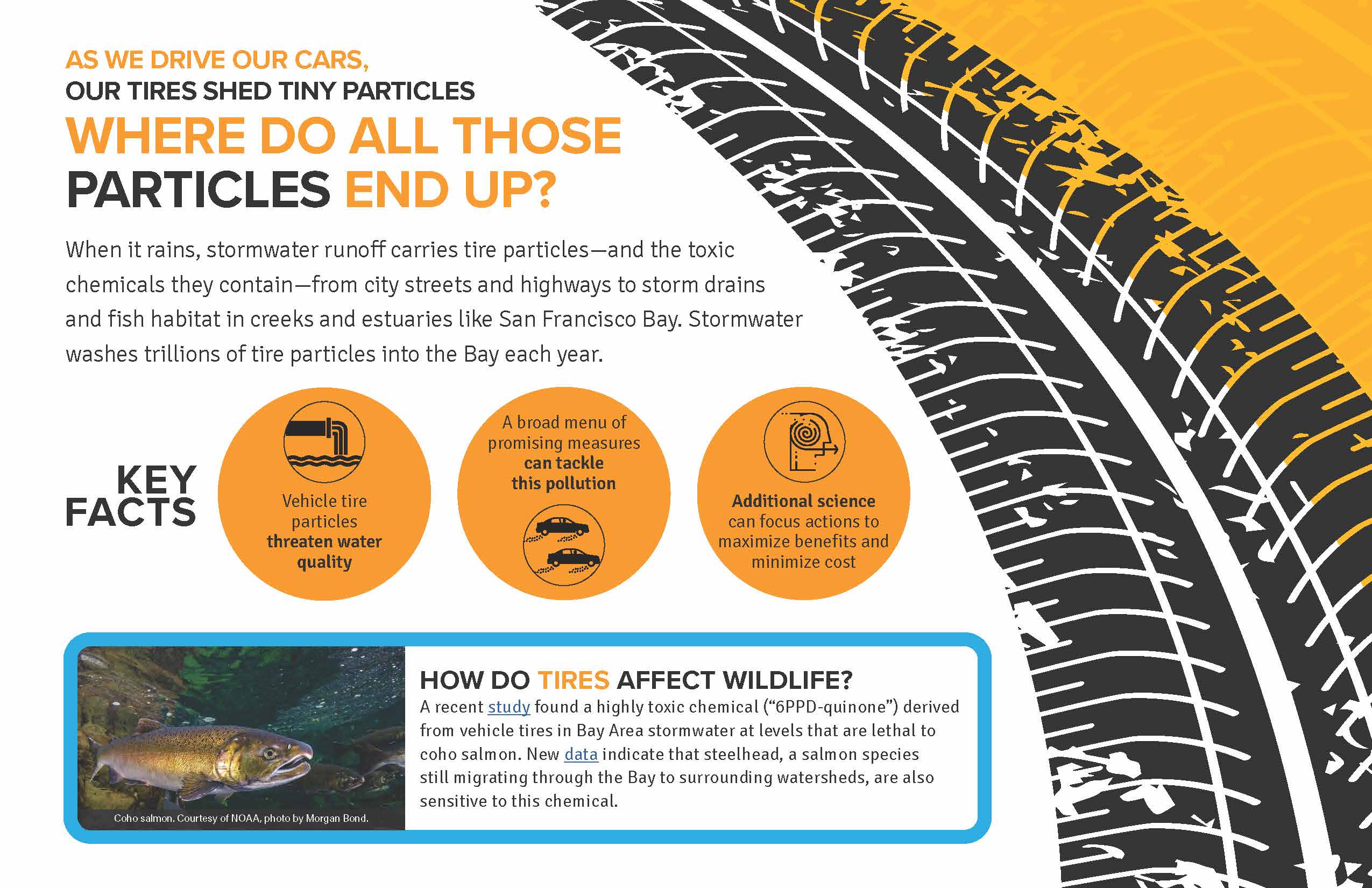 As we drive our cars, our tires shed tiny particles
When it rains, stormwater runoff carries tire particles—and the toxic chemicals they contain—from city streets and highways to storm drains and fish habitat in creeks and estuaries like San Francisco Bay. Stormwater washes trillions of tire particles into the Bay each year.
How do tires affect wildlife?
A recent study found a highly toxic chemical (“6PPD-quinone”) derived from vehicle tires in Bay Area stormwater at levels that are lethal to coho salmon. New data indicate that steelhead, a salmon species still migrating through the Bay to surrounding watersheds, are also sensitive to this chemical.
2022. Occurrence and risk assessment of organophosphate esters and bisphenols in San Francisco Bay, California, USA. Science of the Total Environment 813 . SFEI Contribution No. 982.
Organophosphate esters (OPEs) and bisphenols are two classes of industrial chemicals that are ubiquitously detected in environmental matrices due to high global production and widespread use, particularly in the manufacture of plastic products. In 2017, water samples collected throughout the highly urbanized San Francisco Bay were analyzed for 22 OPEs and 16 bisphenols using liquid chromatography-electrospray ionization-Q Trap-mass spectrometry. Fifteen of the 22 OPEs were detected, with highest median concentrations in the order TCPP (42 ng/L) > TPhP (9.5 ng/L) > TBOEP (7.6 ng/L) > TnBP (7.5 ng/L) > TEP (6.7 ng/L) > TDCIPP (6.2 ng/L). In contrast, only two of 16 bisphenols, BPA and BPS, were quantified, with concentrations ranging from <0.7–35 ng/L and <1–120 ng/L, respectively. BPA and a few OPEs (EHDPP and TEHP) were primarily present in the particulate phase, while BPS and all other observed OPEs were predominantly found in the dissolved phase. Pairwise correlation analysis revealed several strong, positive correlations among OPEs, and few weak, negative correlations between OPEs and BPA, suggesting differences between the two classes with respect to their sources, pathways, and/or fate in the environment. Concentrations of OPEs and bisphenols observed in this study were generally consistent with reported concentrations in other estuarine and marine settings globally. TDCIPP exceeded existing predicted no-effect concentrations (PNECs) at some sites, and six other compounds (TCrP, IDDPP, EHDPP, TPhP, TBOEP, and BPA) were observed at levels approaching individual compound PNECs (not considering mixture effects), indicating potential risks to Bay biota. These results emphasize the need to control releases of these contaminants in order to protect the ecosystem. Periodic monitoring can be used to maintain vigilance in the face of potential regrettable substitutions.
2022. Priority margin unit stormwater monitoring to support load estimates of PCBs into San Leandro Bay and the Emeryville Crescent. SFEI Contribution No. 1088. San Francisco Estuary Institute: Richmond, CA.
2022. San Francisco Bay Watershed Dynamic Model (WDM) Progress Report, Phase 2. SFEI Contribution No. 1091. San Francisco Estuary Institute: Richmond, California.
The San Francisco Bay total maximum daily loads (TMDLs) call for a 50% reduction in mercury (Hg) loads by 2028 and a 90% reduction in PCBs loads by 2030. In support of these TMDLs, the Municipal Regional Permit for Stormwater (MRP) (SFBRWQCB, 2009, SFBRWQCB, 2015, SFBRWQCB, 2022) called for the implementation of control measures to reduce PCBs and Hg loads from urbanized tributaries. In addition, the MRP has identified additional information needs associated with improving understanding of sources, pathways, loads, trends, and management opportunities of pollutants of concern (POCs). In response to the MRP requirements and information needs, the Small Tributary Loading Strategy (STLS) was developed, which outlined a set of management questions (MQs) that have been used as the
guiding principles for the region’s stormwater-related activities. In recognition of the need to evaluate changes in loads or concentrations of POCs from small tributaries on a decadal scale, the updated 2018 STLS Trends Strategy (Wu et al., 2018) prioritized the development of a new dynamic regional watershed model for POCs (PCBs and Hg focused) loads and trends. This regional modeling effort will provide updated estimates of POC concentrations and loads for all local watersheds that drain to the Bay. The Watershed Dynamic Model (WDM) will also provide
a mechanism for evaluating the impact of management actions on future trends of POC loads or concentrations.
As a multi-use modeling platform, the WDM is being developed to include other pollutants, such as contaminants of emerging concern (CECs), sediment, and nutrients and to be coupled with a Bay fate model to form an integrated watershed-Bay modeling framework to address Regional Monitoring Program (RMP) management questions. As this model is developed, flexibility to link with other models will be an important consideration.
2022. Small Tributaries Pollutants of Concern Reconnaissance Monitoring: Application of Storm-event Loads and Yields-Based and Congener-Based PCB Site Prioritization Methodologies. SFEI Contribution No. 1067.
Stormwater agencies in the San Francisco Bay Area are identifying watershed areas that are polluted with PCBs in order to prioritize management efforts to reduce impairment in the Bay caused by PCBs carried in stormwater. Water sampling during storms has been used to characterize PCB concentrations but management prioritization based on the comparison of concentrations between watersheds is made difficult due to variations in flow and sediment erosion between storms and in relation to varying land use. In addition, identifying PCB source areas within priority watersheds has proven complex and costly. To address these challenges, the San Francisco Bay Regional Monitoring Program (RMP) has developed two new interpretive methods based on storm-event PCB yields (PCBs mass per unit area per unit time) and fingerprints of Aroclors (commercial PCB mixtures) that make existing data more useful for decision-making.
The objectives of this study were to:
- Apply the yield method to the regional stormwater dataset and provide new rankings,
- Estimate the presence of Aroclors in samples where congener data are available
- Evaluate data weaknesses and recommend watersheds to resample, and
- Classify watersheds into high, medium, and low categories for potential management.
2022. Strategy for In-Bay Fate Modeling to Support Contaminant and Sediment Management in San Francisco Bay. SFEI Contribution No. 1090. San Francisco Estuary Institute: Richmond, California.
This report presents a strategy and multi-year workplan for modeling polychlorinated biphenyls (PCBs), contaminants of emerging concern (CECs), and sediment in San Francisco Bay (the Bay). Robust in-Bay fate modeling is needed to address priority management questions that have been identified for these constituents.
The strategy for in-Bay modeling presented in this report is a major element of a broader, integrated strategy that is being developed across RMP Workgroups for modeling contaminants flowing from the Bay watersheds and other pathways into the Bay. The broader project is expected to yield an integrated strategy in 2022, followed by implementation of a pilot effort in 2023. Coordination of the in-Bay modeling effort with the broader integrated strategy and other modeling work (e.g., nutrient modeling under the Nutrient Management Strategy) will be critical to optimizing use of the funds allocated to modeling.
2022. Summary and Evaluation of Bioaccumulation Tests for Total Polychlorinated Biphenyls (PCBs) Conducted by San Francisco Bay Dredging Projects. SFEI Contribution No. 1092. San Francisco Estuary Institute: Richmond, California.
The Dredged Material Management Office (DMMO) is responsible for annually approving dredging and disposal of millions of cubic yards of sediment to maintain safe navigation in San Francisco Bay. Dredged sediment is characterized for physical, chemical, and biological characteristics to ensure sediment disposed of in the Bay or at beneficial use locations does not cause adverse environmental impacts. Bioaccumulation thresholds and total maximum daily loads (TMDLs) have been established for several contaminant classes, including PCBs, and are used by the DMMO to determine whether sediment contaminant levels trigger subsequent bioaccumulation testing. Sediment with contaminant concentrations above any TMDL levels cannot be disposed of within the Bay but may be further evaluated for upland reuse and ocean disposal. The objective of this study was to evaluate PCB bioaccumulation data from navigational dredging projects to assess the existence of correlations between sediment chemistry and bioaccumulation test results. The motivation for this study was to determine whether the current PCB bioaccumulation trigger is effective in differentiating sediment bioaccumulation concerns. The DMMO may use the results of this study to inform evaluation requirements for PCBs, particularly in support of modifying the terms of the Long-term Management Strategy for San Francisco Bay (LTMS) programmatic Essential Fish Habitat (EFH) agreement concerning PCB bioaccumulation testing.
2022. Suspect Screening and Chemical Profile Analysis of Storm-Water Runoff Following 2017 Wildfires in Northern California. Environmental Toxicology and Chemistry . SFEI Contribution No. 1089.
The combustion of structures and household materials as well as firefighting during wildfires lead to releases of potentially hazardous chemicals directly into the landscape. Subsequent storm-water runoff events can transport wildfire-related contaminants to downstream receiving waters, where they may pose water quality concerns. To evaluate the environmental hazards of northern California fires on the types of contaminants in storm water discharging to San Francisco Bay and the coastal marine environment, we analyzed storm water collected after the northern California wildfires (October 2017) using a nontargeted analytical (NTA) approach. Liquid chromatography quadrupole time-of-flight mass spectrometric analysis was completed on storm-water samples (n = 20) collected from Napa County (impacted by the Atlas and Nuns fires), the city of Santa Rosa, and Sonoma County (Nuns and Tubbs fires) during storm events that occurred in November 2017 and January 2018. The NTA approach enabled us to establish profiles of contaminants based on peak intensities and chemical categories found in the storm-water samples and to prioritize significant chemicals within these profiles possibly attributed to the wildfire. The results demonstrated the presence of a wide range of contaminants in the storm water, including surfactants, per- and polyfluoroalkyl substances, and chemicals from consumer and personal care products. Homologs of polyethylene glycol were found to be the major contributor to the contaminants, followed by other widely used surfactants. Nonylphenol ethoxylates, typically used as surfactants, were detected and were much higher in samples collected after Storm Event 1 relative to Storm Event 2. The present study provides a comprehensive approach for examining wildfire-impacted storm-water contamination of related contaminants, of which we found many with potential ecological risk. Environ Toxicol Chem 2022;00:1–14. © 2022 SETAC
2021. 2019 RMP Data Quality Assurance Report. San Francisco Estuary Institute: Richmond, CA.
This memo provides a high-level summary of the quality assurance assessment for data reported by the RMP. In 2019, fish tissue samples were collected from nine Bay/Delta areas and three additional wetland/slough areas for the Regional Monitoring Program for Water Quality in San Francisco Bay (RMP). General descriptions of the sample collection methods are provided in the RMP Quality Assurance Program Plan, cruise plans, cruise reports, and field sampling reports. These documents are available from the SFEI website (http://www.sfei.org/content/status-and-trends-monitoring-documents).
2021. 2020-21 RMP North Bay Selenium Study. SFEI Contribution No. 1052. San Francisco Estuary Institute: Richmond, CA.
This report details activities associated with the Regional Monitoring Program North Bay Selenium Study in 2020 and 2021. The study was designed to monitor two sites for selenium (Se) in water and clam tissue six times annually between June and February. Due to the COVID pandemic, however, four sample collection events were completed. This report outlines the sampling activities, personnel, and site locations monitored for the project.
2021. 2020 Bay Margins Sediment Study Cruise Plan. SFEI Contribution No. 1073. San Francisco Estuary Institute: Richmond, California.
This report details plans associated with sediment sampling for the Bay Margins Sediment Study for the Regional Monitoring Program for Water Quality in San Francisco Bay (RMP). Bay margins (i.e., mud flats and adjacent shallow areas of the Bay) are productive and highly utilized by biota of interest (humans and wildlife). This study will provide a spatially-distributed characterization of surface sediment contamination and ancillary characteristics within San Pablo Bay, Suisun Bay, and Carquinez Strait margin areas. This study builds on two previous studies to characterize surface sediment contamination in Central and South Bays.
2021. 2021 Quality Assurance Program Plan for the Regional Monitoring Program for Water Quality in San Francisco Bay. SFEI Contribution No. 1048. San Francisco Estuary Institute: Richmond, California.
2021. 2021 RMP Detailed Workplan and Budget. SFEI Contribution No. 1182. San Francisco Estuary Institute: Richmond, CA.
In 2021 the Regional Monitoring Program for Water Quality in San Francisco Bay (RMP) is entering its 29th year of collecting data and communicating information to support water quality management decisions. This Detailed Workplan and Budget describes the activities that will be completed in 2021, the proposed funding levels, and the deliverables for each task.
2021. 2021 RMP Water Cruise Plan. SFEI Contribution No. 1050. San Francisco Estuary Institute: Richmond, California.
This report details plans associated with the annual Regional Monitoring Program for Water Quality in the San Francisco Estuary (RMP) water cruise. The RMP water sampling program was redesigned in 2002 to adopt a randomized sampling design at thirty-one sites in place of the twenty-six base program stations sampled previously. In 2007, the number of sites was decreased to twenty-two stations, and it remains as such for 2021. The analytes for 2021 have been modified based on the Status and Trends (S&T) Review process that started in 2020. The analytes that are being removed from the program include selenium and methylmercury (dissolved and particulate), while bisphenols and organophosphate esters (OPEs) have been added to S&T monitoring.
2021. Assessment of emerging polar organic pollutants linked to contaminant pathways within an urban estuary using non-targeted analysis. SFEI Contribution No. 1107. Environmental Sciences: Processes and Impacts.
A comprehensive, non-targeted analysis of polar organic pollutants using high resolution/accurate mass (HR/AM) mass spectrometry approaches has been applied to water samples from San Francisco (SF) Bay, a major urban estuary on the western coast of the United States, to assess occurrence of emerging contaminants and inform future monitoring and management activities. Polar Organic Chemical Integrative Samplers (POCIS) were deployed selectively to evaluate the influence of three contaminant pathways: urban stormwater runoff (San Leandro Bay), wastewater effluent (Coyote Creek, Lower South Bay), and agricultural runoff (Napa River). Grab samples were collected before and after deployment of the passive samplers to provide a quantitative snapshot of contaminants for comparison. Composite samples of wastewater effluent (24 hours) were also collected from several wastewater dischargers. Samples were analyzed using liquid-chromatography coupled to high resolution mass spectrometry. Resulting data were analyzed using a customized workflow designed for high-fidelity detection, prioritization, identification, and semi-quantitation of detected molecular features. Approximately 6350 compounds were detected in the combined data set, with 424 of those compounds tentatively identified through high quality spectral library match scores. Compounds identified included ethoxylated surfactants, pesticide and pharmaceutical transformation products, polymer additives, and rubber vulcanization agents. Compounds identified in samples were reflective of the apparent sources and pathways of organic pollutant inputs, with stormwater-influenced samples dominated by additive chemicals likely derived from plastics and vehicle tires, as well as ethoxylated surfactants.
2021. Hydrodynamic, sediment transport, and sediment flocculation data from south San Francisco Bay, California, summer 2020. United Sates Geological Survey.
The U.S. Geological Survey (USGS) Pacific Coastal and Marine Science Center collected hydrodynamic and suspended sediment flocculation data at channel and shallow water sites in south San Francisco Bay in July 2020. The data were used to determine water column stratification, turbulence profiles, and floc size evolution. The goal of this project was to bound the controls on floc size and floc settling velocity to improve estimates of sediment fluxes and consider error in numerical models of sediment transport in San Francisco Bay. This data release includes hydrodynamic, sediment concentration, and particle size timeseries during July 2020, as well as sediment bed properties, water column particle size distributions, and CTD profiles collected on four days in July 2020 at both sites. Details on station location, instrumentation, and measured variables are included on pages for each data type. These data were collected as part of a collaborative project with the USGS California Water Science Center. Funding was provided by the San Francisco Estuary Institute.
2021. PCBs in Shiner Surfperch in Priority Margin Areas of San Francisco Bay. SFEI Contribution No. 1054.
Conceptual models developed for selected San Francisco Bay margin areas (referred to as priority margin units, or PMUs) have identified shiner surfperch as a crucial indicator of PCB impairment, due to their explicit inclusion as an indicator species in the PCBs TMDL, importance as a popular sport fish species, tendency to accumulate high PCB concentrations, site fidelity, and other factors. The conceptual models recommend periodic monitoring of shiner surfperch to track trends in the PMUs, and as the ultimate indicator of progress in reduction of impairment. The objectives of this study were to 1) establish baselines for long-term monitoring of PCB concentrations in shiner surfperch in four PMUs, and 2) understand local spatial variation in shiner PCB concentrations to support optimization of the long-term sampling design. This study also provided valuable information on the presence of shiner surfperch and other species in the PMUs.
2021. Pollutants of Concern Reconnaissance Monitoring Progress Report, Water Years 2015-2020. SFEI Contribution No. 1061. San Francisco Estuary Institute: Richmond, CA.
The San Francisco Bay polychlorinated biphenyl (PCB) and mercury (Hg) total maximum daily loads (TMDLs) call for implementation of control measures to reduce PCB and Hg loads entering the Bay via stormwater. In 2009, the San Francisco Bay Regional Water Quality Control Board (Regional Water Board) issued the first Municipal Regional Stormwater Permit (MRP). This MRP contained a provision aimed at improving information on stormwater pollutant loads in selected watersheds (Provision C.8.) and piloted a number of management techniques to reduce PCB and Hg loading to the Bay from smaller urbanized tributaries (Provisions C.11. and C.12.). To address C8, a previously developed fixed station loads monitoring technique was refined that incorporated turbidity and stage sensors recording at 5-15 minute intervals with the collection of velocity and water samples using both manual and auto sampling techniques to compute loads. In 2015, the Regional Water Board issued the second iteration of the MRP. “MRP 2.0” placed an increased focus on identifying those watersheds, source areas, and source properties that are potentially the most polluted and are therefore most likely to be cost-effective areas for addressing load-reduction requirements.
2021. RMP Update 2021. SFEI Contribution No. 1057.
The overarching goal of the Regional Monitoring Program for Water Quality in San Francisco Bay (RMP) is to answer the highest priority scientific questions faced by managers of Bay water quality. The RMP is an innovative collaboration between the San Francisco Bay Regional Water Quality Control Board, the regulated discharger community, the San Francisco Estuary Institute, and many other scientists and interested parties. The purpose of this document is to provide a concise overview of recent RMP activities and findings, and a look ahead to significant products anticipated in the next two years. The report includes a description of the management context that guides the Program; a brief summary of some of the most noteworthy findings of this multifaceted Program; and a summary of progress to date and future plans for addressing priority water quality topics.
2021. San Francisco Bay North Bay Margins Sediment Report. Marine Pollution Studies Lab: Moss Landing, California.
This report contains information on the late summer/early fall field sampling efforts conducted
by the Marine Pollution Studies Lab at Moss Landing Marine Labs (MPSL-MLML) in support of
the San Francisco Bay Regional Monitoring Program (RMP) North Bay (San Pablo and Suisun
Bays) Margins study. The North Bay Margins is the third and final round of a larger San
Francisco Bay study collecting sediment and water in shallow margin areas of the bay. The first
round was conducted in Central Bay in 2015 and second round in South Bay in 2017. The work
was contracted through the San Francisco Estuary Institute (SFEI) to the San Jose State
University Research Foundation (SJSURF).
This report includes sample collections over a three week period (August 31st through September
16th) in 2020 encompassing two trips. A total of 40 sediment sites were sampled (Appendix A).
Duplicate sediment samples were collected at two sites (SPB039 and SUB25). Detailed sample
counts and protocols can be found in the 2020 RMP Bay Margins Sediment Cruise Plan prepared
by SFEI.
2020. 2019-20 RMP North Bay Selenium Study. 2019-20 RMP North Bay Selenium Study. SFEI Contribution No. 1051. San Francisco Estuary Institute: Richmond, CA.
This report details activities associated with the Regional Monitoring Program North Bay Selenium Study. The study was designed to monitor two sites for selenium (Se) in clam tissues and water six times between June 2019 and February 2020. This report outlines the sampling activities, personnel, and site locations monitored for the project.
2020. Suspended-sediment Flux in the San Francisco Estuary; Part II: the Impact of the 2013–2016 California Drought and Controls on Sediment Flux. Estuaries and Coasts. SFEI Contribution No. 1137. Estuaries and Coasts.
Recent modeling has demonstrated that sediment supply is one of the primary environmental variables that will determine the sustainability of San Francisco Estuary tidal marshes over the next century as sea level rises. Therefore, understanding the environmental controls on sediment flux within the San Francisco Estuary is crucial for optimal planning and management of tidal marsh restoration. Herein, we present suspended-sediment flux estimates from water year (WY) 2009–2016 from the San Francisco Estuary to investigate the environmental controls and impact of the record 2013–2016 California drought. During the recent drought, sediment flux into Lower South Bay, the southernmost subembayment of the San Francisco Estuary, increased by 345% from 114 kt/year from WY 2009 to 2011 to 508 kt/year from WY 2014 to 2016, while local tributary sediment flux declined from 209 to 51 kt/year. Total annual sediment flux from WY 2009 to 2011 and 2014 to 2016 can be predicted by total annual freshwater inflow from the Sacramento-San Joaquin Delta (R2 = 0.83, p < 0.01), the primary source of freshwater input into the San Francisco Estuary. The volume of freshwater inflow from the Sacramento-San Joaquin Delta is hypothesized to affect shoal-to-channel density gradients that affect sediment flux from broad, typically more saline and turbid shoals, to the main tidal-channel seaward of Lower South Bay. During the drought, freshwater inflow from the Sacramento-San Joaquin Delta decreased, and replacement of typically more saline shoal water was reduced. As a result, landward-increasing cross-channel density gradients enhanced shoal-to-channel advective flux that increased sediment available for tidal dispersion and drove an increase in net-landward sediment flux into Lower South Bay.
2019. 2018 RMP Sediment Data Quality Assurance Report. San Francisco Estuary Institute: Richmond, CA.
In 2018, sediment samples were collected from 27 stations (7 historical sites, with the rest from the GRTS random draw panels) for the Regional Monitoring Program for Water Quality in San Francisco Bay. The details of the cruise and sample collection methods are described in the RMP Quality Assurance Program Plan, cruise plans, cruise reports, and field sampling reports. These documents are available from the SFEI website (http://www.sfei.org/content/status-and-trends-monitoring-documents).
2019. 2018 RMP Tissue Data Quality Assurance Report. San Francisco Estuary Institute: Richmond, CA.
In 2018, bivalve tissue samples were collected from six Bay/Delta stations and a reference site for the Regional Monitoring Program for Water Quality in San Francisco Bay. Bird egg tissue samples were collected from two sites for cormorants, and four sites for terns. General descriptions of the sample collection methods are provided in the RMP Quality Assurance Program Plan, cruise plans, cruise reports, and sampling reports. These documents are available from the SFEI website (http://www.sfei.org/content/status-and-trends-monitoring-documents)
2019. 2019 RMP Annual Workplan and Budget. San Francisco Estuary Institute: Richmond, CA.
In 2019 the Regional Monitoring Program for Water Quality in San Francisco Bay (RMP) is entering its 27th year of collecting data and communicating information to support water quality management decisions. This Detailed Workplan and Budget describes the activities that will be completed in 2019, the proposed funding levels, and the deliverables for each task.
2019. 2019 Selenium Intercomparison and Laboratory Selection Memorandum. San Francisco Estuary Institute: Richmond, CA.
202AD. 2022 RMP Detailed Workplan and Budget. SFEI Contribution No. 1183. San Francisco Estuary Institute: Richmond, CA.
In 2022 the Regional Monitoring Program for Water Quality in San Francisco Bay (RMP) is entering its 31st year of collecting data and communicating information to support water quality management decisions. This Detailed Workplan and Budget describes the activities that will be completed in 2022, the proposed funding levels, and the deliverables for each task.In 2022 the Regional Monitoring Program for Water Quality in San Francisco Bay (RMP) is entering its 31st year of collecting data and communicating information to support water quality management decisions. This Detailed Workplan and Budget describes the activities that will be completed in 2022, the proposed funding levels, and the deliverables for each task.