Library
Our library features many hundreds of entries.
To search among them, click "Search" below to pull down options, including filtering by document type, author, year, and keyword.
Find these options under "Show only items where." Or you can also sort by author, title, type, and year clicking the headings below.
2002. Estimation of Means, Totals, and Distribution Functions from Probability Survey Data. SFEI Contribution No. 110. San Francisco Estuary Institute: Oakland, CA.
2012. Estimation of Loads of Mercury, Selenium, PCBs, PAHs, PBDEs, Dioxins, and Organochlorine Pesticides from the Sacramento-San Joaquin River Delta to San Francisco Bay. San Francisco Estuary Institute: Richmond, CA.
2014. Estimating Regional Pollutant Loads for San Francisco Bay Area Tributaries using the Regional Watershed Spreadsheet Model( RWSM): Year’s 3 and 4 Progress Report. San Francisco Estuary Institute - Aquatic Science Center: Richmond, CA.
2002. Estimates of suspended-sediment flux entering San Francisco Bay from the Sacramento and San Joaquin Delta. SFEI Contribution No. 65.
2009. Estimated Sediment Contaminant Concentrations Associated with Biological Impacts at San Diego Bay Cleanup Sites. SFEI Contribution No. 584. San Francisco Estuary Institute: Oakland, Ca.
2012. Estimated Atmospheric Deposition Fluxes of Dioxins in the San Francisco Estuary. SFEI Contribution No. 661. SFEI: Richmond, CA.
2002. Episodic Ambient Water Toxicity in the San Francisco Estuary. SFEI Contribution No. 51. San Francisco Estuary Institute: Oakland, CA.
1996. Environmental Review and Mitigation of a Water Supply Project in California. A report for the Japanese Ministry of Construction, Tokyo.
2009. Environmental Endocrine Disruption in Wild Fish of San Francisco Bay. SFEI Contribution No. 643. SFEI: Oakland. p 128.
2015. Enhancing the Vision for Managing California's Environmental Information. SFEI Contribution No. 792. Delta Stewardship Council: Sacramento, CA.
The Environmental Data Summit, convened under the auspices of the Delta Stewardship Council’s Delta Science Program in June 2014, witnessed remarkable participation from experts across California, the nation, and even the world. Summit attendees from the public, private, federal, and non-profit sectors shared their views regarding the urgent needs and proposed solutions for California’s data-sharing and data-integration challenges, especially pertaining to the subject of environmental resource management in the era of “big data.” After all, this is a time when our data sources are growing in number, size, and complexity. Yet our ability to manage and analyze such data in service of effective decision-making lags far behind our demonstrated needs.
In its review of the sustainability of water and environmental management in the California Bay-Delta, the National Research Council (NRC) found that “only a synthetic, integrated, analytical approach to understanding the effects of suites of environmental factors (stressors) on the ecosystem and its components is likely to provide important insights that can lead to enhancement of the Delta and its species” (National Research Council 2012). The present “silos of data” have resulted in separate and compartmentalized science, impeding our ability to make informed decisions. While resolving data integration challenges will not, by itself, produce better science or better natural resource outcomes, progress in this area will provide a strong foundation for decision-making. Various mandates ranging from the California Water Action Plan to the President’s executive order demanding federal open data policies demonstrate the consensus on the merits of modern data sharing at the scale and function needed to meet today’s challenges.
This white paper emerges from the Summit as an instrument to help identify such opportunities to enhance California’s cross-jurisdictional data management. As a resource to policymakers, agency leadership, data managers, and others, this paper articulates some key challenges as well as proven solutions that, with careful and thoughtful coordination, can be implemented to overcome those obstacles. Primarily featured are tools that complement the State’s current investments in technology, recognizing that success depends upon broad and motivated participation from all levels of the public agency domain. Executive Summary
This document describes examples, practices, and recommendations that focus on California’s Delta as an opportune example likely to yield meaningful initial results in the face of pressing challenges. Once proven in the Delta, however, this paper’s recommended innovations would conceivably be applied statewide in subsequent phases.
2022. ELEVATION AND OPPORTUNITY IN THE DELTA: Restoring the right thing in the right place. SFEI Contribution No. 1082. San Francisco Estuary Institute: Richmond, Ca.

A future Sacramento-San Joaquin Delta and Suisun Marsh (“Delta” herein) that supports healthy ecosystems and native species, while also meeting flood risk reduction, water supply, water quality, carbon sequestration, economic, and cultural objectives, requires that appropriate restoration and management actions be taken in the right place at the right time. Geographic setting affects the potential opportunities available—not all actions are suitable everywhere. Physical factors determining what types of activities are appropriate now and in the future include a site’s elevation, degree of tidal and fluvial influence, salinity, soil type, and local effects of climate change, which all vary spatially across the Delta. While there has been considerable progress over the last several decades, continued acceleration of the pace and scale of enhancement actions appropriate to landscape position is needed. Understanding the physical template is necessary for developing strategies that move beyond opportunistic restoration, support resilience over time, and have the potential to connect and magnify benefits across the larger landscape.
1995. The Effects of Toxic Contaminants in Waters of the San Francisco Bay and Delta. SFEI Contribution No. 184. Prepared for Bay/Delta Oversight Council: Sacramento, CA. p 125 pp.
2008. Effects of Short-term Water Quality Impacts Due to Dredging and Disposal on Sensitive Fish Species in San Francisco Bay. SFEI Contribution No. 560. San Francisco Estuary Institute: Oakland, Ca.
2017. The effects of kaolin clay on the amphipod Eohaustorius estuarius: Part Two. SFEI Contribution No. 822.
2015. The Effects of Kaolin Clay on the Amphipod Eohaustorius estuarius. SFEI Contribution No. 755. Department of Environmental Toxicology, University of California, Davis: Davis, CA.
Several lines of evidence from the Regional Monitoring Program and other studies have suggested that sediment grain size characteristics influence amphipod (Eohaustorius estuarius) survival in 10 day toxicity tests. Two workshops were convened to address the influence of non-contaminant factors on amphipod toxicity tests, and the current project was prioritized based on the recommendations of experts participating in these workshops. The study was designed to investigate the effects of kaolin clay on amphipod survival since this is the dominant clay type in Francisco Estuary sediments. In these experiments reference sand was spiked with increasing concentrations of kaolin to determine whether there was a dose-based relationship between amphipod mortality and increasing concentrations of this type of clay. Wild-caught E. estuarius were collected from Beaver Creek Beach (Oregon) and supplied by Northwest Aquatic Sciences. The initial experiment did not demonstrate a dose-response relationship: E. estuarius survival in all concentrations from 10% to 100% kaolin was lower than in the sand control, and survival in the clay spiked sand was also highly variable. This experiment exposed a mixture of amphipod size classes representative of those typically provided by the amphipod supplier. Reasoning that variable response to clay was related to variable tolerances by the different amphipod size classes, a follow-up experiment was conducted to investigate this relationship. Amphipods were separated into small, medium and large size classes and these were exposed to 100% kaolin. These results showed survival in 100% clay was 86%, 82% and 66% by small, medium and large amphipods, respectively. To further investigate size-related responses to clay, small, medium and large amphipods were exposed to concentrations of sand spiked with clay from 0 to 100%. The results of this experiment showed that smaller amphipods tolerated high clay concentrations better than larger animals, but there was not a strict monotonic dose-response relationship. Conclusions based on this experiment were constrained by an inability to sort amphipods into three distinct size classes, because there were not enough of the largest animals present at the Oregon collection site. In addition, grain size analysis of the sand spiked clay suggested that the clay tended to flocculate in the treatments above 70% kaolin. This experiment was repeated when three distinct size classes were present in December 2014. The results of this experiment also showed that smaller amphipods tolerated high kaolin better than larger amphipods. As in the previous experiment, there was not a monotonic response to clay, especially at the higher kaolin concentrations, and the grain size analysis also showed flocculation occurred in the highest clay treatments. Despite these inconsistencies, the results of this experiment suggest that tolerance of E. estuarius to clay varies with amphipod size. Average survival was 81%, 79%, and 65% for small, medium and large amphipods, respectively in concentrations > 50% clay. Possible mechanisms for size specific clay effects on this amphipod species include lower survival related to reduced energy reserves in larger animals, inhibition of gill function, and inhibition of feeding and locomotion through clogging of amphipod setae. The results suggest that use of smaller amphipods in routine monitoring of high clay sediments will reduce the influence of this factor on test results. Additional experiments with high clay reference site sediments from San Francisco Bay are recommended to confirm the size related response with field sediments.
. 2021. Ecotone levees and wildlife connectivity: A technical update to the Adaptation Atlas. SFEI Contribution No. 1037. San Francisco Estuary Institute: Richmond, CA.
. 2023. Ecology for Health: Design Guidance for Fostering Human Health and Biodiversity in Cities. Funded by the Robert Wood Johnson Foundation. SFEI Contribution No. 1130. San Francisco Estuary Institute: Richmond, CA.
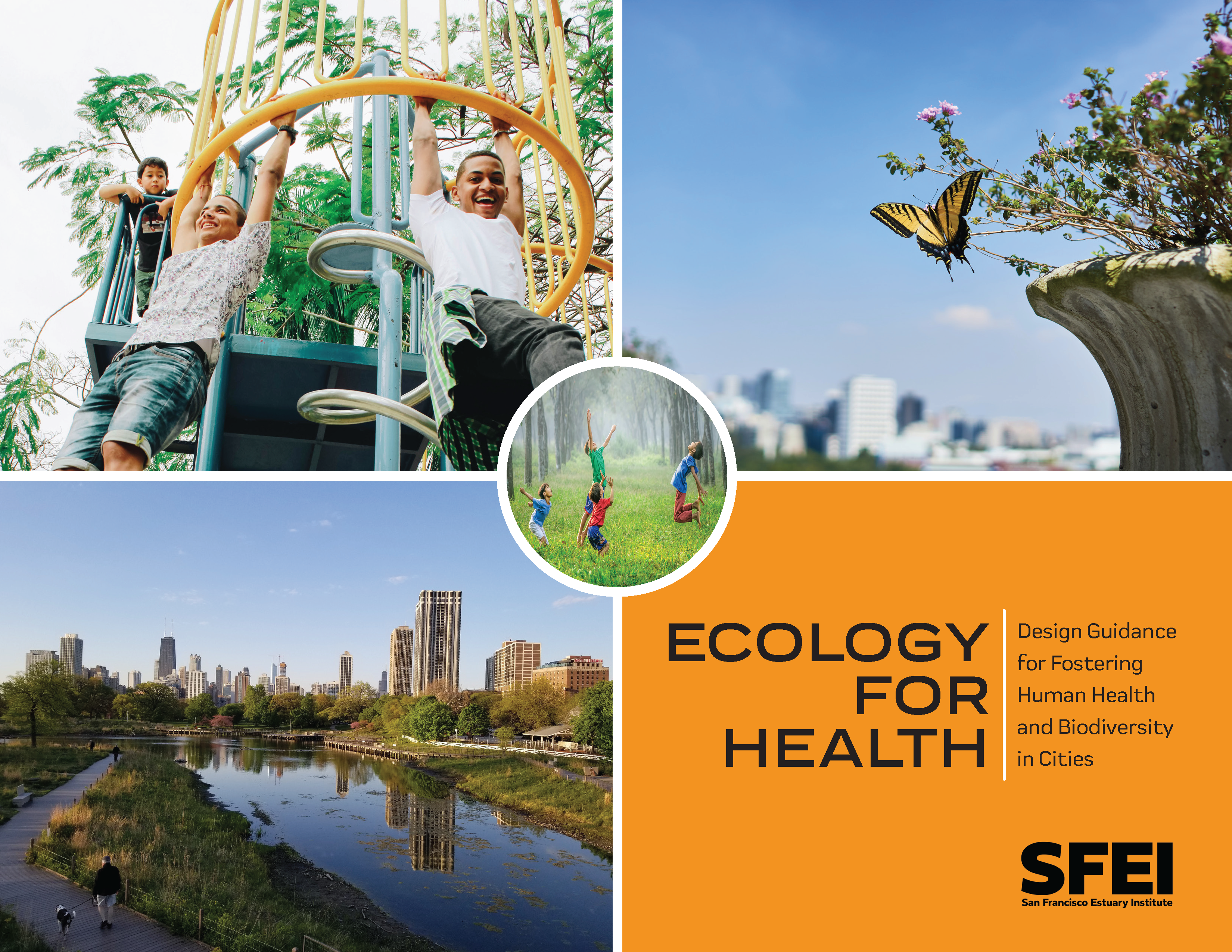 Greenspaces provide crucial nature contact for urban residents. When we have greater access and exposure to nature in the places where we live, work, learn, and play, we tend to experience better human health outcomes. Urban parks, trees, and vegetation encourage physical activity, reduce anxiety and depression, support social cohesion by providing gathering spaces, and are associated with reduced mortality and improved overall health.
While traditionally biodiversity conservation has focused on large open spaces, cities can also play a key role in supporting biodiversity. Many of the world’s major cities developed in biodiversity hotspots due to historical settlement patterns dependent on natural resources. Thus cities contain vital remnant habitat as well as globally important native and endangered species that rely on urban greenspaces.
As urbanization increases, cities around the world are developing and implementing plans to better integrate nature within urban settings. Many of these plans emphasize the importance of urban greening in providing multiple, substantial benefits such as biodiversity conservation, stormwater management, human health and well-being improvements, climate resilience, and more. However not all greenspaces are created equal in their biodiversity support and human health provision.
The goal of this document is to provide science-based guidance for designing urban spaces that foster both human health and urban biodiversity. Anyone making decisions about land use and urban design in cities across the world can benefit from the recommendations in this document (including community organizations, local non-profits, local leaders and policy makers, city planners, urban designers, landscape architects, engineers, gardeners/horticulturists/arborists, residents, and landowners). However, the majority of the document is specifically aimed at supporting designers and planners who work at the planning, site, and detailed design scales such as landscape architects, civil engineers, and urban designers. As noted in more detail in the limitations section below, this document synthesizes global research and design strategies while strongly informed by our experience as scientists and designers in California’s San Francisco Bay Area.
2007. Ecology, Assemblage Structure, Distribution, and Status of Fishes in Streams Tributary to the San Francisco Estuary, California. SFEI Contribution No. 530. San Francisco Estuary Institute and the EPA. p 194.
. 2011. Ecological Monitoring & Assessment Framework: Stream Ecosystem Condition Profile: Coyote Creek Watershed . San Francisco Estuary Institute: Oakland, CA. p 109.
2016. Ecological implications of modeled hydrodynamic changes in the upper San Francisco Estuary: Phase II Technical Memorandum. SFEI Contribution No. 786.
The physical and ecological environment of the upper San Francisco Estuary has been profoundly altered since the early 1800s. Recent efforts have utilized maps of the upper estuary’s historical habitat types to infer associated changes in desired ecosystem processes and functions. The work presented in this memo builds on these previous efforts, but utilizes a new tool for evaluating change over time: a 3D hydrodynamic model of the pre-development estuary. This model was constructed by Resource Management Associates (RMA) using a new digital elevation model of the pre-development upper estuary generated by SFEI and UC Davis (UCD) and “natural” boundary flows calculated by the California Department of Water Resources (CDWR).
Once completed and calibrated, the pre-development model was paired with a similar model of the contemporary system in order to analyze hydrodynamic changes in the upper estuary. These analyses are presented in a technical memorandum published by RMA (2015). This memorandum takes these analyses and considers the ecological implications of modeled changes (see the “Results” section). Hydrodynamic analyses include analyzing changes in tidal prism, isohaline positions, low-salinity zone habitat, channel velocity, and source water distribution.
In addition to describing the ecological implications of modeled hydrodynamic changes, this memorandum summarizes major ongoing questions about estuarine hydrodynamics that might be explored using these models, including changes in water residence time, temperature, transport pathways, and the connectivity of aquatic and semi-aquatic habitats. Understanding changes in these and other factors would greatly improve our understanding of the desirable ecosystem functions provided by the historical system and, as a result, improve our ability to recover these functions now and into the future.
2022. Ecological Horticulture at the Presidio. . SFEI Contribution No. 1080. San Francisco Estuary Institute: Richmond, Ca.
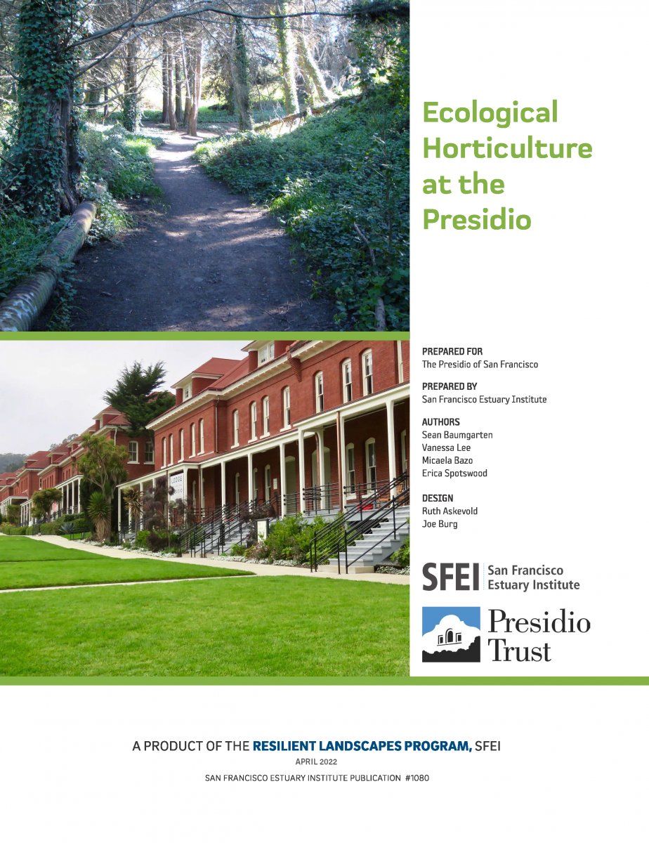 The Presidio of San Francisco—the nation’s largest urban national park—is located in an area of exceptional ecological diversity. Historically, many different habitat types thrived in the mix of windswept dunes, riparian forests, and curious dwarf oak woodlands that characterized this landscape. Many of these habitat types are rare today (and some were even rare in the region historically), and together they harbor a host of unique plants and animals.
1986. Ecological guidelines for the use of natural wetlands for municipal wastewater management in North Carolina. SFEI Contribution No. 134. Division of Environmental Management, North Carolina Department of Natural Resources and Community Development: Raleigh, NC.
2004. Ecological, Geomorphic, and Land Use History of Sulphur Creek Watershed: A component of the watershed management plan for the Sulphur Creek watershed, Napa County, California. SFEI Contribution No. 307. San Francisco Estuary Institute: Oakland.
2004. Ecological, Geomorphic, and Land Use History of Carneros Creek Watershed: A component of the watershed management plan for the Carneros Creek watershed, Napa County, California. SFEI Contribution No. 70. San Francisco Estuary Institute: Oakland.
2007. Ecological Connections between Baylands and Uplands: Examples from Marin County. SFEI Contribution No. 521.
2016. EcoAtlas - Lake Tahoe Environmental Improvement Program: Tool Integration White Paper. SFEI Contribution No. 800.
2021. E-Bikes and Open Space: The Current State of Research and Management Recommendations. SFEI Contribution No. 1064. San Francisco Estuary Institute: Richmond, CA.
2011. East Contra Costa Historical Ecology Study. SFEI Contribution No. 648. SFEI: Oakland.
2009. Dry Creek Watershed Sediment Source Reconnaissance Technical Memorandum. SFEI Contribution No. 595. San Francisco Estuary Institute: Oakland,Ca.
2006. Dredging Impacts on Food-Web Bioaccumulation of DDTs in San Francisco Bay, CA. SFEI Contribution No. 418. San Francisco Estuary Institute: Oakland, CA.
2005. DRAFT REPORT: A Model of Long-Term PCB Fate and Transport in San Francisco Bay, CA. SFEI Contribution No. 388. San Francisco Estuary Institute: Oakland, CA.
2003. Draft Guidelines for Developing the CRAM Metrics. SFEI Contribution No. 284. San Francisco Estuary Institute: Oakland, CA. p 2.
2003. DRAFT California Rapid Assessment (CRAM) Verification Approach. SFEI Contribution No. 283. San Francisco Estuary Institute: Oakland, CA. p p. 9.
1996. DOD Sediment Criteria Project Ambient Analysis Draft Interim Report. SFEI Contribution No. 9. San Francisco Regional Water Quality Control Board: Oakland, CA.
1996. Documenting the intorduction of estuarine foraminifers: a San Francisco Bay Study. Ann. Mtg., Geological Society of America, Denver, CO, Oct. 1996 (abstract).
2018. Dissolved Oxygen in South San Francisco Bay: Variability, Important Processes, and Implications for Understanding Fish Habitat. SFEI Contribution No. 911. San Francisco Estuary Institute : Richmond, CA.
2004. Dioxins in San Francisco Bay: Conceptual Model/Impairment Assessment. SFEI Contribution No. 309. San Francisco Estuary Institute: Oakland. p 60.
2011. DGT (Diffusive Gradient in Thinfilm) as a tool to assess sources of bioavailable methylmercury in San Francisco Bay. SFEI Contribution No. 640. SFEI: Oakland.
2024. Development of Semi-Empirical Light Extinction Estimates for Biogeochemical Modeling Applications in San Francisco Bay. SFEI Contribution No. 1177. San Francisco Estuary Institute: Richmond, CA.
2011. Development of Regional Suspended Sediment and Pollutant Load Estimates for San Francisco Bay Area Tributaries using the Regional Watershed Spreadsheet Model (RWSM): Year 1 Progress Report. SFEI Contribution No. 666. SFEI: Richmond, CA. p 126.
2012. Development of Regional Suspended Sediment and Pollutant Load Estimates for San Francisco Bay Area Tributaries using the Regional Watershed Spreadsheet Model (RWSM): Year 2 Progress Report. SFEI Contribution No. 667. SFEI: Richmond, CA. p 17.
2004. Development of Environmental Indicators of the Condition of San Francisco Estuary. SFEI Contribution No. 113. San Francisco Estuary Institute: Oakland.
2014. Development of Benthic Community Condition Indices – San Francisco Bay. San Francisco Estuary Institute: Richmond, CA.
2008. Development of an environmental indicator system for watershed-based decision-making and tracking the outcomes of beneficial use restoration in the San Joaquin River basin. SFEI Contribution No. 556.
2010. Developing Impairment Thresholds for the Effects of Mercury on Forster's Tern Reproduction in the San Francisco Bay. U. S. Geological Survey: Davis, CA.
2004. Determining Economic Impacts of Aquatic Plant Management in California Waters. SFEI Contribution No. 106.
2010. Desktop Evaluation of Controls for Polychlorinated Biphenyls and Mercury Load Reduction. SFEI Contribution No. 613.
2013. Demonstration Watershed Assessment For the Tahoe Basin Using the Wetland & Riparian Area Monitoring Plan. SFEI Contribution No. 703. San Francisco Estuary Institute: Richmond, CA.
. 2017. Demonstration of a Watershed Approach to Wetland Restoration Planning for Load Reductions: A Pilot Demonstration Project Using GreenPlan-IT in the Santa Rosa Plain, Sonoma County, California. SFEI Contribution No. 996. San Francisco Estuary Institute: Richmond. CA.
This summary memorandum presents technical recommendations to the 401 Certification and Waste Discharge Program (401 Program) of the State Water Resources Control Board (State Board) for a coherent, scientifically sound, repeatable, watershed approach to wetland restoration site evaluation, compliance monitoring and assessment, and Tracking. The recommendations are drawn from the previous four memoranda produced for the Pilot Demonstration Project (Project) that address the following subjects: project work plan and information flow diagram; scientific literature review; landscape scenario planning (to map and prioritize restoration opportunities); and a framework for a watershed-approach to evaluate and report the capacity of a wetland restoration site to protect wetland beneficial uses.
This Project focused on a sub-watershed of the Santa Rosa Plain, in Sonoma County, California. The area was chosen for the Project for three reasons: (1) it is integral to an existing nutrient TMDL and therefore is supported relatively well with hydrological and nutrient data; (2) the historical and existing wetlands and streams of the area were mapped recently in sufficient detail to inform landscape planning; and (3) implementation of the TMDL will involve wetland restoration to reduce downstream nutrient loads, and therefore the Project may help implement the TMDL.
The primary overall purpose of this Project was to explore how numerical simulation and statistical modeling could be combined with existing wetland assessment and reporting tools to create a coherent, watershed-based approach to wetland beneficial use protection. Any relevance to the existing nutrient TMDL for the demonstration area is an intentional, but secondary benefit of this Project.
2022. Delta Wetland Futures: Tidal Marsh Resilience to Sea Level Rise. SFEI Contribution No. 1106. San Francisco Estuary Institute: Richmond, CA.
2022. Delta Wetland Futures: Blue Carbon and Elevation Change. SFEI Contribution No. 1105. San Francisco Estuary Institute: Richmond, CA.
2014. A Delta Transformed: Ecological Functions, Spatial Metrics, and Landscape Change in the Sacramento-San Joaquin Delta. SFEI Contribution No. 729. San Francisco Estuary Institute - Aquatic Science Center: Richmond, CA.
2016. A Delta Renewed: A Guide to Science-Based Ecological Restoration in the Sacramento-San Joaquin Delta. Delta Landscapes Project. Prepared for the California Department of Fish and Wildlife and Ecosystem Restoration Program. A Report of SFEI-ASC’s Resilient Landscapes Program. SFEI Contribution No. 799. San Francisco Estuary Institute - Aquatic Science Center: Richmond, CA.
This report offers guidance for creating and maintaining landscapes in the Sacramento-San Joaquin Delta that support desired ecological functions, while retaining the overall agricultural character and water-supply service of the region. Based on extensive research into how the Delta functioned historically, how it has changed, and how it is likely to evolve, we discuss where and how to re-establish the dynamic natural processes that can sustain native Delta habitats and wildlife into the future. The approach, building on work others have piloted and championed, is to restore or emulate natural processes where possible, establish an appropriate mosaic of habitat types at the landscape scale, use multi-benefit management strategies to increase support for native species in agricultural and urban areas, and allow the Delta to adapt to future uncertainties of climate change, levee failure, and human population growth. With this approach, it will be critical to integrate ecological improvements with the human landscape: a robust agricultural economy, water infrastructure and diversions, and urbanized areas. Strategic restoration that builds on the history and ecology of the region can contribute to the strong sense of place and recreational value of the Delta.
Printed copies of the report are available for purchase.
2018. Delta Regional Monitoring Program Nutrients Synthesis: Modeling to Assist Identification of Temporal and Spatial Data Gaps for Nutrient Monitoring. SFEI Contribution No. 866. Aquatic Science Center: Richmond, CA.
Nutrient loads are an important water quality management issue in the Sacramento-San Joaquin Delta (Delta) and there is consensus that the current monitoring activities do not collect all the information needed to answer important management questions. The purpose of this report is to use hydrodynamic model outputs to refine recommendations for monitoring nutrients and related conditions in the Delta. Two types of modeling approaches were applied: 1) volumetric water source analysis to evaluate the mix of source waters within each subregion; and 2) particle tracking simulations.The analysis revealed that each Delta subregion has a unique “fingerprint” in terms of how much of its water comes from different sources. Three major recommendations for a future monitoring design were derived from this analysis:
Recommendation #1: The subregions proposed for status and trends monitoring in a previous report should be redrawn to better reflect the mixtures of source waters.
Recommendation #2: Long-term water quality stations are needed in the North Delta, Eastside, and South Delta subregions.
Recommendation #3: Areas with a long-residence time and where mixing of different water sources occurs are potential for nutrient transformation hotspots. High-frequency water quality mapping of these areas has the
2018. Delta Regional Monitoring Program Annual Monitoring Report for Fiscal Year 2015–16: Pesticides and Toxicity. SFEI Contribution No. 864. Aquatic Science Center: Richmond, CA.
The primary purpose of this report is to document the first year (FY15/16) of pesticide monitoring by the Delta Regional Monitoring Program (Delta RMP). This document reports the results from samples collected monthly from July 2015 through June 2016. The data described in this report are available for download via the California Environmental Data Exchange Network (CEDEN) website.
Pesticide monitoring of the Delta RMP includes chemical analysis and toxicity testing of surface water samples. The parameters analyzed include 154 current use pesticides, dissolved copper, field parameters, and “conventional” parameters (ancillary parameters measured in the laboratory, such as dissolved/particulate organic carbon and hardness). Toxicity tests included an algal species (Selenastrum capricornutum, also known as Raphidocelis subcapitata), an invertebrate (Ceriodaphnia dubia, a daphnid or water flea), and a fish species (Pimephales promelas, fathead minnow). Toxicity testing included the evaluation of acute (survival) and chronic (growth, reproduction, biomass) toxicity endpoints. The surface water samples were collected from 5 fixed sites representing key inflows to the Delta that were visited monthly: Mokelumne River at New Hope Road, Sacramento River at Hood, San Joaquin River at Buckley Cove, San Joaquin River at Vernalis, and Ulatis Creek at Brown Road.
A total of 52 pesticides were detected above method detection limits (MDLs) in water samples (19 fungicides, 17 herbicides, 9 insecticides, 6 degradates, and 1 synergist). A total of 9 pesticides (5 herbicides, 3 insecticides, and 1 degradate) were detected in suspended sediments in 10 of a total of 60 samples collected during the study period. All collected samples contained mixtures of pesticides ranging from 2 to 26 pesticides per sample. From a total of 154 target parameters, 100 compounds were never detected in any of the samples.
2010. Delta Regional Monitoring Program. Aquatic Science Center: Oakland, CA.
. 2020. Delta Landscapes Scenario Planning Tool User Guide. Version 1.0.0. SFEI Contribution No. 989. SFEI: Richmond, CA.
2020. Delta Landscapes Primary Production: Past, Present, Future. SFEI Contribution No. 988. San Francisco Estuary Institute: Richmond, CA.
This report describes the Delta Landscapes Primary Production project, which quantifies how landscape change in the Delta has altered the quantity and character of primary production. Combining historical and modern maps with simple models of production for five dominant plant and algae groups, we estimate primary production across the hydrologically connected Delta. We evaluate changes in primary production over time (between the early 1800s and early 2000s), between wet and dry years, and with future targets for landscape-scale restoration. For managers in the Delta, restoring historical patterns of primary productivity is a means to better support native fish and other wildlife. To better equip decision makers in managing for improved primary production, this study offers historical context and the best available science on the relative production value of habitat types and their configurations.
2017. Delta Landscapes Executive Summary. SFEI Contribution No. 853.
2017. Delta Landscapes: A Delta Renewed User Guide. SFEI Contribution No. 854.
A Delta Renewed User Guide aims to increase the accessibility of the technical findings in A Delta Renewed for easier application to restoration and conservation efforts across the Delta. The recommendations in A Delta Renewed focus on landscape-scale ecological guidance. We present three examples of how the information in A Delta Renewed might be used to address different management and restoration questions. Because of the complexity of the Delta system, this guide does not address all possible questions and does not replace the need for detailed, site-specific data and expertise. Rather, it shows how the information in A Delta Renewed might provide a common foundation for restoration planning.
The User Guide was written for a broad audience, including restoration practitioners, landowners, and local, state and federal agencies. The guide provides a step-by-step path through A Delta Renewed; a user is walked through how to apply the findings of the report via a series of steps to address each of the three restoration and management questions. This process is intended to help the user access regionally-specific recommendations and strategies to plan and manage future Delta landscapes that can support desired ecological functions over the long term.
The goal of A Delta Renewed and this guide is not to recreate the Delta of the past. Rather, the objective is to understand how we can re-establish or mimic important natural processes and patterns within this altered system to support desirable ecological functions (such as healthy native fish populations, a productive food web, and support for endangered species), now and into the future.
2015. Decentralized Wastewater Discharges and Multiple Benefit Natural Infrastructure: Preliminary Analysis and Next Steps (Final Project Report). East Bay Dischargers Authority .
2023. Data Management Procedures: For Lake County Water Resources Department (LCWRD) and Habematolel Pomo Of Upper Lake (HPUL) Tribe Water Quality Monitoring Data. SFEI Contribution No. 1140. p 18.
2002. Data Collection Protocol Yuma Bat (Myotis yumanensis). SFEI Contribution No. 259. H.T Harvey & Associates: San Jose, CA. p 7.
2002. Data Collection Protocol Tidal Wetland Vegetation. SFEI Contribution No. 279. San Francisco State: San Francisco, CA. p 13.
2002. Data Collection Protocol Survey Protocol for the California Red-Legged Frog (Rana aurora draytonii). SFEI Contribution No. 347. Rana Resources: Fremont, CA. p 15.
2002. Data Collection Protocols Surveying for the Salt Marsh Harvest Mouse [Reithrodontomys raviventris}, California Vole (Microtus califoricus) and other Small Mammals. SFEI Contribution No. 275. Rana Resources, San Jose State University: Fremont, Ca San Jose, Ca. p 14.
2002. Data Collection Protocol Sedimentation- Erosion Tables (SET's). SFEI Contribution No. 244. University of San Francisco, Wetlands and Water Resources: San Francisco, CASan Rafael, CA.
2002. Data Collection Protocol Montioring River Otter (Lutra [=Lontra] canadensis). SFEI Contribution No. 241. CA State University Stanislaus, U.S Forest Service, San Francisco Bay Regional Water Quality Control Board: Oakland, CAStanislaus, CA. p 11.
2002. Data Collection Protocol Distribution, Abundance, and Treatment of Non-indigenous Speicies of Cordgrass in the San Francisco Estuary. SFEI Contribution No. 247. San Francisco Estuary Institute: Oakland, CA. p 44.
1999. Cyanobacterial Populations in San Francisco Bay. SFEI Contribution No. 42. San Francisco Estuary Institute: Richmond, CA.
2020. Current-Use Pesticides, Fragrance Ingredients, and Other Emerging Contaminants in San Francisco Bay Margin Sediment and Water. SFEI Contribution No. 934. San Francisco Estuary Institute: Richmond, CA.
The Regional Monitoring Program for Water Quality in San Francisco Bay (RMP) has recently focused attention on better characterization of contaminants in nearshore “margin” areas of San Francisco Bay. The margins of the Lower South Bay are mudflats and shallow regions that receive direct discharges of stormwater and wastewater; as a result, they may have higher levels of urban contaminants than the open Bay. In the summer of 2017, the RMP collected samples of margin
sediment in the South and Lower South Bay for analysis of legacy contaminants. The study described here leveraged that sampling effort by adding monitoring of sediment and water for two additional sets of emerging contaminants: 1) current-use pesticides; and 2) fragrance ingredients including the polycyclic musk galaxolide, as well as a range of other commonly detected emerging contaminants linked to toxicity concerns such as endocrine disruption.
2018. Current Knowledge and Data Needs for Dioxins in San Francisco Bay. SFEI Contribution No. 926. San Francisco Estuary Institute : Richmond, CA.
2007. Critical Coastal Areas Program, Phase I Final Report. SFEI Contribution No. 541. San Francisco Estuary Institute.
2014. Creating Landscape Profiles of Aquatic Resource Abundance, Diversity and Condition. SFEI Contribution No. 725. San Francisco Estuary Institute - Aquatic Science Center: Richmond, CA. p 21.
2007. CRAM Evaluation of Wetland Conditions. SFEI Contribution No. 544. Elk Grove, California. p 15.
2020. Coyote Creek Watershed Reassessment 2020 Ambient Stream Condition Survey Design and Monitoring Plan: A Review of the Original 2010 Survey Design and Development of the 2020 Reassessment Strategy. . SFEI Contribution No. 1055. San Francisco Estuary Institute: Richmond. CA. p 18.
This technical report describes the ten-year ambient stream condition reassessment survey design and monitoring plan (or strategy) for the Coyote Creek watershed. Because the reassessment employed (and modified) the 2010 sample draw, essential background information about the original 2010 probability-based survey design, sample draw, and field assessment outcomes were provided.
2021. Coyote Creek Watershed Reassessment 2020: 10-Year Reassessment of the Ecological Condition of Streams Applying the California Rapid Assessment Method, Santa Clara County, California. SFEI Contribution No. 1043. San Francisco Estuary Institute: Richmond. CA. p 131.
This report describes the amount and distribution of aquatic resources in the Coyote Creek watershed, Santa Clara County, California, and presents the first reassessment of stream ecosystem conditions using a watershed approach and the California Rapid Assessment Method (CRAM). Field work was conducted in 2020, ten years after the baseline watershed assessment completed in 2010.
2006. Coyote Creek Watershed Historical Ecology Study: Historical Conditions and Landscape Change in the Eastern Santa Clara Valley, California. SFEI Contribution No. 426. San Francisco Estuary Institute.
1998. Contamination of Tidal Wetlands. SFEI Contribution No. 228. Richmond CA.
2006. Contamination Concentrations in Fish from San Francisco Bay, 2003. SFEI Contribution No. 432. San Francisco Estuary Institute.
2011. Contaminants of Emerging Concern in the San Francisco Estuary: Triclosan and Triclocarban. SFEI: Oakland.
2012. Contaminants of Emerging Concern in the San Francisco Estuary: Carbamazepine. SFEI Contribution No. 658. SFEI: Richmond, CA. p 14.
2012. Contaminants of Emerging Concern in the San Francisco Estuary: Alkylphenol Ethoxylates. SFEI Contribution No. 657. SFEI: Richmond, CA. p 17.
2013. Contaminants of Emerging Concern in San Francisco Bay: A Summary of Occurrence Data and Identification of Data Gaps. SFEI Contribution No. 698. p 121.
2020. Contaminants of Emerging Concern in San Francisco Bay: A Strategy for Future Investigations 2020 Update. SFEI Contribution No. 1007. San Francisco Estuary Institute: Richmond, CA.
This 2020 CEC Strategy Update is a brief summary document that describes the addition of recently monitored CECs to the tiered risk-based framework. Reviews of findings relevant to San Francisco Bay are provided, as is a discussion of the role of environmental persistence in classifying CECs within the framework. The Strategy is a living document that guides RMP special studies on CECs, assuring continued focus on the issues of highest priority to protecting the health of the Bay. A key focus of the Strategy is a tiered risk-based framework that guides future monitoring proposals. The Strategy also features a multi-year plan indicating potential future research priorities.
2013. Contaminants of Emerging Concern in San Francisco Bay: A Strategy for Future Investigations. San Francisco Estuary Institute: Richmond, CA.
2017. Contaminants of Emerging Concern in San Francisco Bay: A Strategy for Future Investigations. 2017 Revision. SFEI Contribution No. 815. San Francisco Estuary Institute: Richmond, CA.
2018. Contaminants of Emerging Concern in San Francisco Bay: A Strategy for Future Investigations 2018 Update. SFEI Contribution No. 873. San Francisco Estuary Institute: Richmond, CA.
2015. Contaminants of Emerging Concern in San Francisco Bay: A Strategy for Future Investigations. 2015 Update. Contaminants of Emerging Concern in San Francisco Bay: A Strategy for Future Investigations. SFEI Contribution No. 761. San Francisco Estuary Institute: Richmond, CA.
About this Update
The Regional Monitoring Program for Water Quality in San Francisco Bay (RMP) has been investigating contaminants of emerging concern (CECs) since 2001. CECs can be broadly defined as synthetic or naturally occurring chemicals that are not regulated or commonly monitored in the environment but have the potential to enter the environment and cause adverse ecological or human health impacts.
The RMP Emerging Contaminants Workgroup (ECWG), established in 2006, includes representatives from RMP stakeholder groups, regional scientists, and an advisory panel of expert researchers that work together to address the workgroup’s guiding management question – Which CECs have the potential to adversely impact beneficial uses in San Francisco Bay? The overarching goal of the ECWG is to develop cost-effective strategies to identify and monitor CECs to minimize impacts to the Bay.
To this end, the RMP published a CEC Strategy document in 2013 (Sutton et al. 2013). The strategy is a living document that guides RMP special studies on CECs, assuring continued focus on the issues of highest priority to the health of the Bay. A key focus of the strategy is a tiered risk and management action framework that guides future monitoring proposals. The strategy also features a multi-year plan indicating potential future research priorities.
This 2015 CEC strategy update features revised designations of CECs in the tiered risk and management action framework based on monitoring and research conducted since 2013. Brief summaries of relevant RMP findings are provided. In addition, a proposed multi-year plan for future RMP Special Studies on CECs is outlined. A full revision of the CEC strategy is anticipated in 2016.