Scott Dusterhoff

Scott Dusterhoff, MS
Program Managing Director & Senior Scientist
Sediment
Resilient Landscapes Program
Shoreline Resilience
Watershed Science & Management
Scott Dusterhoff is a Senior Scientist and Managing Director of the Resilient Landscapes Program at the San Francisco Estuary Institute. He is an experienced geomorphologist with a background in fluvial geomorphology, watershed hydrology, and estuarine/tidal wetland dynamics. For more than two decades, Scott has been working in coastal and upland watersheds throughout California, Oregon, and Washington, as well as in the Mid-Atlantic, on projects that use in-depth scientific investigations to inform sustainable ecosystem management approaches. He specializes in understanding the impacts of land disturbance and flow regulation on geomorphic processes and aquatic habitat for a variety of endangered species. He has extensive experience using a combination of field-based data, numerical modeling, and geospatial tools to characterize fluvial and coastal sediment transport dynamics and hydrologic/hydraulic processes. Scott received a B.S in Geology from the University of Maryland and an M.S. in Environmental Sciences and Hydrology from the University of Virginia.
Related Projects, News, and Events
 Landscape Vision for Calabazas Creek, San Tomas Aquino Creek and Pond A8 (Project)
SFEI released a resilient landscape vision for the interface of Calabazas Creek, San Tomas Aquino Creek, and Pond A8 in South San Francisco Bay that benefits both flood management and bayland habitat restoration.
 Vision for Upper Penitencia Creek completed! (News)
SFEI recently completed a resilient landscape vision for Upper Penitencia Creek in San Jose that integrates flood management and ecosystem support. SFEI and the Santa Clara Valley Water District worked with technical advisors and local stakeholders to develop the vision, which identifies a range of multi-benefit management opportunities that increase flood storage in a manner that expands recreational amenities, supports water supply needs, and enhances habitat for a variety of native fish and wildlife species.
 Restoration Vision for the Laguna de Santa Rosa Completed! (News)
SFEI completed a long-term Restoration Vision for the Laguna de Santa Rosa in the Russian River watershed. SFEI, Sonoma Water, and the Laguna de Santa Rosa Foundation worked with technical advisors, stakeholders, and landowners to develop the Restoration Vision, which identifies opportunities for multi-benefit habitat restoration and land management that supports people and wildlife.
 Vision for the Calabazas Creek, San Tomas Aquino Creek, and Pond A8 (News)
SFEI recently released a resilient landscape vision for the interface of Calabazas Creek, San Tomas Aquino Creek, and Pond A8 in South San Francisco Bay that benefits both flood management and bayland habitat restoration. The vision, developed in coordination with a team of regional science experts, explores a reconfigured shoreline that could improve ecosystem health and resilience, reduce maintenance costs, and protect surrounding infrastructure.
 Investigating the future of sediment in the San Francisco Bay (News)
SFEI scientists are currently working with regional partners and science advisors to assess the future sediment supply to the Bay and how that compares to the sediment needed for baylands to survive sea-level rise. Currently, baylands (tidal marshes and mudflats) are receiving enough sediment to keep pace with sea-level rise. However, sea-level rise is expected to accelerate in the coming decades, which could cause baylands to drown unless they get more sediment.
 Riparian zone decision support tool just released! (News)
In April 2015, SFEI released a GIS-based decision support tool called the Riparian Zone Estimation Tool (RipZET). RipZET was developed with funding by the State Water Resources Control Board to assist watershed managers and restoration practitioners in the visualization and characterization of riparian areas next to streams and wetlands. The tool’s innovative approach uses readily accessible data to determine “functional riparian width,” which varies throughout a watershed based on local vegetation and topographic conditions.
 Upper Penitencia Creek: Resilient Landscape Vision (Project)
The San Francisco Estuary Institute-Aquatic Science Center and the Santa Clara Valley Water District worked with technical advisors and a group of local stakeholders to explore a range of multi-benefit management opportunities along Upper Penitencia Creek, culminating in this Resilient Landscape Vision. The vision focuses on ways to expand flow conveyance and flood water storage from the Coyote Creek confluence upstream to the Dorel Drive bridge in a manner that works with the existing landscape features and supports habitats for native species.
 Sonoma Creek Baylands Strategy (Project)
The Sonoma Creek Baylands Strategy is a comprehensive high-level plan for landscape-scale restoration, flood protection, and public access in the tidal Lower Sonoma Creek portion of the San Pablo Baylands.
The Strategy:
 Petaluma Valley Historical Hydrology and Ecology Study (Project)
This project reconstructs the historical hydrology and ecology of the Petaluma River watershed prior to major Euro-American modification. It demonstrates the efficacy of historical hydrology and ecology in identifying and prioritizing multi-benefit restoration opportunities.
 North San Diego County Lagoons Historical Ecology Study (Project)
The Northern San Diego County Lagoons Historical Ecology Investigation draws on hundreds of historical documents to analyze and reconstruct historical landscape conditions for six northern San Diego County estuaries prior to the major modifications of the late 19th and 20th centuries.
 Lower Walnut Creek Historical Ecology Study (Project)
During the mid-19th century, the lower Walnut Creek watershed was a landscape dominated by extensive wetlands, meandering creeks, and grassy plains. The marshes, sloughs, and meadows provided habitat and food for a huge number of wildlife species ranging from grizzly bears and elk to clapper rails and steelhead. Over the past 150 years, urban development, diking and filling of wetlands, and channelization of streams has resulted in dramatic changes to the watershed, and much of the historical habitat has been lost.
 Lower Laguna de Santa Rosa and Mark West Creek: Changes in Historical Channel Alignment (Project)
Over the past century and a half, the hydrology of the Laguna de Santa Rosa watershed has been altered by a variety land use changes, including urbanization, agricultural development, draining and filling of wetlands, and channelization of streams. These changes have impacted the function of the Laguna and Mark West Creek and contributed to a range of contemporary management problems, including habitat degradation, impaired water quality, altered sediment dynamics, salmonid stranding, flooding, and trash accumulation.
 Historical Ecology and Landscape Change in the Central Laguna de Santa Rosa (Project)
This study synthesizes a diverse array of data to examine the ecological patterns, ecosystem functions, and hydrology that characterized a central portion of the Laguna de Santa Rosa during the mid-19th century, and to analyze landscape changes over the past 150 years. The primary purpose of this study was to help guide restoration actions and other measures aimed at reducing nutrient loads within this portion of the Laguna de Santa Rosa watershed.
 SFEI is working with the Santa Clara Valley Water District to develop multi-benefit management tools (News)
In 2014, SFEI and the Santa Valley Water District launched a collaborative partnership aimed at sharing experience, knowledge and resources, and working toward a shared vision of watershed management. Through this partnership, the District has asked SFEI to develop a set of online tools to: 1) identify opportunities for multi-benefit management actions in and along the channels managed by the District; and 2) track the impacts of those actions towards meeting established management targets.
 Petaluma River Watershed: A Slough of Change (Event)
Come learn about an exciting report recently completed by the San Francisco Estuary Institute (SFEI) and Sonoma RCD on the historical ecology of the Petaluma River watershed. SFEI will highlight interesting details about the history of this unique watershed and share insights about how historical data can be used to improve future management and conservation decisions. Anyone interested in learning more about the past, present, and future of the Petaluma River is encouraged to attend.
 Flood Control 2.0 Wins an Outstanding Environmental Project Award! (News)
The Flood Control 2.0 project team was presented with an Outstanding Environmental Project Award at the 13th Biennial State of the Estuary Conference in Oakland, CA. The award is given by the Friends of the San Francisco Estuary to projects that benefit the San Francisco-Bay Delta Estuary and its watersheds.
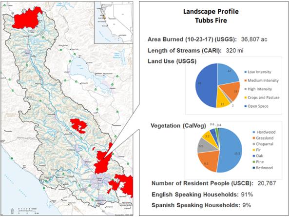 Russian River Watershed Atlas helps track and coordinate post-fire activities (News)
Fire recovery in the Russian River Watershed will benefit from a common online platform for compiling, visualizing, and interpreting many kinds of environmental data available from diverse federal, state, regional, and local sources. Providing such a platform is one objective of the Russian River Regional Monitoring Program (R3MP).
 Flood Control 2.0 Completed! (News)
SFEI and several agency partners recently completed a multi-year, EPA funded project called Flood Control 2.0. The goal of the project was to develop information that is useful for integrating habitat restoration into flood management at the Bay edge. Project outputs are now available at floodcontrol.sfei.org.
 South Bay Landscape Vision Workshop (News)
On June 7, SFEI, in partnership with the Santa Clara Valley Water District and South Bay Salt Ponds Restoration Project, hosted a landscape “visioning” workshop in San Jose. The goal of the workshop was to develop a resilient, multi-benefit vision highlighting opportunities along the South Bay shoreline for supporting both tidal marsh restoration and flood management.
 Lower Walnut Creek Vision Just Released! (News)
SFEI recently released a resilient landscape vision for lower Walnut Creek that incorporates habitat restoration actions into flood risk management. The vision, developed in coordination with a team of regional science experts, highlights opportunities for restoring and sustaining vital tidal wetland habitats around lower Walnut Creek while supporting a high level of flood protection under rising San Francisco Bay water levels.
- ‹ previous
- 2 of 3
- next ›