California Rapid Assessment Method (CRAM)
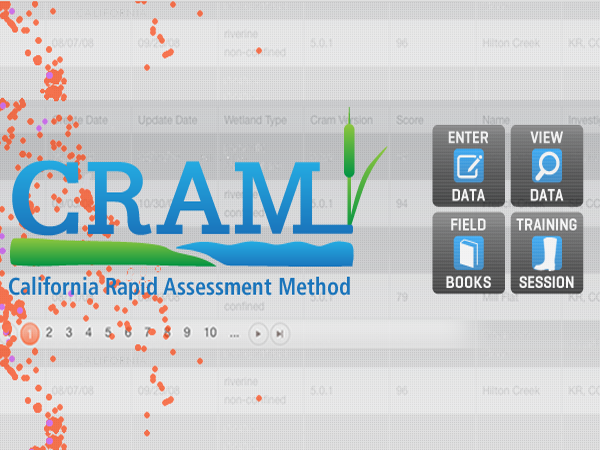
SFEI develops, hosts and manages the California Rapid Assessment Method (CRAM) website and its associated database containing over 5,000 landscape assessments from across the State. The comprehensive site features statewide support for CRAM data managment, training, documentation, and reporting tools to monitor and assess over seven kinds of wetlands using standardized rapid assessment protocols developed by the CRAM Steering Committee (Level-2 Committee). Appointed by the California Wetland Monitoring Workgroup (CWMW), the Level-2 Committee meets quarterly to review and maintain CRAM's field manuals, training procedures, data management, and reporting tools. The L-2 Committee is chaired by a staff member from the State Water Board and includes wetland scientists and technical staff from state and federal agencies with regulatory or managment responsibility for the health of aquatic resources as well as from academia and other scientific organizations across the state.
CRAM is a cost-effective and scientifically defensible rapid assessment method for monitoring and assessing the ecological conditions of wetlands throughout California. It takes less than half a day to assess a wetland area, and is designed evaluate the condition of the wetland based on its landscape setting, hydrology, physical structure and biological structure. Because the methodology is standardized for over seven types of wetlands, ecological condition scores can be compared at the local, regional and statewide landscape scales.
CRAM can also be used to assess the performance of compensatory mitigation projects and restoration projects. The easy-to-use, online data entry forms ensures that all of the appropriate site information and field data associated with CRAM assessments can be archived online and access by environmental managers, planners, and stakeholders to inform wetland management and planning decisions. The ability to draw the CRAM assessment area online using an aerial image of the site, makes it easy for CRAM practitioners to enter their site information making it available on EcoAtlas (if allowed by the landowner). Public CRAM assessment areas are also available as a web service, which affords a broad degree of availability and transparency to support contemporary open-data initiatives.
Dates:
2002 to 2018
Partners:
Funders:
Associated Staff:
Project Site:
Subproject(s):
Associated Data:
Programs and Focus Areas:
Environmental Informatics Program
Resilient Landscapes Program
Wetland Monitoring & Assessment
Related Projects, News, and Events:
 Santa Clara Valley Water District Priority D5 Project's Watershed Condition Assessments (2010 to present) (Project)
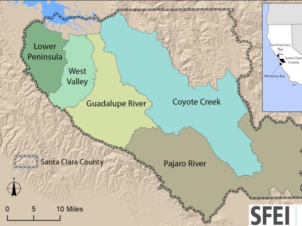
https://www.valleywater.org/project-updates/2012-d5-ecological-data-collection-and-analysisSFEI and the Santa Clara Valley Water District's (Valley Water) Priority D-5 Project have been conducting baseline ecological condition assessments in Santa Clara County, CA to characterize the distribution and abundance of stream and wetlands in five major watersheds, and to assess the overall ecological conditions of streams in the watersheds based on the California Rapic Assessment Method for streams (CRAM). The surveys employ the state's recommended Wetland and Riparian Area Monitoring Plan's watershed aproach that includes the use of GIS-base maps of aquatice resources (BAARI), and spatially-balanced ambient stream condition surveys using CRAM.
 Get on the curve: Habitat Development Curves help determine the performance of on-the-ground projects (News)
How do you know if the ecological conditions of your wetland project are aligned with expected rates of improvement?
 The Wetlands Regional Monitoring Program for SF Estuary enters significant new phase (News)
The Wetlands Regional Monitoring Program or WRMP is a broad, multi-organizational effort designed to produce coordinated and rigorous science about the baylands in the San Francisco Bay area. Through the power of diverse partnerships, a broad network of stakeholders are working rapidly to protect and restore wetlands that can provide flood protection, tribal, community and recreational benefits, water quality improvement, wildlife habitat, and other benefits for surrounding communities. To meet a regional target of 100,000 acres restored by 2030, close coordination is needed between managers, scientists, community groups, tribal partners, and regulators. However, this project-by-project approach to restoration monitoring has left our state, regional, and local decision makers effectively insensitive to the overall regional conditions that might bear direct influence over restoration success and failure. As the effects of climate change and sea level rise generate their own set of challenges, the WRMP will improve the success of wetland restoration projects by putting in place regionally coordinated monitoring that will increase the impact, utility and application of monitoring to inform adaptive management.
 EcoAtlas (Project)
EcoAtlas is a set of tools for generating, assembling, storing, visualizing, sharing, and reporting environmental data and information.
 Wetlands Regional Monitoring Project (Project)
This Prop 50 - funded project was a three-year effort to monitor and track changes in Bay Area wetland condition. This wetland monitoring toolkit meets basic information needs for managing wetlands: to develop a scientific framework with standard methods for monitoring wetlands and for interpreting the results, and to regularly report the findings to the public. These monitoring tools are intended to help provide a public measure of the environmental costs or benefits of most wetland management actions.
 Statewide Wetland Tracking, Science, and Policy Development Support (Project)
SFEI’s Wetland Science Focus Area’s Director, Josh Collins, is a leader in the coordination of statewide science advisory teams and acquiring funding to develop monitoring and assessment tools that support the State’s Wetland and Riparian Area Protection Policy.
 California Rapid Assessment Method for Wetlands (CRAM) Updates (News)
CRAM Training sessions for 2020 have been posted on the CRAM website.
 Assessing Five Watersheds in Santa Clara County (News)
A new synthesis report characterizing the amount, distribution, and diversity of streams and wetlands within the County employing CARI, and an ambient survey of the overall ecological condition of streams employing CRAM.
This Friday morning (6/21/2019) from 6am to 9am, there will be planned internet downtime at SFEI to improve our organization's bandwidth and service capacity for the many things we do for you.
The early-morning outage will impact the following sites/tools:
- EcoAtlas
- CD3
- CRAM
- Enviz
- Project Tracker
Thank you for your cooperation. If you have any questions or concerns, please let us know at [email protected].
 SFEI Announces New Wetlands Web Tools (News)
SFEI, on behalf of the Wetland Monitoring Workgroup is releasing a series of technology tools to help with aquatic resource protection and management. “These new online tools will empower Californians to access information about the value and health of their wetlands,” said U.S. Environmental Protection Agency Regional Administrator Jared Blumenfeld. “The release of the Wetlands Portal and EcoAtlas represents a multi-agency collaborative effort to inform the public and support better aquatic resource management.”
 CRAM Bar-Built Estuarine (BBE) module now available to expand the applicability of CRAM (News)
With funding from the State Coastal Conservancy, SFEI staff developed the eCRAM data entry forms for uploading BBE assessments into the CRAM database. Public assessments can be viewed on EcoAtlas' interactive map and downloaded using the CRAM filter tool.
 Evaluation of CRAM performance for assessing wetland stress, small wetlands, and wetland habitat development (Project)
Caltrans funded this wetlands research to fill important gaps in knowledge about the ability of the California Rapid Assessment Method (CRAM) to assess small wetlands, wetlands stress, and the rate at which wetland restoration projects develop into mature habitats. Caltrans proposed specific tasks based on the research priorities provided by the CRAM Commitee of the statewide California Wetlands Monitoring Workgroup.
 California Wetlands Portal (Project)
The California Wetlands Portal, one of the State of California’s My Water Quality portals, is the common data management system for the State’s primary wetland protection policies and programs, including the 401 Certification and WDR Programs, the proposed Wetland and Riparian Protection Policy, and the State’s No-Net-Loss Policy.