Topographic Map Interpretation
Contents
Everything up to now can be applied to topographic maps as well as other kinds of maps and information. The rest of this discussion focuses specifically on how you can use topographic maps to extract information about the landscape. Both physical and cultural features are often discernible from topographic maps. This section draws many ideas from a course handbook titled "The Language of Maps," by my advisor at the University of Minnesota, Phil Gersmehl.
The US Geological Survey has published many different kinds of maps, including several series of topographic maps. Only a few series are in common use. The 7 1/2-minute quadrangles, which have a scale of 1:24,000, are the most popular. These detailed maps are supplemented by the 1:250,000-scale series. A third series, the 15-minute quad at 1:62,500, was popular but discontinued by the USGS for mysterious reasons (probably because the detailed 1:24,000 maps had to be done, and the 1:62,500s would duplicate some of their uses). The 1:100,000-scale metric series is a recent addition, and is now complete for the US. All of its maps show features in metric, for example elevation is in meters.
Table : USGS Topographic Map Series
Series |
Scale |
Lat. x Long |
Area (mi2) |
Paper Size |
7-1/2 Minute |
1:24,000 |
7-1/2' x 7-1/2' |
49-70 |
22" x 27" |
15-Minute |
1:62,500 |
15' x 15' |
197-282 |
17" x 21" |
Metric |
1:100,000 |
30' x 1ª |
3,173-4,334 |
|
1:250,000 |
1:250,000 |
1ª x 2ª |
6,346-8,669 |
24" x 34" |
1:1,000,000 |
1:1,000,000 |
4ª x 6ª |
73,734 x 102,759 |
27" x 27" |
A. Physical Features 
In addition to this section, see also the discussion of contour lines and slopes above under Symbolization in Part I. You may also want to read (or reread) a text @ecoatlas.GIS.physical geography or geology to help in understanding the terms and concepts here.
1. Landforms
Contour lines and other map symbols can give you clues about the geology and geomorphology that underlies the landscape. In general, rocks differ in their resistance to weathering and erosion, and these differences are reflected in the landscape. Some examples:
Fault lines.
Some faults can sometimes be seen on a map where streams have been offset to the left or right along a line, then continue downstream. These are strike-slip, or transform, faults, where one section of the crust is sliding past another. California's San Andreas and associated faults are examples of transform faults. In other faults, one section of the crust slides under another. These normal or reverse faults are usually less visible unless considerable uplift has occurred. Death Valley is the result of a pair of normal faults letting the valley floor downward several thousand meters.
Cuestas and hogbacks. These are the result of a block of terrain being tilted upward at one end. The result is a gradual upward slope with a cliff at the uplifted end. Good examples of these can be found in the desert Southwest.

Volcanoes.
In contrast to most hills, volcanoes are usually much rounder, so that contour lines around them are circular. This is especially true for stratovolcanoes, the most violent and prominent volcanoes. Examples are Mt. Shasta in California and Mt. Rainier in Washington. Some volcanic eruptions are gentler and form gentler hills or even broad plateaus. These flows are more difficult to detect from the topographic map, unless the USGS adds a dotted pattern that indicates a lava flow.

Wave Action.
Waves are very efficient at cutting back into cliffs. The waves crash against the base of the cliff and undercut the cliff. Eventually a chunk of cliff topples into the sea. But waves don't cut down much below sea level, especially where the rock along the shore is relatively hard. The result is that wave action can create a long wave-cut platform or terrace along the shore. These platforms are often visible on coastal maps.

If the coast is uplifted, this flat wave-cut (or marine) terrace can be high and dry above the ocean. The California coast has been rising relative to the sea over the past several hundred thousand years. In many areas a series of terraces are visible on maps and in person. The Sea Ranch, along the coast in northern Sonoma County, is built on a marine terrace.
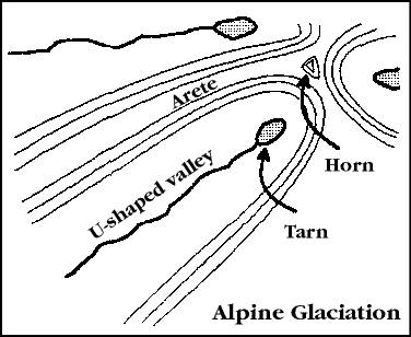
Glaciation.
Glaciers can occupy either mountainous or flat terrain, and result in corresponding alpine or continental glacial features. Many kinds of features can result, so I'll mention only a couple of examples. For alpine glaciation, the ice will occupy a valley and hollow out its sides and head. This turns the valley from V-shaped to U-shaped, with steep sides and flat bottom. Small lakes may form in the valley, known as tarns. As it excavates into the mountain at the head of the valley, another glacier may be doing the same on the other side of the mountain. This results in a sharp ridge, or arete. If three glaciers surround and erode a mountain, they may form a three-sided peak, known as a horn (the Matterhorn is the best-known example). California's Sierra Nevada was covered by glaciers during the last glacial peak (about 15,000 years ago), and many of these features remain as evidence.
Continental glaciers, or ice sheets, produce different landforms. The most striking is where the glacier's front has remained stationary for a long period. The glacial ice will be moving forward toward the front, carrying rock and debris in the ice. The ice melts at the front and leaves the debris as a moraine. Moraines are hilly ridges perhaps a mile wide and up to several hundred miles long. They may have a hundred feet of local relief (vertical elevation change). The ridges contain many depressions that fill with water. If you see a map with irregular hills and many small lakes, glaciation may be the cause. Ice sheets covered most of the upper Midwest, down to about the Missouri and Ohio Rivers. Nearly all of Minnesota's 10,000 lakes were formed by glaciers. California didn't have any continental glaciation to speak of--only alpine.
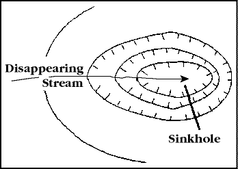
Karst.
Another type of area with irregular terrain, sometimes with many lakes, is known as karst. Karst forms in limestone and other rock that easily dissolves in water. The water dissolves both the surface and the subsurface. Caves result below the surface--most caves are formed in limestone rock (Carlsbad Caverns, Mammoth Cave, etc.). But the surface may also show the result of being dissolved: sinkholes (small depressions) and disappearing streams (where a stream suddenly vanishes) are evidence. Karst is common in Indiana, Kentucky, Arkansas, Missouri, and Florida (where houses have been swallowed by sinkholes). California has a small area of karst in the Marble Mountains, in the extreme northern part of the state.
Winds.
Winds rarely shape the landscape enough to show on topographic maps. The exception is in areas with accumulations of loose sand, which wind can move effectively. Sand may accumulate in deserts, along shores, or where the bedrock is sandstone. The wind usually shapes the sand into dunes. There are many types of dunes, mostly due to different wind speeds and directions. Often the wind is consistent enough from one direction to line up the dunes, so a linear pattern shows up on the topographic map. Streams are usually absent or rare, since water flows into and through the dunes easily. Topographic maps usually show sand dunes with a distinctive dotted pattern. Large sand seas are found in the Nebraska Sand Hills, White Sands National Monument, and southeastern California.
Mass movement.
Gravity affects all events on Earth, but it is the defining force in mass movement. Landslides, rockfalls, and slumps are all examples of mass movement. When a slope becomes too steep for the cohesive forces retaining it, it gives way. The reasons for gravity overcoming the slope can include uplift from a fault, an earthquake, a stream undercutting a slope, burning of vegetation that holds the slope, or excavation by humans. Small mass movements may be too small and temporary to be visible on a topographic map. Large landslides and slumps may be evident, especially in certain areas where they are frequent. Mountains are good candidates. Sonoma County is also prime terrain, as winter rains saturate hills that have been overgrazed, undercut or built upon.
2. Drainage Patterns
The terminology of drainage patterns is not particularly useful in and of itself. But drainage patterns can suggest what is happening with the underlying geology and landscape.
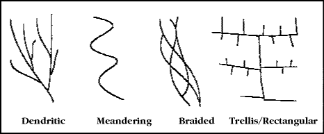
Dendritic.
The "normal" pattern of stream drainage is called dendritic, since it looks like a tree's roots or branches. This pattern occurs when no strong geological factor controls the drainage network.
Meandering.
A stream that has had a chance to erode for a long period tends to widen its path across a large floodplain, and meander back and forth across the floodplain. These streams usually flood periodically and fill their floodplain. While unwise to build on the floodplain, the land is usually flat and fertile, and tempting for short-sighted settlers. These streams are often channelized into straight courses. This rids the local area of water quickly but creates even more flooding downstream.
Braided.
Some streams in floodplains have many small channels that merge and separate downstream. Braided streams are most common where the water flow is variable (e.g., deserts or mountains) and the stream bed is mostly sand and gravel.
Trellis & Rectangular.
These patterns are where streams flow in straight segments and turn at sharp angles. Usually this results from sedimentary bedrock controlling the direction of streams along the surface. Good examples of trellis drainage are found in eastern Pennsylvania, where folded sedimentary rocks cause streams to flow at right angles to each other.
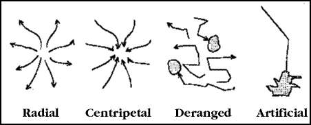
Radial.
Radial drainage occurs around circular hills and mountains, with streams radiating out in all directions. This would be typical around a volcano.
Centripetal.
The opposite of radial, here streams drain inward toward a central basin. The basin usually has a dry or saline lake and has no outlet--a sign of arid conditions.
Deranged.
Streams have no organized pattern. Some drain externally toward major rivers, others may drain internally. This is usually a sign of continental glaciation, or possibly sand dunes or karst.
Artificial.
Human-caused modifications of streams include channelized streams (straighter than any normal stream), canals, drainage ditches (may be a sign of natural wetlands), reservoirs (which not only have a dam, but usually a more indented shoreline than a natural lake), and levees.
3. Vegetation
USGS topo maps often contain some indication of vegetative cover, but not always. Older maps lack this information, and some kinds of vegetation aren't indicated.
Forest and woodland.
USGS maps indicate forest or woodland (area with trees but not continuous canopy cover) by a uniform green tint. The size, orientation and shape of tree cover can tell us about climate and land use. Types of cover patterns include:
- Treeline forests, in higher elevations where cold climate prevents trees from growing any higher;
- Moisture-favorable forests, in canyons, ravines, on slopes away from the Sun (especially north slopes), or up slopes in arid lands;
- Dry-land forests, on drier islands in wetlands; good examples may be seen in Florida's Everglades, in "mahogany hammocks";
- Landslides or avalanche chutes, where falling rock or snow keeps areas clear of mature trees;
- Human-caused forest patterns, including clearcuts with sharp edges in otherwise forested land; bottomland forests in wet areas where the surrounding land has been cleared; and woodlots, shelterbelts and windbreaks around farms and ranches.
Orchards and vineyards.
USGS topos give these distinctive patterns of regular dots. It is interesting to examine where these have been placed on the terrain--usually up above the valley floor slightly to avoid cold-air drainage that occurs at night.
Scrub.
Scrub or shrub vegetation has an irregularly-dotted pattern. Chaparral vegetation in California normally has this pattern, although it is not always mapped. Chaparral is a sign of Mediterranean climate, that is, mild, wet winters and warm, dry summers. Soil is also a factor. For example, in our area, soils that dry out thoroughly in summer are more likely to harbor chaparral.
Wetland vegetation.
USGS topographic maps have distinctive symbols for wooded wetland (also called swamp), nonforested marsh, and mangroves. Mangroves are shrub or small tree-sized plants that grow directly in warm salt water along tropical and subtropical coasts. Florida and other Gulf Coast states have many mangrove areas, although many have been cleared for development.
B. Cultural Features
1. Transportation Patterns
Besides the types of roads listed in the key for topographic maps (primary, secondary, light-duty, unimproved), look also at the placement of the road. It may follow along elevation contours, even if the route is circuitous--an indication of steep terrain, relative to the amount of traffic carried. Heavily-traveled routes tend to get straightened.
Other areas may have roads that follow flat terrain, and cross steep slopes only when connecting level areas. The flat areas are either valley floors, with few roads going over mountains, or mesas or interfluves, where the flat land is dissected by streams. The Appalachians are good places to find transportation along valleys. A glance at a road map of eastern Pennsylvania will indicate that valleys and hills trend from southwest to northeast. Southern California has good examples of mesas, most of which are marine terraces formed long ago and since lifted above the sea.
Grid patterns are the rule where areas were surveyed before settlement, as in most lands under the Public Land Survey system. Roads in these areas often follow the square grid regardless of terrain.
Don't overlook other kinds of transportation, such as railroads, canals, and trails. These often indicate something about the history or land use of an area. A map with many railroads, for example, likely says the area was important during the early 20th Century. You also may notice corridors that used to be railroads--often shown as "old railroad grade." Many of these are being converted to foot trails or bicycle paths. Canals for transportation are rarely built nowadays, but were popular in the 19th Century.
2. Rural Settlement
Rural housing.
Rural houses and buildings are usually shown on topographic maps as small black squares. Rural settlement patterns usually reflect the original land survey. Regions surveyed under the PLS started out with a very dispersed settlement pattern. Homes were scattered on farms and ranches, usually no more that four per square mile. Areas surveyed under irregular survey systems (metes-and-bounds, land grants, etc.) tend to have homes more clustered, or along roads that went through or around land parcels. Land in long-lot surveys typically has houses closely spaced along a few main roads or rivers, with few houses elsewhere.
Service facilities.
Along major transportation routes in rural areas, small settlements sprung up to service travelers and their vehicles. These settlements concentrated at railroad stations in the 19th and early 20th Centuries. As the automobile became the primary means of transporting people in the mid-20th Century, service facilities became more dispersed along highways. With travel more concentrated on interstate highways, facilities and settlements are once again becoming more concentrated, this time at major exits on interstates.
Urban invasion.
Many rural areas have been "invaded" by urbanites for summer or weekend homes, or even long-distance commute homes. Lakes and rivers are popular places, especially in more arid regions of the West. Campgrounds, resorts, and other tourist facilities have expanded rapidly in the past few decades. A dense pattern of these indicate either a nearby metropolitan area (such as Sierra Nevada resort areas), an unusually popular location (such as Yosemite or Redwood parks), or a wealthy clientele (such as Aspen or Vail).
3. Urban Development
The patterns of streets and facilities in urban areas can suggest much about the function and history of the city. Often you must investigate the particular groups that settled the area to fully appreciate the patterns. The myriad groups who immigrated to the US brought their own traditions of land-use. Of particular influence were the English, French, German, and Spanish. Subtle influences of others, such as Native Americans or Asians, can sometimes be detected.
Irregular street patterns.
Early in our history, streets were laid out according to the major trading routes and the shape of the land. This produced an irregular pattern, especially in smaller towns.
Regular grid patterns.
Most cities adopted regular grids for streets to make surveying and development easier. This is particularly true in PLS areas. At first, street grids were oriented with respect to the major transportation line, even if the line went northwest-southeast. Later, most street grids were oriented north-south and east-west. The changing pattern can be seen in many cities as they grew outward from the center.
Irregular patterns, again.
In the past few decades, the regular grid of street became associated with uniform houses and middle-class lifestyles. Wealthy people (and some who want to look like they are) like to distinguish themselves from ordinary folk, and have used winding, irregular streets for their housing to do so. This also goes along with the trend in the US for wealthy people to live in hills above the city; regular grids would be difficult here anyway.
Industrial areas are often visible on topographic maps as clusters of larger buildings, and may help discern the area's function. Economic geographers often divide industries into raw materials-oriented, such as gravel pits and food processing plants; those in manufacturing, which often cluster together where power, labor or transportation is available; and market- and service-oriented, which cluster where customers are, for example bottling plant, shopping malls and strip developments.
4. Place-names
Place-names often give clues about the area's history or occupants. Often this can suggest a series of different groups in an area, or sequent occupance in geographic jargon. In California, of course, many names reveal the Spanish and Mexican presence--which is both historical and continues today. Town names are not the only clue. Other words were applied to places and have stuck, sometimes as more reliable than city names. For example, I doubt many of these communities were founded by Spanish-speakers: Del Mar, Tierrasanta, San Anselmo, El Cerrito, San Carlos and Rancho Mirage. On the other hand, words like verde, agua, mesa, arroyo, iglesia, and oso occur on maps as part of other names and indicate early settlement by the Spanish. Laguna lake is redundant--laguna means lake in Spanish--and the name may reveal an early Spanish presence.
Other groups settled throughout the US, and even California. Groups including French, German, Czech, Swedish, Norwegian, Danish, Irish, Polish, Chinese, Korean, Japanese, and recently Vietnamese and Hmong have established place-names. The Russians colonized the northwestern coast of North America in the early 19th Century, and some place-names remain even where few Russians do (Sitka, Petersburg, Soldotna, Andreanov Islands, etc.). Sebastopol, however, is a later revision having nothing to do with the Russian city other than the name itself.
5. Mining
Mining operations disturb local areas, sometimes severely. Topographic maps often show mining pits with a distinctive shading pattern (see Topographic Map Symbols brochure). Gravel pits and quarries also receive a point symbol. We could also include oil and gas wells here, indicated on topo maps; presence of many such wells suggest a major contribution to the local economy. Oftentimes other clues also reveal mining, especially past mining: irregular contours that do not match the general trend of the landscape, unexpected depressions shown by contours, and rail lines or roads dead-ending in the area. Large mines, such as strip mines in the Appalachians and open-pit copper mines in Arizona show these features prominently on topo maps.
C. Conclusion
Topographic maps can be a rich source of information about a landscape, even absent other information. It is a good idea to use collateral information, such as histories or geographies of an area, before sharing your conclusions with friends and relatives. Remember, maps are representations of reality, not reality itself!