The California Aquatic Resources Inventory (CARI) is a seamless statewide map compiled from multiple data sources and standardized to a common classification system. This statewide dataset provides the best available map of inland state surface waters and serves as the base map in EcoAtlas to coordinate monitoring and assessment at the landscape scale across federal, state, and local agencies, while providing enough detail to inform local land use planning.
How is CARI Used?
CARI is a Geographic Information System (GIS) dataset of inland surface waters and their riparian areas consisting of polygon and line features with data-rich attributes that can be used for developing broad- or fine-scale landscape summaries of aquatic resource quantity and quality. Accompanying CARI is the CARI Editor, an interactive, online GIS mapping interface that facilitates user-generated updates to information associated with the CARI dataset. When users encounter any discrepancy between CARI and the actual landscape, they can suggest changes that can be reviewed and incorporated into the authoritative CARI data, thereby maintaining CARI’s currency and ready applicability to decision making.
This statewide dataset is hosted online through EcoAtlas, an online toolset that supports the State’s three level monitoring and assessment framework described in the Tenets of a State Wetland and Riparian Area Monitoring Plan (WRAMP), which in-turn advances the State’s Wetland and Riparian Area Protection Policy (WRAPP). The WRAMP framework employs the Federal Environmental Protection Agency’s (EPA’s) recommended three level monitoring and assessment framework for wetlands of which the first level includes landscape level assessments and profiles. CARI is the statewide base-map for those assessments.
Why is it important to monitor the condition of a wetland?
Photo: Chad Roberts
Wetlands serve many functions for people and wildlife – including furnishing habitat, offering wildlife refugia, filtering contaminants, sequestering carbon, and buffering waves from rising sea levels. However, those many functions are compromised when a wetland is functioning poorly. One might call such a wetland “unhealthy.” Therefore, as stewards of the environment, we must take an active role in assessing the health of our wetlands. Such information can lead to decisions and actions to ensure that our wetlands not only survive but also thrive. A wetland in the highest condition offers the greatest suite of ecosystem benefits.
Wetland recovery can take a very long time. Even with active wetland restoration projects, habitat development can take decades, and there can be many obstacles to a successful outcome. That’s why it is important that we repeatedly monitor the condition of our wetlands, to get timely information that can help inform actions we can take to correct any adverse impacts or slower-than-expected habitat development.
Those interested in monitoring our creeks, rivers, marshes, vernal pools, and other wetland features need cost-effective, standardized ways to measure change over time, so that one site can be compared to another and its “health” measured as objectively as possible.
Rapid assessments speed delivery of actionable information
The California Rapid Assessment Method or CRAM is a standard method to measure the condition of various wetland features. Used across the state, CRAM features reference sites, a structured system of metrics, and a host of analytical tools to ensure the highest quality of information to guide decision making. And as a rapid assessment method, its cost effectiveness makes possible repeat site visits and its adoption by programs across the state. Furthermore, on EcoAtlas, it works hand-in-hand with more intensive site monitoring to address specific scientific monitoring questions.
California and its partners developed the method over decades. This investment of time, resources, and ideas has produced one of the nation’s best methods for assessing the condition of wetlands. It is now practiced across the state by hundreds of licensed practitioners. Because the methodology is standardized for seven major types of wetlands and their subtypes, it is broadly applicable throughout California and can be used to compare wetlands to each other and over time at local, regional and statewide scales.
CRAM offers many benefits including:
a suite of metrics specifically tuned to different types of wetlands
routine training to impart details of the method, calibrate among practitioners, and ensure intercomparable results
public access to timely data and information
an interorganizational governance structure to ensure consistent management and use of the method and its data
standards-based analytical tools including habitat development curves, cumulative distribution function, and ecological condition bins
The rapid assessment information about wetland condition offers both a high-level view to decision-makers and more detailed information for wetland managers, researchers, and other stakeholders.
How are rapid assessment data used?
With over 8,000 assessments available throughout California, CRAM has become a trusted tool to help land managers determine where to deploy resources to adjust wetland restoration projects plans, anticipate impacts, and compare site conditions across the state. The Southern California Wetlands Recovery Project uses CRAM to judge the efficacy of its wetland restoration efforts. Meanwhile, Caltrans trusts CRAM as a way to demonstrate its effective stewardship of aquatic resources adjacent to or within its right of way.
As a vital component of the Wetland and Riparian Area Monitoring Program (WRAMP) framework – pairing remote sensing data with rapid condition assessments and more intensive monitoring – the California Rapid Assessment Method works harmoniously with traditional, intensive site monitoring, which is still required by permits and research. Rapid assessments are not designed to replace intensive monitoring, but rather, they can be used to screen potential sites and determine where more expensive monitoring might be most effective.
The method is available to all who are properly trained. New CRAM practitioners are always welcome. Learn more about CRAM and how you might either use or produce wetland condition information.
Want to know where to find habitat projects?
Habitat restoration includes voluntary restoration, restoration/re-establishment, and restoration/rehabilitation. More and more groups rely on Project Tracker to assist with their reporting because Project Tracker standardizes project data across programs for analytical and reporting purposes. It is the most comprehensive dataset for project information in most regions of California.
Project Tracker as the Best Source of Project Information for the SF Estuary
The San Francisco Bay Joint Venture tracks their habitat projects in Project Tracker so they can advance projects and generate summaries on progress towards meeting regional goals. Additionally, Project Tracker can assist with developing survey designs that target data collection near restoration sites.
Keep it up!
You can help make regional rep orting more accurate and complete by entering your projects into Project Tracker and keeping the information up-to-date. Projects are also visualized and integrated with other datasets in EcoAtlas. For more information, visit ecoatlas.org.
Synthesized project information contributed by restoration practitioners and permittees can be dynamically queried in understandable regional summaries. Agency and program executives can quickly access relevant information to address management questions. As interactive summaries, the dashboards are useful in the context of local, regional, and statewide agency programs, where interested users can explore the summarized information at various spatial scales.
The dashboards also reveal differences in the availability of information from place to place. By helping to identify missing information, the EcoAtlas dashboards will help address these gaps in the future.
If you are interested in accessing data on a project-by-project basis, then the EcoAtlas download tools provide ready access to the hosted project data. You are able to filter by numerous geospatial, categorical, and other means.
A Toolset to Operationalize Established Science
EcoAtlas is the toolset of the Wetland and Riparian Area Monitoring Plan (WRAMP) developed by the California Wetland Monitoring Workgroup (CWMW). The toolset’s functions, data, and resulting outputs -- maps, charts, and analyses -- reflect the methods and peer-reviewed studies that emerge from WRAMP. The WRAMP Framework page contains a trove of studies, reports, and presentations that demonstrate the support for the WRAMP framework and EcoAtlas. A central aspect of the WRAMP framework is a classification of environmental data, their methods of collection, and their stated purposes into the following three levels:
Maps and spatial information. These data consist of map-based inventories of aquatic areas and related resources, including rivers, streams, lakes, bays, wetlands, and their riparian areas, plus events and activities that have a direct effect on the distribution, abundance, diversity, or condition of aquatic resources. Maps may serve to plan and conduct landscape and watershed profiles of aquatic resource condition.
General wetland condition information. This extensive dataset comprises rapid, field-based semi-quantitative measures of the overall condition or health of aquatic resources. In California, the California Rapid Assessment Method (CRAM) is the most widely used method for assessing the overall health of wetlands and streams. Other assessment tools exist and may also be used when needed.
Specific condition information. These datasets are quantitative, field measurements of specific aspects of condition. Plant species composition, nesting bird surveys, spawning success, and groundwater recharge rates are examples of these data types.
The toolset enjoys funding, data, and in-kind services from a variety of organizations, including but not limited to:
state agencies, such as the Regional and State Water Boards, CalTrans, and California Department of Fish and Wildlife;
federal agencies, such as the US Army Corp of Engineers and NOAA-NMFS, which stores its Southern California eelgrass restoration projects in EcoAtlas;
local agencies, such as Flood Control Districts, Water Agdencies, and Resource Conservation Districts that have sponsored tool development.
special districts, such as flood control, resource conservation, and mosquito abatement districts;
non-governmental agencies, such as SCCWRP, Central Coast Wetlands Group, SFEI, and Joint Ventures.
Who Uses EcoAtlas?
In addition, EcoAtlas, CRAM, CARI and Project Tracker were included in Proposition 1 guidelines for managing information on restoration projects. The CWMW and its associated technical committees will continue to guide development of EcoAtlas and other WRAMP toolsets. EcoAtlas development will continue to be funded by grants and contracts to the EcoAtlas development and user communities. US Environmental Protection Agency, San Francisco Bay Restoration Authority, California State Water Resources Control Board, the San Francisco Bay Conservation and Development Commission, the California Ocean Protection Council, State Coastal Conservancy, and California Department of Fish and Wildlife have provided substantial funding, in-kind services, or datasets for tool enhancements over recent years.
More About our Partners
Learn more about the many partners who support the toolset.
EcoAtlas is a set of tools for generating, assembling, storing, visualizing, sharing, and reporting environmental data and information. The tools can be used individually or together, and they can be adjusted or tuned to meet the specific needs of environmental planners, regulators, managers, scientists, and educators. The maps and tools can be used to create a complete picture of aquatic resources in the landscape by integrating stream and wetland maps, restoration information, and monitoring results with land use, transportation, and other information important to the state’s wetlands.
EcoAtlas is a set of tools for generating, assembling, storing, visualizing, sharing, and reporting environmental data and information. The tools can be used individually or together, and they can be adjusted or tuned to meet the specific needs of environmental planners, regulators, managers, scientists, and educators.
The California Aquatic Resources Inventory (CARI) is a seamless statewide map compiled from multiple data sources and standardized to a common classification system. This statewide dataset provides the best available map of inland state surface waters and serves as the base map in EcoAtlas to coordinate monitoring and assessment at the landscape scale across federal, state, and local agencies, while providing enough detail to inform local land use planning.
How is CARI Used?
CARI is a Geographic Information System (GIS) dataset of inland surface waters and their riparian areas consisting of polygon and line features with data-rich attributes that can be used for developing broad- or fine-scale landscape summaries of aquatic resource quantity and quality. Accompanying CARI is the CARI Editor, an interactive, online GIS mapping interface that facilitates user-generated updates to information associated with the CARI dataset. When users encounter any discrepancy between CARI and the actual landscape, they can suggest changes that can be reviewed and incorporated into the authoritative CARI data, thereby maintaining CARI’s currency and ready applicability to decision making.
This statewide dataset is hosted online through EcoAtlas, an online toolset that supports the State’s three level monitoring and assessment framework described in the Tenets of a State Wetland and Riparian Area Monitoring Plan (WRAMP), which in-turn advances the State’s Wetland and Riparian Area Protection Policy (WRAPP). The WRAMP framework employs the Federal Environmental Protection Agency’s (EPA’s) recommended three level monitoring and assessment framework for wetlands of which the first level includes landscape level assessments and profiles. CARI is the statewide base-map for those assessments.
Why is it important to monitor the condition of a wetland?
Photo: Chad Roberts
Wetlands serve many functions for people and wildlife – including furnishing habitat, offering wildlife refugia, filtering contaminants, sequestering carbon, and buffering waves from rising sea levels. However, those many functions are compromised when a wetland is functioning poorly. One might call such a wetland “unhealthy.” Therefore, as stewards of the environment, we must take an active role in assessing the health of our wetlands. Such information can lead to decisions and actions to ensure that our wetlands not only survive but also thrive. A wetland in the highest condition offers the greatest suite of ecosystem benefits.
Wetland recovery can take a very long time. Even with active wetland restoration projects, habitat development can take decades, and there can be many obstacles to a successful outcome. That’s why it is important that we repeatedly monitor the condition of our wetlands, to get timely information that can help inform actions we can take to correct any adverse impacts or slower-than-expected habitat development.
Those interested in monitoring our creeks, rivers, marshes, vernal pools, and other wetland features need cost-effective, standardized ways to measure change over time, so that one site can be compared to another and its “health” measured as objectively as possible.
Rapid assessments speed delivery of actionable information
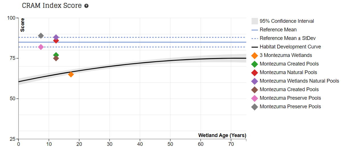
The California Rapid Assessment Method or CRAM is a standard method to measure the condition of various wetland features. Used across the state, CRAM features reference sites, a structured system of metrics, and a host of analytical tools to ensure the highest quality of information to guide decision making. And as a rapid assessment method, its cost effectiveness makes possible repeat site visits and its adoption by programs across the state. Furthermore, on EcoAtlas, it works hand-in-hand with more intensive site monitoring to address specific scientific monitoring questions.
California and its partners developed the method over decades. This investment of time, resources, and ideas has produced one of the nation’s best methods for assessing the condition of wetlands. It is now practiced across the state by hundreds of licensed practitioners. Because the methodology is standardized for seven major types of wetlands and their subtypes, it is broadly applicable throughout California and can be used to compare wetlands to each other and over time at local, regional and statewide scales.
CRAM offers many benefits including:
a suite of metrics specifically tuned to different types of wetlands
routine training to impart details of the method, calibrate among practitioners, and ensure intercomparable results
public access to timely data and information
an interorganizational governance structure to ensure consistent management and use of the method and its data
standards-based analytical tools including habitat development curves, cumulative distribution function, and ecological condition bins
The rapid assessment information about wetland condition offers both a high-level view to decision-makers and more detailed information for wetland managers, researchers, and other stakeholders.
How are rapid assessment data used?
With over 8,000 assessments available throughout California, CRAM has become a trusted tool to help land managers determine where to deploy resources to adjust wetland restoration projects plans, anticipate impacts, and compare site conditions across the state. The Southern California Wetlands Recovery Project uses CRAM to judge the efficacy of its wetland restoration efforts. Meanwhile, Caltrans trusts CRAM as a way to demonstrate its effective stewardship of aquatic resources adjacent to or within its right of way.
As a vital component of the Wetland and Riparian Area Monitoring Program (WRAMP) framework – pairing remote sensing data with rapid condition assessments and more intensive monitoring – the California Rapid Assessment Method works harmoniously with traditional, intensive site monitoring, which is still required by permits and research. Rapid assessments are not designed to replace intensive monitoring, but rather, they can be used to screen potential sites and determine where more expensive monitoring might be most effective.
The method is available to all who are properly trained. New CRAM practitioners are always welcome. Learn more about CRAM and how you might either use or produce wetland condition information.
Want to know where to find habitat projects?
Habitat restoration includes voluntary restoration, restoration/re-establishment, and restoration/rehabilitation. More and more groups rely on Project Tracker to assist with their reporting because Project Tracker standardizes project data across programs for analytical and reporting purposes. It is the most comprehensive dataset for project information in most regions of California.
Project Tracker as the Best Source of Project Information for the SF Estuary
The San Francisco Bay Joint Venture tracks their habitat projects in Project Tracker so they can advance projects and generate summaries on progress towards meeting regional goals. Additionally, Project Tracker can assist with developing survey designs that target data collection near restoration sites.
Keep it up!
You can help make regional rep orting more accurate and complete by entering your projects into Project Tracker and keeping the information up-to-date. Projects are also visualized and integrated with other datasets in EcoAtlas. For more information, visit ecoatlas.org.
Synthesized project information contributed by restoration practitioners and permittees can be dynamically queried in understandable regional summaries. Agency and program executives can quickly access relevant information to address management questions. As interactive summaries, the dashboards are useful in the context of local, regional, and statewide agency programs, where interested users can explore the summarized information at various spatial scales.
The dashboards also reveal differences in the availability of information from place to place. By helping to identify missing information, the EcoAtlas dashboards will help address these gaps in the future.
If you are interested in accessing data on a project-by-project basis, then the EcoAtlas download tools provide ready access to the hosted project data. You are able to filter by numerous geospatial, categorical, and other means.
A Toolset to Operationalize Established Science
EcoAtlas is the toolset of the Wetland and Riparian Area Monitoring Plan (WRAMP) developed by the California Wetland Monitoring Workgroup (CWMW). The toolset’s functions, data, and resulting outputs -- maps, charts, and analyses -- reflect the methods and peer-reviewed studies that emerge from WRAMP. The WRAMP Framework page contains a trove of studies, reports, and presentations that demonstrate the support for the WRAMP framework and EcoAtlas. A central aspect of the WRAMP framework is a classification of environmental data, their methods of collection, and their stated purposes into the following three levels:
Maps and spatial information. These data consist of map-based inventories of aquatic areas and related resources, including rivers, streams, lakes, bays, wetlands, and their riparian areas, plus events and activities that have a direct effect on the distribution, abundance, diversity, or condition of aquatic resources. Maps may serve to plan and conduct landscape and watershed profiles of aquatic resource condition.
General wetland condition information. This extensive dataset comprises rapid, field-based semi-quantitative measures of the overall condition or health of aquatic resources. In California, the California Rapid Assessment Method (CRAM) is the most widely used method for assessing the overall health of wetlands and streams. Other assessment tools exist and may also be used when needed.
Specific condition information. These datasets are quantitative, field measurements of specific aspects of condition. Plant species composition, nesting bird surveys, spawning success, and groundwater recharge rates are examples of these data types.
The toolset enjoys funding, data, and in-kind services from a variety of organizations, including but not limited to:
state agencies, such as the Regional and State Water Boards, CalTrans, and California Department of Fish and Wildlife;
federal agencies, such as the US Army Corp of Engineers and NOAA-NMFS, which stores its Southern California eelgrass restoration projects in EcoAtlas;
local agencies, such as Flood Control Districts, Water Agdencies, and Resource Conservation Districts that have sponsored tool development.
special districts, such as flood control, resource conservation, and mosquito abatement districts;
non-governmental agencies, such as SCCWRP, Central Coast Wetlands Group, SFEI, and Joint Ventures.
Who Uses EcoAtlas?
In addition, EcoAtlas, CRAM, CARI and Project Tracker were included in Proposition 1 guidelines for managing information on restoration projects. The CWMW and its associated technical committees will continue to guide development of EcoAtlas and other WRAMP toolsets. EcoAtlas development will continue to be funded by grants and contracts to the EcoAtlas development and user communities. US Environmental Protection Agency, San Francisco Bay Restoration Authority, California State Water Resources Control Board, the San Francisco Bay Conservation and Development Commission, the California Ocean Protection Council, State Coastal Conservancy, and California Department of Fish and Wildlife have provided substantial funding, in-kind services, or datasets for tool enhancements over recent years.
More About our Partners
Learn more about the many partners who support the toolset.
The California Aquatic Resources Inventory (CARI) is a Geographic Information System (GIS) based map of wetlands, streams, and riparian areas within California that is hosted online through EcoAtlas.
Eelgrass (Zostera marina and Z. pacifica) is recognized as an important ecological resource in nearshore open coast areas, shallow bays, and estuaries throughout coastal California.
EcoAtlas, SFEI's flagship product launched last summer, was just awarded three Wetland Program Development grants by the USEPA for further enhancement and support. In partnership with the Delta Conservancy, State Water Board, and Regional Water Boards, SFEI staff will (1) add new quantitative field data layers, and enhance the tool’s visualization and dynamic project reporting; (2) develop training materials and cost estimates for regional stewardship of EcoAtlas; and (3) create a business plan to sustain EcoAtlas as an interagency tool into the future.
With California's drought rapidly changing the outlook for natural resources, decision-makers must be equipped with information and tools that facilitate clear and rapid decisions. The proposed grant would fund the standardization, visualization, and sharing of Level 3 data.
An accurate basemap is fundamental to watershed planning and assessments. The California Aquatic Resources Inventory, or CARI, offers such a basemap for aquatic resource identification and classification. But to keep it current and enhance its details, SFEI-ASC must leverage local knowledge. The new CARI Editor promotes regional stewardship and allows users to submit updates, deletions or new features for streams and wetlands.
CRAM is a standardized, scientifically defensible rapid assessment method for monitoring the ecological conditions of wetlands throughout California. Because it is standardized, one can compare ecological conditions of wetlands locally, regionally and statewide.
This project is funded by a USEPA wetland development grant (2015-2017) to develop a recommended funding and business model for the EcoAtlas toolset. EcoAtlas is a framework and toolset recommended in the State's Wetland and Riparian Area Monitoring Plan (WRAMP) of the California Wetland Monitoring Workgroup (CWMW). The tools enable users to visualize and assess the distribution, abundance, diversity, and condition of surface waters in a landscape or watershed context. The Business Plan project is developing several overview and planning memos and a final, compiled recommendation for an EcoAtlas business plan. Those documents are made available here as they are completed.
The recent EcoAtlas release delivers new functionality and enhancements to the Landscape Profiler, a tool that summarizes ecological information at various spatial scales for assessment, planning, and reporting. Users can upload a KML file, edit the boundary, and save a polygon for their area of interest. Additional datasets are summarized in the Landscape Profile Report, including the revised 2011 National Land Cover Dataset, eelgrass survey data along the coast from Humboldt Bay to San Diego Bay, and percentages of languages spoken from the US Census data.
New data layers and Landscape Profile mode have been added to EcoAtlas (ecoatlas.org), an online tool for visualizing the abundance, diversity, and condition of wetlands, along with the project activities that are affecting the landscape. Enhancements include:
This project will create an EcoAtlas user community for the Lahontan region of the Sierra Nevada to develop capacities within the region to apply EcoAtlas through existing local, regional, state, and federal programs to track projects and summarize map-based and rapid assessment information at the watershed scale.
The Lahontan Water Board (Regional Water Board 6) has formally adopted EcoAtlas and the California Rapid Assessment Method (CRAM). This will enable the Water Board to visually track and assess the extent of project impacts on a watershed basis throughout the region.
Beginning August 1 of this year, 401 Certifications and Waste Discharge Requirements will require applicants to upload project information into EcoAtlas. Applicants will be encouraged to use CRAM in pre- and post- project assessments.
In addition to making water quality data accessible, SFEI’s GIS Team compiles spatial datasets and metadata that are available for downloading from SFEI’s Data Center page.
Eelgrass (Zostera marina and Z. pacifica) is recognized as an important ecological resource in nearshore open coast areas, shallow bays, and estuaries throughout coastal California. Access to regional maps and related monitoring reports for eelgrass is crucial to monitor the extent of eelgrass habitat and how it is changing over time, evaluate the effects of coastal development projects on eelgrass habitat, and inform interested stakeholders and the public about eelgrass distribution.
Information and maps for 168 projects from the San Diego Regional Water Quality Control Board were uploaded to the Project Tracker database. These projects can be viewed on EcoAtlas and the California Wetlands Portal. This project also provided guidance and training to support the San Diego Regional Water Quality Control Board's participation in the Online 401 Pilot Study.
The CRAM Bar-Built Estuarine module is used for assessing reaches of coastal rivers and streams that are ecologically influenced by seasonal closures of their tidal inlets.
How can someone click on a map and almost immediately determine the upstream catchment area to that designated point? StreamStats is a web service provided by the US Geological Survey to perform that critical function.
The service can be seamlessly incorporated into web maps to enhance their catchment-finding abilities. In July 2015, USGS released a new version of their StreamStats service, which SFEI recently incorporated into EcoAtlas.
 The Place for Aquatic Resources
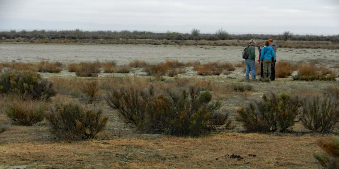

 Want to know where to find habitat projects?
 A Toolset to Operationalize Established Science
 EcoAtlas Support


")


